|
Valley Forge National Historical Park Chapter 9 |

|
|
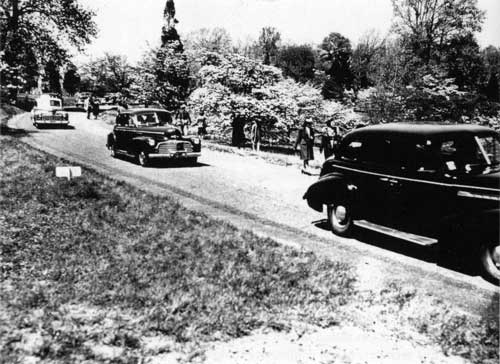
CHAPTER NINE: The Siege of Valley Forge The late 1930s and early 1940s saw the first manifestations of real crowd-control problems at Valley Forge, particularly in the spring, when the impressive concentration of flowering dogwood trees dedicated to Washington and his army drew almost a million visitors annually. A 1936 memo decreed: "We cannot allow visitors all the time they may desire. They must be satisfied with such view as they get moving along or else our physical task will be too difficult." [1] How to deal with the hordes of visitors as well as people who wanted to locate permanently at Valley Forge became a key park issue between the 1950s and 1976 as the general area became increasingly developed. Concurrent bad press, financial problems, and trouble between the park commission and its parent organization caused individuals involved at Valley Forge and concerned members of the community to develop a kind of siege mentality. When the National Park Service took over Valley Forge on July 4, 1976, its uniformed rangers were welcomed like the cavalry arriving at a besieged frontier town. An era of highway-building opened immediately after World War II, soon bringing a modern high-speed artery to the very edge of Valley Forge State Park. In 1944, land in Upper Merion Township was condemned to make way for the Pennsylvania Turnpike. A local editorial titled "A Threat to Hallowed Acres" acknowledged that highways were necessary but protested that "few persons are of the opinion that these adjuncts of the twentieth century should be permitted to disfigure those shrines which are a part of this nation's glorious past." [2] For almost a year, the park commissioners had been trying to second-guess what effect the turnpike would have on Valley Forge, but they made no official protest. [3] And indeed, other than making the park more easily reached by travelers from distant parts of the state, the new road brought no real changes to Valley Forge. Change would come once the Schuylkill Expressway provided a high-speed route from the turnpike's Valley Forge exit directly to downtown Philadelphia. The expressway had evolved from plans for a "Valley Forge Parkway," proposed as early as 1930 to link Valley Forge and Fairmount Park. [4] After World War II, the expressway was again proposed as an alternative to widening existing roadways. Its planned route was to follow the Schuylkill River to Gulph Mills, where it would join a yet-to-be-built Route 202 near Valley Forge State Park. Construction began in 1950, and the Schuylkill Expressway officially opened in 1958. On the very first day, traffic became snarled, but the road system then in place made it inevitable that the village near Valley Forge with the peculiar name "King of Prussia" would become a major hub of commercial and industrial development, a kind of satellite community outside the city of Philadelphia.
As the King of Prussia area was developed, still more highways were needed to handle the traffic, and the impact of development on Valley Forge increased. Park commissioners voiced concern that highways would "strangle" the park [5] and unsuccessfully protested the building of a giant cloverleaf near the park's eastern entrance. [6] In 1965, another highway called the County Line Expressway (Route 422) divided what little remained of Port Kennedy, leaving nothing but a church, a deteriorating mansion, and a few structures near the old railroad station, all of them strangely separated by roads that were almost impossible for pedestrians to cross. The volume of traffic through the park also increased, posing new threats to some well-known landmarks. In 1967, the one-lane covered bridge spanning Valley Creek, which had been built in 1865 and restored as recently as 1960, was closed for several weeks after an overloaded tractor trailer attempted to cross it, almost completely knocking out one of its sides. [7] Businesses hastened to locate at this new, convenient thoroughfare, and many of them wanted the cachet of a Valley Forge address. Around 1960, efforts were made to build a new post office in Valley Forge village, which would also accommodate tourists who wanted a Valley Forge stamp cancellation. Kenneth D. Wells of the Freedoms Foundation protested, expressing in a letter his desire that the proposed post office would not serve the new industrial areas of King of Prussia, or make a Valley Forge address available to those outside the "confines of the reservation." [8] Nevertheless, the new post office was dedicated in 1964, a Colonial-style building designed to blend tastefully into its noble surroundings. [9] In 1962, the Freedoms Foundation approved plans for commercial development on property just west of Valley Forge. These plans would have enabled a builder to erect a concentration of shops, a restaurant, "sleeping units," and a theater. [10] Park commissioners joined with others involved at Valley Forge in protesting what they considered an attack on the park's still-undeveloped western border. Historian John Reed protested to Schuylkill Township supervisors: "Freedoms Foundation, by its own admission, chose to site itself at Valley Forge because of the historical allusions of the place. It seems to me that it is a shame that the Foundation should be allowed, or should even wish, to pervert those allusions by selling property for the proposed [11] The proposed shops never materialized. Certain members of the local community reacted to the threat of development with a plan to surround Valley Forge with a buffer circle of land divided into fifty parcels on which each state could erect a building of Georgian design that tourists could visit and that could provide housing for visiting students. The plan may have been inspired by world's fair structures or perhaps by the Colonial-style campus being erected at the Freedoms Foundation. A 1967 pamphlet titled "Valley Forge Crisis" proclaimed that the shrine was "threatened by a booming urban build-up that is taking place in the King of Prussia area." [12] Joseph Perron, whose name appeared on the pamphlet, presented the idea to the park commission in 1968. The DAR had already introduced the plan to the director of the Pennsylvania Historical and Museum Commission, [13] and there were other supporters too, including renowned novelist James Michener. [14] The park commissioners withheld their support, claiming that such plans were out of their purview, but commission minutes suggested hope that the same effect could be achieved if Montgomery and Chester counties would each locate a community college on the park's perimeter, [15] Without the park commissioners' active support, the grassroots buffer plan was abandoned by the end of the year. [16] The park commissioners continued to deal with each new development project bordering the park as a separate issue. The park commission deemed plans for a Dutch Inns Motel adjacent to the park "undesirable," contending that such an establishment would sell liquor and create additional traffic problems. [17] Park officials contacted local residents and other interested parties to oppose the zoning changes that would allow such a motel. [18] They succeeded in quashing plans for the motel, later opposing a second motel plan and a youth hostel as "not in keeping" with Valley Forge Park. [19] The commissioners' opinions were initially divided when plans were presented for the Sheraton Hotel and Convention Center, a much larger operation than anything previously proposed, but one that would be located a bit southeast of the park's main entrance. [20] Citizens protested what was rumored to become a complex of high-rise buildings almost overlooking the park. One couple objected to the encroachment of commercialism on a "national treasure" where "peace and beauty refresh the spirit; its very existence remind[ing] us of a proud moment in our nation's history." [21] Park commissioners declared that they would not oppose zoning changes if the Sheraton would be no taller than six or seven stories. [22] The Sheraton, of course, eventually stretched much higher than that; it was and is visible from Outer Line Drive. Once the Sheraton complex was completed, the park commissioners were more vocal in resisting another affront, a proposed 15-foot-high rotating sign on top of the building. [23] |
|
| ||
| <<< PREVIOUS | CONTENTS | NEXT >>> |
|
Valley Forge ©1995, The Pennsylvania State University Press treese/treese9.htm — 02-Apr-2002 | ||