


Survey of Historic Sites and Buildings
 |
FORT MEADE South Dakota |
 |
| ||
Control of the Sioux and protection of the Black Hills mining district were the responsibilities of this fort (1878-1944), founded about 14 miles northeast of Deadwood, S. Dak. It replaced a temporary camp known as Camp Sturgis, established 2 months earlier about 5 miles to the northeast. In 1890-91 Fort Meade was a key headquarters during the Sioux unrest that culminated in the Battle of Wounded Knee, in which the fort's troops participated.
Fort Meade has been a Veterans' Administration Hospital since 1944. Most of the original buildings have given way to modern ones, but the officers' quarters, dating from the late 1880's, are basically unchanged. Comanche, the horse that survived the Custer battle, was quartered at the stables from 1879 to 1887, when the 7th Cavalry made up the garrison. A military cemetery overlooks the site from an adjacent hill. All that remains of Camp Sturgis, on S. Dak. 79, are slight indentations along Spring Creek marking the site of huts dug under canvas tops. A highway marker identifies the site.
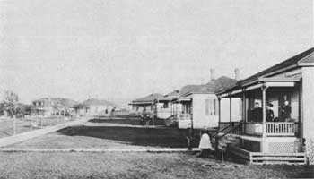 |
| Officers' row, Fort Meade, in 1889. (photo John C. H. Grabill, Library of Congress) |
 |
FORT RANDALL South Dakota |
 |
| ||
This strategic Missouri River fort (1856-92), almost astride the South Dakota-Nebraska boundary and not far west of Iowa and Minnesota, played an outstanding role in many of the events on the northern Plains in the last half of the 19th century. Its activities ran a broad gamut: Indian control and protection of settlers, keeping the peace between warring tribes and factions occupying the various reservations in the area, and the supply of posts on and policing of the upper Missouri River. The fort hosted such prominent Indian fighters as Custer, Sheridan, Sully, Sherman, and Terry. It was also a base for Brig. Gen. Alfred Sully's expeditions in 1863-65 against the Sioux in the Dakotas following the 1862 uprising in Minnesota. And in the years 1881-83 Sitting Bull was imprisoned at the fort, to which he was transported by steamer from Fort Yates following his surrender at Fort Buford, N. Dak.
The wide-ranging activities of the garrison reflected the fort's diverse responsibilities and involved participation in such endeavors as: the reprisals against Chief Inkpaduta following the Spirit Lake Massacre, Iowa (1857); the Mormon Expedition (1857-58), to Utah; the Corps of Engineers expedition (1859), under Capt. William F. Raynolds, that explored the Yellowstone River and its tributaries; the Yellowstone Survey Expeditions of 1872 and 1873, surveying the route of the Northern Pacific Railroad; the attempts to exclude miners from the Black Hills after Custer's reconnaissance in 1874; the warfare that subsequently broke out with the Sioux and Cheyennes because of the illegal violation by miners of the Great Sioux Reservation; and, with the remaining units of the 7th Cavalry, the disarming of the Hunkpapa Sioux at the Standing Rock Reservation, N. Dak.-S. Dak., in September 1876 after the Custer disaster.
Fort Randall, whose site is under the jurisdiction of the U.S. Army Corps of Engineers, is one of the few of the large number of prehistoric and historic sites in the area running upriver along the Missouri to Big Bend spared by the waters of the Fort Randall Reservoir. The only surviving remain above ground is the roofless and windowless cross-shaped chapel, Christ Church (1875), which also served as a library and lodge meeting hall. Its unstabilized and still-impressive cut-stone native masonry ruins, of interesting architectural design, have somehow survived vandalism and years of exposure to the elements. A few ancient and battered cottonwood trees grow along the parade ground, which is outlined by crumbling and brush-covered masonry foundations and cellar walls. The post cemetery, on a nearby hillside, today contains only a few civilian burials.
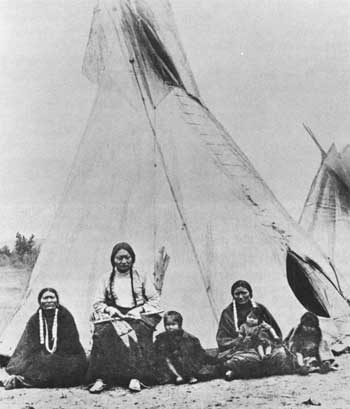 |
| Sitting Bull, with two of his wives and some of his children, while imprisoned at Fort Randall. (Smithsonian Institution) |
 |
FORT SISSETON South Dakota |
 |
| ||
Founded in 1864 by Wisconsin and Minnesota Volunteers during the Civil War not far west of the Minnesota boundary in the northeastern corner of South Dakota, this fort was known as Fort Wadsworth until 1876. The Army established it to assure settlers, fearful even though the campaigns of Sibley and Sully in 1863-64 had pacified most of the Sioux in the region. The local Sisseton and Wahpeton Sioux were friendly; and on the basis of an 1867 treaty agreement, in the 1870's they were placed on a reservation adjacent to the fort. Besides controlling the Indians, it protected emigrants traveling the wagon routes to the Idaho and Montana goldfields; aided railroad surveyors; and, a hub of civilization on the frontier and a policing agency before the establishment of civil courts, was a stabilizing influence on settlement. In 1889 the Army transferred the fort to the State.
The State has carried on the restoration and repair program inaugurated in 1932 by a local citizens' group to replace buildings that had been torn down or fallen into ruins during the previous four decades, when it had been leased to ranchers and sportsmen. In the years 1935-39, utilizing Works Progress Administration (WPA) labor, the National Park Service continued the project. As a result of all these efforts, Fort Sisseton State Park contains an extensive and architecturally interesting complex of 16 major stone and brick buildings, which over the years had replaced the original log structures. Now in varying stages of restoration and repair, they suffer from few modern intrusions.
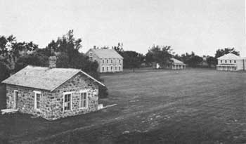 |
| Modern appearance of Fort Sisseton. Clockwise, adjutant's office, commanding officer's quarters, doctor's quarters, and hospital. (South Dakota Division of Parks and Recreation) |
 |
PINE RIDGE AGENCY South Dakota |
 |
| ||
This agency was the focal point of the Sioux Ghost Dance rebellion in 1890 and the ensuing military operations. These culminated in the Battle of Wounded Knee, in which the Army crushed the Sioux. Following the Battle of the Little Bighorn, the Army launched a series of drives in Wyoming and Montana and in 1876-77 forced practically all the hostile Sioux onto the Great Sioux Reservation. In 1876 their more peaceful reservation brethren, in the Black Hills Treaty, had ceded to the United States the Powder River hunting grounds of Wyoming and Montana; the Black Hills; and the rest of the western part of the Great Sioux Reservation, which under the Fort Laramie Treaty (1868) had embraced roughly the entire western half of South Dakota. The Indians also agreed to relinquish all land outside the Great Sioux Reservation; included were their two agencies in Nebraska.
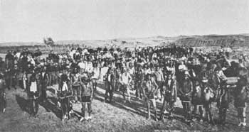 |
| Troops from Camp Cheyenne, S. Dak., mingling with Miniconjou Ghost Dancers in the autumn of 1890. (photo John C. H. Grabill, Library of Congress) |
As a result, in 1877 the Indian Bureau relocated the Red Cloud and Spotted Tail Agencies from northwestern Nebraska to sites along the Missouri River in South Dakota, the Red Cloud Agency a few miles north of its junction with the White River and the Spotted Tail Agency just north of the Nebraska boundary. About 800 of the 13,000 Indians on the march escaped to Canada and the rest refused to travel as far as the new agencies. The Oglalas of the Red Cloud Agency chose to settle along White Clay Creek, S. Dak., and the Upper Brules of Spotted Tail Agency just to the east along the east fork of the White River. The next year, 1878, the Indian Bureau bowed to Indian intransigence and relocated the agencies westward to the area in which the tribes resided and renamed them, respectively, Pine Ridge and Rosebud. As part of the same overall consolidation of the Sioux in 1876-78, the Miniconjous were settled on the Cheyenne River Reservation, S. Dak.; and the Hunkpapa, Yankton, and Blackfeet Sioux at the Standing Rock Reservation, N. Dak.-S. Dak., adjoining the Cheyenne River Reservation on the north.
All the Sioux, nomadic tribes who found adjustment to an alien civilization in the harsh reservation system exceedingly difficult, began to dream of a miraculous return to their former way of life. They were thus receptive to the Ghost Dance religion of the Nevada Paiute Wovoka. In the winter of 1889-90, 11 Sioux delegates—eight from Pine Ridge; two from Rosebud, one of whom was Short Bull; and one, Kicking Bear, from the Cheyenne River Reservation—visited Wovoka in the Mason Valley of Nevada. They returned to their reservation in the spring with glowing reports of the new religion. But the Indian agents at Pine Ridge and Rosebud repressed their attempts to introduce it among their tribesmen, and those at the Standing Rock and Cheyenne River Reservations at the time evinced slight interest in Wovoka's doctrines.
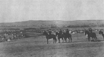 |
| General Miles and staff viewing Indian encampment near Pine Ridge Agency in January 1891. (photo John C. H. Grabill, Library of Congress) |
By summer, conditions at the reservations had so worsened that they presented a fertile environment for the religion's spread. Indian grievances included a large reduction in the Great Sioux Reservation in 1889; hunger, resulting from a curtailment of Government rations caused by a cut in appropriations; a drought in the summer of 1890; the onslaught of measles and other diseases highly fatal among the children; and the corruption or ineffectiveness of some Indian agents, who had continual jurisdictional disputes with the Army.
Thus, in itself the Sioux adoption of the essentially pacifistic Ghost Dance religion would probably not have generated the conflagration that ensued. The problem was that it was in reality a symptom of profound unrest stemming from tangible complaints. In their bitterness, the Sioux added to it militance and hatred of the whites. The displays of unbridled emotions expressed in the wild dance, which climaxed in ecstatic illusionary trances, alarmed the Indian agents and settlers in the region. The Sioux responded to the repressive measures of the agents by arming themselves against possible intervention and launching a vigorous defense of the religion that turned into a virtual holy crusade. Religious fanaticism made peaceful control of the restless warriors difficult and a few clashes resulted. By September and October many Indians on the Cheyenne River, Standing Rock, Rosebud, and Pine Ridge Reservations were in a state of wild excitement and rebelliousness. The apprehensive Indian agents and settlers in the region began to request military aid.
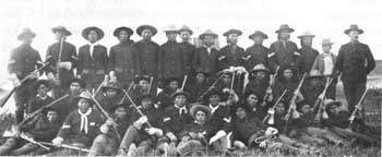 |
| Lt. John J. ("Black Jack") Pershing and troop of Oglala scouts at Pine Ridge Reservation in 1891. Pershing later won fame in World War I. (Denver Public Library, Western Collection) |
At Pine Ridge, particularly, conditions were chaotic. There the lot of the Sioux had long been especially unhappy and relations with the Indian Bureau had been characterized by dissension and animosity. In the years 1879-86 Indian Agent Valentine T. McGillicuddy and the Oglala Chief Red Cloud had clashed regularly. The chief strenuously resisted the educational program in farming, attempts to diminish the paramount position of tribal chiefs, and the imposition of the scores of other social and religious changes that spelled doom to the old way of life. Relations were smoother during Hugh D. Gallagher's regime (1886-90), but resentment continued, and in 1890 the reservation became a center of the Ghost Dance religion. On October 9, at a time when the religious frenzy of the Oglalas and Brules was at a peak, a new and inexperienced agent, Daniel F. Royer, replaced Gallagher. Royer proved to be the catalyst. Frightened and completely unable to cope with the situation, 4 days after his arrival he dispatched a frantic plea for military protection.
On November 20 the first contingents of troops, from Omaha and Forts Robinson and Niobrara, Nebr., arrived at the Pine Ridge and Rosebud Reservations. By the end of the month thousands more from all the surrounding States had arrived on the scene—nearly half the Army's infantry and cavalry and some artillery, the largest concentration of troops anywhere in the United States between the Civil War and the Spanish-American War and one of the largest ever assembled in one place to confront Indians. At Pine Ridge, Maj. Gen. Nelson A. Miles, commanding the operation, converged his greatest force, which totaled about 3,000 and included the entire 7th Cavalry Regiment, under Col. James W. Forsyth.
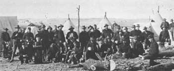 |
| These infantrymen at Pine Ridge were part of the force that massed in the region prior to the Battle of Wounded Knee. (Denver Public Library, Western Collection) |
At the appearance of the troops, Kicking Bear and Short Bull and 3,000 Ghost Dancers fled to the badlands about 50 miles northwest of the Pine Ridge Agency, at the northwest corner of the Pine Ridge Reservation. Although this action was not hostile, General Miles decided to remove from the reservations and incarcerate the most conspicuous agitators. Prominent among them was Sitting Bull, Custer's nemesis, who allegedly was fomenting a rebellion at his camp on the Standing Rock Reservation. His death while resisting arrest on December 15, and the flight of his followers southward contributed to the events that led, 2 weeks later, to the Battle of Wounded Knee.
Pine Ridge is still the agency of the Oglalas. Although a few of the buildings date from the turn of the century, most are of recent origin.
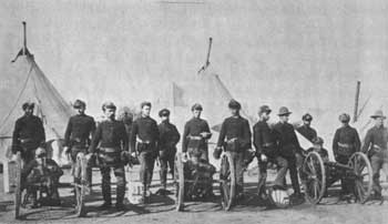 |
| Part of the artillery detachment that took part in the Battle of Wounded Knee at Pine Ridge in January 1891, a month after the battle. The Hotchkiss guns had rained deadly fire on the Indians. (photo John C. H. Grabill, Library of Congress) |
 |
ROSEBUD AGENCY South Dakota |
 |
| ||
The successor of Spotted Tail Agency in controlling the Brule Sioux, this agency originated at the same time and for the same reasons as Pine Ridge, which adjoined it on the west. Although conditions on the Rosebud Reservation were not much better than at the other Sioux reservations, Rosebud experienced less strife than most of them and certainly less than Pine Ridge. The main reason was that the Brules had no strong leader; in 1881 an other Indian had killed Chief Spotted Tail. But the competition among those who sought to succeed him sometimes resulted in near-anarchy. Many of the Brules became Ghost Dancers in 1890, but they participated chiefly at the Pine Ridge Reservation, the center of the religion and the scene of its subsequent military repression.
The Brule agency is still headquartered in the town of Rosebud, whose buildings are nearly all of 20th-century origin.
 |
SLIM BUTTES BATTLEFIELD South Dakota |
 |
| ||
At this site north of the Black Hills the Sioux suffered one of their first setbacks in the wake of their defeat of Custer in June 1876. Brig. Gen. George Crook's force, after separating from Terry's command in August, was en route to the hills to obtain supplies. On September 8 Capt. Anson Mills, leading the advance guard, came upon a band of Sioux under American Horse camped at Rabbit Creek near Slim Buttes. Although greatly outnumbered, the troops charged, captured the village, and held out until the main body came to their aid. Crazy Horse and his braves, not far away, tried to help American Horse, but they arrived too late. American Horse and several of his men, trapped in a cave, surrendered when the chief received mortal wounds. Casualties were not great on either side. But the Army continued its pursuit of the survivors and other fugitives. In the autumn many of them, tired of the pursuit and facing the rigors of winter, slipped back to the agencies to surrender. The others were to endure months of insecurity as soldiers braved winter perils to pursue them.
The site is located on an unbroken prairie surrounded by pine-dotted hills. A monument and several markers stand on a small hill near the highway.
 |
 |
http://www.cr.nps.gov/history/online_books/soldier-brave/sitec15.htm
Last Updated: 19-Aug-2005