


Survey of Historic Sites and Buildings
 |
FORT DALLES Oregon |
 |
| ||
Fort Dalles (1850-67) was strategically located at the Dalles of the Columbia. Troops from Columbia Barracks (Fort Vancouver) founded it, utilizing a temporary stockade that had been erected near abandoned mission buildings just before the beginning of the Cayuse War (1848). By 1852 a town had grown up around the fort. Headquarters for central and eastern Oregon, the fort protected the Oregon Trail and served as a key outpost and supply base during the Indian troubles of the 1850's, especially the Yakima War (1855-56), in eastern Washington. Resenting the invasion of settlers and miners into the region that followed the cession of a large part of their lands to the U.S. Government in 1855, the Yakimas and allied tribes, spurred by the Yakima chieftain Kamiakin, disavowed the treaties and retaliated. Col. George Wright's campaign with a force of infantry Regulars brought the war to an end. Some troops stayed at Fort Dalles in the Civil War era, but they marched out in August 1866. Others returned temporarily in December and remained until the next July, during which time Crook's troops used the post for his Snake campaign (1866-68).
The only surviving building, at the southwest corner of 15th and Garrison Streets, is the frame surgeon's quarters (1857), an excellent example of Gothic Revival architecture. Owned by the Oregon Historical Society, it is operated as a museum by the Wasco County-Dalles City Museum Commission. The parade ground is located on the site of a private school at 14th and Trevitt Streets.
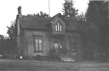 |
| Surgeon's quarters, Fort Dalles. (National Park Service) |
 |
FORT HARNEY Oregon |
 |
| ||
Founded in 1867 in southeastern Oregon by General Crook as a temporary base during his 1866-68 Snake campaign and the scene of the treaty-signing ending it, this fort later became a permanent fortification to protect settlers from Indians. It provided minor support during the Modoc War (1872-73) and was a base and refuge for settlers during the Bannock War (1878), which spilled over from Idaho into Oregon. More than 500 Indians were imprisoned at the fort prior to being moved to a reservation in January 1879. The last troops left the next year.
Nothing remains of the log and frame fort except the cemetery, on privately owned property. It now contains only two civilian graves. The ghost town of Harney City, 2 miles to the south, also in private ownership, had boomed after the fort was inactivated.
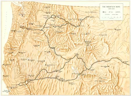 |
| The Mountain Wars (1850-1880) (click on image for an enlargement in a new window) |
 |
FORT HOSKINS Oregon |
 |
| ||
This small post (1856-65) was established in west-central Oregon at the eastern entrance to the Siletz Indian Reservation, where the U.S. Government concentrated the Rogue River Indians at the end of the second Rogue River War (1855-56). With nearby Fort Yamhill, it guarded the reservation and protected settlers from further depredations. To provide security for the Indian agency, the fort commander built and garrisoned a blockhouse adjacent to it. A road, built under the supervision of Lt. Philip H. Sheridan, connected the fort and blockhouse. During the Civil War, California Volunteers replaced Regular troops.
The 126 acre Fort Hoskins Park property is located west of the community of Kings Valley in the upper Luckiamute River Valley. Originally the site of historic Fort Hoskins (1856–1865), the property is now largely wooded and undeveloped, with an old farmhouse (circa 1870) and the ruins of several farm buildings and a schoolhouse. The property was purchased by Benton County for a park site in 1991.
 |
FORT KLAMATH Oregon |
 |
| ||
Protection of settlers in the Klamath Basin from Modoc, Klamath, and Shasta Indians was the reason for founding this fort (1863-89). Some of these Indians allied with the Northern Paiutes (Snakes), against whom Crook campaigned in 1866-68. The fort played a major role in the Modoc War (1872-73). The troops that sparked the war by trying to force the Modoc leader Captain Jack and his band back onto the Klamath Indian Reservation, Oreg., set out from Fort Klamath. During the ensuing engagements, it was the principal supply and replacement depot and medical receiving station. After his surrender in June 1873, Captain Jack and his followers were imprisoned in a specially constructed stockade at the fort, where he was tried and hanged in October along with three of his lieutenants.
All traces of the fort have disappeared. The site, now part of a ranch, is marked by a stone monument.
 |
FORT LANE Oregon |
 |
| ||
In the shadow of majestic Lower Table Rock on the south bank of the Rogue River, this small fort was founded at the conclusion of the first Rogue River War (1853) and figured prominently in the second (1855 56). Near Lower Table Rock, in August 1853, troops won the final victory of the first war; a few weeks later, near the rock, the peace treaty was signed. The second war, like the first, was predominantly a Volunteer effort against elements of the Rogue River, Shasta, Umpqua, and other tribes. Resenting the intrusion of settlers and miners, they had strayed from the Table Rock (Rogue River) Reservation, to which they had been assigned at the end of the first war, and had aroused the wrath of settlers. During the ensuing hostilities, the handful of dragoons at Fort Lane were too few to offer much help to the Volunteers and 288 Regulars under Maj. Robert C. Buchanan that General Wool fielded in March 1856. Many nonparticipating Indians took refuge at Fort Lane. At war's end, the captives and their kinsmen were gathered there and most of them shipped to the Siletz Indian Reservation, Oreg. The fort's short history came to an end.
No remains of the log and mud post have survived. The site, on privately owned pastureland, is indicated by a stone marker, about 200 yards away.
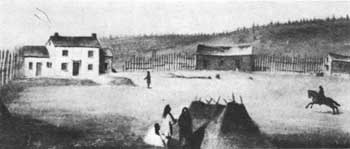 |
| The Dalles (Wascopam) Mission in 1849, some 2 years after its abandonment. Painting by William H. Tappan. (Bancroft Library, University of California) |
 |
THE DALLES (WASCOPAM) MISSION Oregon |
 |
| ||
This mission, founded among the Wascopam Indians in 1838 by the Reverends Daniel Lee and H. K. W. Perkins, was the second Methodist and the fourth Protestant mission in Oregon country. Its predecessor was the Willamette (Lee) Mission, founded by Jason and Daniel Lee 4 years earlier. The new site was located along the Oregon Trail on the south bank of the Columbia River at the western end of the Dalles, a series of falls and rapids interrupting river navigation. This spot was an old rendezvous for traders and Indians. Until 1846 it was a major stopping place at which wagon trains transferred to rafts to continue downriver. After the completion of the Barlow Road that year, most of the emigrants shifted to it and the Dalles declined in importance.
The missionaries at first preached from what came to be known as Pulpit Rock. The rock was near a spring, rich soil, and abundant timber. Adjacent to the rock the missionaries constructed several log buildings, including a dwelling house; three more structures, one used as a school; and outbuildings. Three years later a Catholic mission opened close by. As in the Willamette Valley, the Methodist efforts at the Dalles failed because of the disinterest of the local Indians in Christianity. In 1847 the Methodist Mission Society sold The Dalles Mission, its last active post in the Oregon country, to the American Board of Commissioners for Foreign Missions. Dr. Marcus Whitman, representing the board, placed his nephew, Perrin B. Whitman, in charge of The Dalles Mission, but he departed in December, the month after the Waiilatpu Massacre. That same month Volunteer troops occupied the site. During the Cayuse War (1848), they constructed a stockade. In 1850 the Army utilized it to found Fort Dalles. By that time the Catholic mission had also been vacated. The settlement of The Dalles soon grew up around the fort.
Although nothing remains of The Dalles Mission, Pulpit Rock, at 12th and Court Streets, is a well-known natural feature. A granite marker, in a triangular plot at 6th and Trevitt Streets, commemorates the mission.
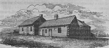 |
| Willamette (Lee) Mission, at its first location (1834-40), in 1841. Lithograph by one of the artists on the Charles Wilkes Expedition (1838-42). (Bancroft Library, University of California) |
 |
WILLAMETTE (LEE) MISSION Oregon |
 |
| ||
In October 1834 the Methodist ministers Jason Lee and his nephew Daniel Lee founded this mission, the first established by any denomination in the Oregon country. It was originally located on the east bank of the Willamette River near the agricultural settlement of French Prairie, founded by ex-Hudson's Bay Co. employees. The Lees made little progress in educating and converting the local Indians, who were plagued with sickness and disease. Undaunted and envisioning an extensive missionary-colonization program in Oregon, in 1838 Jason sent Daniel and another missionary to found The Dalles branch mission and returned to the East to collect funds and recruit missionaries and settlers.
In 1840 Jason moved the Willamette Mission to a more favorable location 10 miles to the south, at the site of Salem, where waterpower was available. Shortly thereafter, 50 recruits arrived. Most of them stayed in the vicinity of the mission, but concentrated on rather than trying to further the mission's cause. A few left, however, to establish branches at Willamette Falls, Clatsop Plains, and Fort Nisqually. By 1842 the party had completed a gristmill, sawmill, home for Jason Lee, Indian school, and parsonage to house teachers. Despite this progress, word of Lee's failure among the Indians reached the Methodist Mission Society, which in 1843 suspended him. The next spring he returned East. That same year the society sold its property at both sites to settlers. A prosperous agricultural settlement called Chemeketa, later Salem, soon grew up at the second site.
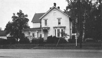 |
| Jason Lee House, now being restored. (National Park Service) |
The site of the first Willamette Mission, of which nothing remains, is today a Marion County park, located a half mile south of the Wheatland Ferry. A bronze plaque mounted on a large boulder marks the general location of the mission. Of the second mission, two 2-1/2-story frame structures, built in 1841-42, are extant in Salem. The mission parsonage, not at its original location, is temporarily located on 13th Street. Jason Lee's home, 960 Broadway, is privately owned and has been extensively altered.
 |
 |
http://www.cr.nps.gov/history/online_books/soldier-brave/sitec14.htm
Last Updated: 19-Aug-2005