


Survey of Historic Sites and Buildings
 |
BIG MOUND BATTLEFIELD North Dakota |
|
| ||
The Battle of Big Mound was one of the key engagements in Gen. Henry Hastings Sibley's 1863 expedition from Fort Ridgely, Minn., against the Santee Sioux who had sparked the uprising in the Minnesota River Valley the previous year. Eluding his troops, they had fled to Dakota and joined forces with the Tetons. On July 24 Sibley surprised about 3,000 Sioux, consisting of friendly Sissetons and Inkpaduta's hostiles, who were hunting buffalo near Big Mound. During a parley one of Inkpaduta's warriors shot and killed a military surgeon, Dr. Joseph Weiser. In a running battle the Indians fought tenaciously to protect the retreat of their families but 13 died. Following this victory, Sibley and General Sully won a series of triumphs over the Sioux.
This 50-acre site, also known as the Burman and Camp Whitney sites, is used for ranching. It is all in private hands except for a small tract owned by the State. The slightly rolling terrain, covered with prairie grass and dotted with lakes, is but slightly impaired. A stone marker, on a cairn of rocks, indicates the spot of Dr. Weiser's death and the beginning of the battle.
|
FORT ABERCROMBIE North Dakota |
|
| ||
Fort Abercrombie (1858-77) was the first Army post in present North Dakota and one of the earliest in the region. Situated on the west bank of the Red River at the head of navigation, it protected river traffic, travelers, and settlers. Logistical gateway to the largely unexplored plains of the old Northwest, it was the jumping-off place for prospectors proceeding over the northern route to the Montana and Idaho goldfields, as well as emigrants and troops. The main road was the Fort Totten Trail, pioneered in 1862-63 by Capt. James L. Fisk and extending from Fort Snelling, Minn., via the North Dakota forts of Abercrombie, Totten, Stevenson, and Buford to Fort Benton, Mont.
Fort Abercrombie also played a peripheral role in the Santee Sioux uprising of 1862, which spilled over from Minnesota into the Dakotas. In the latter part of August the Sioux attacked settlers in the Red River Valley and many of them took refuge at the fort. On September 3-6 several hundred warriors besieged it, and on September 26 reinforcements from Fort Snelling helped the garrison of Minnesota Volunteers beat off another assault. The 1862-64 campaigns of Generals Sully and Sibley in Minnesota and the Dakotas quelled the rebellion and encouraged the spread of settlement in the area.
Fort Abercrombie State Historic Park includes a small museum. A paved highway bisects the parade ground and divides the park into two tracts. The only original remaining structure is the frame guardhouse. The palisaded stockade and other buildings, built of wood except for the brick magazines, have long since disappeared. A large stockade and three blockhouses have been reconstructed. A marker near the guardhouse indicates the site of a barracks.
|
FORT ABRAHAM LINCOLN North Dakota |
|
| ||
Lt. Col. George A. Custer commanded this post in the years 1873-76. It was the base for his 1874 expedition into the Black Hills, in the wake of which miners poured into the region and inflamed the Sioux. In the ensuing campaign against them, he and the 7th Cavalry set out from the fort with Brig. Gen. Alfred H. Terry's column in 1876 on their ill-fated expedition to the Little Bighorn. After the debacle, Terry returned to it, as did also the wounded survivors of Custer's regiment in the steamer Far West.
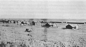 |
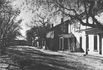
| Fort Abraham Lincoln in the 1870's. (Minnesota Historical Society) |
The predecessor of the fort was a stockaded infantry post called Fort McKeen, founded in June of 1872 on the west bank of the Missouri across from the site of Bismarck, N. Dak., and moved in August about 5 miles to the south on the river bluffs. In November Fort Abraham Lincoln, a cavalry base activated on the plain to the southeast, absorbed Fort McKeen. In time it grew into a major Army post. Its troops accompanied the Yellowstone Survey Expedition of 1873, the last of three expeditions surveying the route of the Northern Pacific Railroad; and later protected construction workers.
During 1877 the garrison participated in the Montana campaign against the Nez Perces. When they surrendered in October, it helped escort them from Fort Keogh, Mont., to Bismarck, N. Dak., en route to Fort Leavenworth, Kans. By the end of the 1880's the railroad had been completed, most of the Indians had been confined to reservations, and local settlers were numerous. The Army evacuated the fort in 1891, by which time it was already falling into ruins and being dismantled by settlers.
Fort Abraham Lincoln State Park includes the sites of the two forts and several restored Mandan Indian earth lodges. The locations of numerous buildings have been marked. Three blockhouses at Fort McKeen have been reconstructed. The original flag pole of Fort Abraham Lincoln stands in front of the Custer House marker. Only the foundations remain of this 10-room home, where Custer lived while commanding the post. A museum interprets the fort's history
 |
| Officers of the 7th Cavalry and their ladies at Fort Abraham Lincoln shortly before the regiment departed for the Little Bighorn campaign. Custer is third from the left, and his wife is the first lady from the left on the lower step. (National Park Service) |
|
FORT BUFORD North Dakota |
|
| ||
Barely able to cope with Indian depredations along the Bozeman Trail, in 1866-68 the Army established a chain of forts along the Missouri River, the other major route to the newly discovered Montana goldfields. One of the new posts was Fort Buford, founded in 1866 near the confluence of the Yellowstone and Missouri Rivers in hostile Indian territory. A leading Army bastion in the Dakotas and the northern Plains region, it was a supply center and base for campaigns against the Indians in the area. Its troops also settled many of them on reservations, distributed annuities, and policed the region to restrain traders illegally bartering ammunition and whisky with the Indians for pelts. Prominent Army officers who visited the fort at one time or another include Sherman, Sheridan, Custer, Miles, and Pershing.
In 1866, while Red Cloud was plaguing the Bozeman Trail in Wyoming and Montana, Sitting Bull harassed the troops who were hastily constructing Fort Buford, a one-company post, enlarged the next year to a five-company installation with materials salvaged from the nearby Fort Union trading post. Although Buford was never directly assaulted and suffered few casualties, for the first 4 years it was under continual siege. The Indians raided woodcutting, hunting, and haying parties; rustled livestock; and attacked mail coaches running between the post and Fort Stevenson, N. Dak.
Fort Buford figured prominently in the northern Plains campaigns of the 1870's and 1880's. A main logistical base for the campaigns against the Sioux and Cheyennes in Wyoming and Montana that followed the Custer defeat in 1876, it handled many of the men and supplies shipped up the Yellowstone and Missouri via wagon trains and boats.
The nontreaty Nez Perces, defeated in the Battle of Bear Paw Mountains, Mont., in 1877, following their exodus from Idaho, passed through Fort Buford en route from Fort Keogh, Mont., to Fort Leavenworth, Kans. The post was also the scene of the surrender of Sitting Bull and his followers. After they had crushed Custer's force, they had sworn they would never accept reservation restraints and had eluded the Army and escaped to Canada. Prevented from crossing the international boundary to hunt buffalo by U.S. patrols, unwanted by Canadian authorities, and suffering from the severe cold, the hungry and tired group, reduced in number by defections to about 1,300, straggled into Fort Buford in the spring and summer of 1881. From there they were moved to Fort Yates, N. Dak. Sitting Bull was escorted from there to Fort Randall, S. Dak., and imprisoned for 2 years.
Until the post's inactivation in 1895 the garrison kept busy sending out routine patrols, policing the international border to stop Indian movements in either direction, and furnishing troops to guard railroad construction workers. The fort buildings were sold at public auction and many of them were used in constructing the present town of Buford.
About 36 acres of the Fort Buford reservation are maintained as a State historic site, and an additional 160 acres are in non-State ownership. Two of the buildings have survived in their original location. One is a frame officers' quarters, which today serves as a museum. The other is the stone powder magazine, whose roof the State restored after a fire destroyed it. Some buildings have been shifted in location and altered for modern use. These include the morgue, until recently a farm residence; and a row of frame stable sheds, apparently constructed from materials in the old barracks and used in modern times as a barn and granary. Some foundations, possibly those of the hospital, are visible not far from the powder magazine. The soldier graves in the rehabilitated cemetery, south of the fort, have been moved and only civilian graves remain.
|
FORT RICE North Dakota |
|
| ||
Among the earliest of numerous Missouri River posts and the first on the river in North Dakota, this fort was founded in the summer of 1864 as a stockaded supply base by Brig. Gen. Alfred Sully during his 1863-64 expedition into the Dakotas against the Sioux who had been responsible for the 1862 Minnesota uprising. He used it again in his campaign the next year into the same region. Subsequently the primary mission of the fort was protection of river navigation, though in July 1868 it was the scene of the signing by some of the upper Missouri chiefs or their emissaries of the Fort Laramie Treaty (1868). Sitting Bull, who sent his chief lieutenant, Gall, and other chiefs refused to attend. Father Pierre Jean De Smet, special representative of the Peace Commission that negotiated the Fort Laramie Treaty, who had met with various chiefs of the region the previous year on behalf of the Government at Forts Rice, Sully, and Berthold, had persuaded the Indians to attend the 1868 council at Fort Rice. The three Yellowstone Expeditions of the 1870's (1871, 1872, and 1873), which escorted parties surveying the Northern Pacific Railroad, organized at the fort. The establishment in the early 1870's of Fort Yates, some 32 miles to the south, and Fort Abraham Lincoln, 25 miles to the north, brought about the inactivation of Fort Rice in 1878.
Fort Rice State Historic Site, comprising 7 acres, embraces a large portion of the fort area. The foundations of many of the original buildings, log and frame except for the stone magazine, have been marked. Two restored blockhouses stand on opposite corners of the parade ground.
 |
| Fort Rice in 1864. (Minnesota Historical Society) |
|
FORT TOTTEN North Dakota |
|
| ||
Located on the southeastern shore of giant Devils Lake, this fort (1867-90) was one of a group founded to protect the overland route extending across Dakota Territory from southern Minnesota to the goldfields of western Montana. Its second major mission was control of the surrounding reservation, formally established for the Cut Head, Wahpeton, and Sisseton Sioux in 1878 in accordance with an 1867 treaty. When the Army departed, the U.S. Government acquired the fort and adjacent lands, and used the buildings for an Indian boarding school into the modern period. In 1960 the Bureau of Indian Affairs transferred the bulk of the fort site to the State for historical purposes.
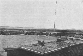
Fort Totten State Historic Park consists of the well-preserved post, almost unchanged since its establishment a century ago. Practically all of the brick buildings of the 1870's, numbering 15, remain. Although altered somewhat, mainly in the interiors, they are in excellent condition. They include officers' row, two-story duplex and multiplex family units; barracks; commissary store houses; and bakery. A museum is in the hospital building.
 |
| Officers' row, Fort Totten, as it appears today. (North Dakota Historical Society) |
|
FORT YATES and STANDING ROCK AGENCY North Dakota |
|
| ||
Standing Rock Agency (Grand River Agency II) was founded in 1873 near the sacred "standing rock" of the Sioux. It was the successor of Grand River Agency I (1868-73), located farther down the Missouri close to the mouth of the Grand River. Roughly the southern half of the Standing Rock Reservation, extending a few miles below the Grand River, was in north-central South Dakota. Adjoining it on the south was the Cheyenne River Reservation, S. Dak. Established in 1868 and guarded by Fort Bennett (1870-91), the latter stretched west of the Missouri River as far south as the Cheyenne River.
Fort Yates, N. Dak. (1874-1903), protected the Standing Rock Reservation, home of the Hunkpapa, Yankton, and Blackfeet Sioux. Together with the Cheyenne River (S. Dak.), Red Cloud (Nebr.), and Spotted Tail (Nebr.) Reservations, Standing Rock was a center of unrest during the Sioux troubles of the 1870's; in 1876 it furnished men and supplies to Sitting Bull's hostiles. In October 1876, following the Custer disaster and well before Sitting Bull departed for Canada, Brig. Gen. Alfred H. Terry marched down from Fort Abraham Lincoln, N. Dak., with a force of 1,200 men and disarmed and dismounted the reservation Indians at Standing Rock, as well as at the Cheyenne River Agency. As the fugitive Sioux capitulated, the Hunkpapas among them were sent to Standing Rock.
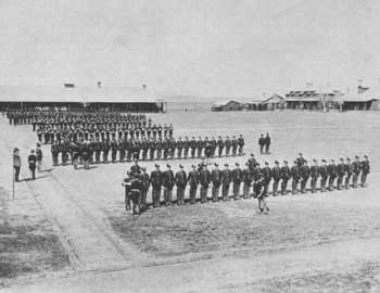 |
| Inspection at Fort Yates. Date unknown. (photo David F. Barry, Denver Public Library, Western Collection) |
After Sitting Bull's 2-year imprisonment at Fort Randall, S. Dak., following his surrender with his band in 1881 at Fort Buford, N. Dak., he returned to live with his people at Standing Rock Agency near his birthplace on the Grand River of South Dakota, about 40 miles south of Fort Yates and the Standing Rock Agency. Throughout the 1880's he resisted the efforts of the Indian Bureau to make farmers of his people and strip him of his authority. The Ghost Dance movement of 1890, in which he was a leading spirit, was strong on the Standing Rock Reservation but the Indian agent controlled it well. Nevertheless, at the peak of the Ghost Dance rebellion, Maj. Gen. Nelson A. Miles decided to arrest certain ringleaders. Accordingly, on December 15, 1890, James McLaughlin, the Standing Rock Indian agent, dispatched a detachment of 39 Indian police and four volunteers to apprehend Sitting Bull at his home. At first he submitted but then responded to his followers' opposition and resisted. One of his band shot a policeman and set off a scuffle, in which six of the police and eight Indians died, among them Sitting Bull and one of his sons. When cavalry reinforcements arrived to quiet the infuriated Hunkpapas, many of them fled southward toward the Cheyenne River and set off the grim chain of events that ended in the Battle of Wounded Knee.
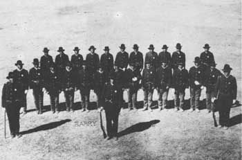 |
| Indian police at Standing Rock Reservation about 1890. Red Tomahawk, front center, killed Sitting Bull. (photo David F. Barry, Smithsonian Institution) |
No historic structures have survived at Fort Yates or Standing Rock Agency, around which the town of Fort Yates has grown up. Although Standing Rock is still a Sioux agency, the old frame buildings have given way to modern buildings. The sacred "standing rock" of the Sioux stands on a bluff above the Missouri at the northern end of town. The Indian police who died at the same time as Sitting Bull are buried in the town's Catholic Cemetery. Sitting Bull was buried in the post cemetery until 1954, when his body was moved to a Sitting Bull memorial overlooking the Oahe Reservoir near Mobridge, S. Dak. The reservoir has inundated the sites of the Cheyenne River Agency and Fort Bennett.
|
WHITESTONE HILL BATTLEFIELD North Dakota |
|
| ||
In the Battle of Whitestone Hill (September 3, 1863), the first of General Sully's two decisive victories in his 1863-64 Sioux campaign following the 1862 revolt in Minnesota, he dealt a heavy blow to Chief Inkpaduta. Surrounding Sully's advance guard, 4,000 Sioux confidently took advantage of the opportunity and applied battle paint. Sully used the time to bring up his troops. Some 300 braves died, and the troops captured 250 women and children. Army casualties were 22 deaths and 50 wounded.
Whitestone Hill Battlefield State Historic Site commemorates the battle. The natural terrain, low hills covered with prairie grass, has been only slightly disturbed. Around a monument in the center of the battlefield are 22 markers, each listing the name of a soldier who died. A small exhibit at a picnic shelter interprets the battle.
 |
 |
http://www.cr.nps.gov/history/online_books/soldier-brave/sitec12.htm
Last Updated: 19-Aug-2005