

Survey of Historic Sites and Buildings
 |
FORT BASCOM New Mexico |
 |
| ||
Founded on the south bank of the Canadian River in eastern New Mexico during the Civil War, Fort Bascom (1863-70) had a short but distinguished history. It helped control the Kiowas, Comanches, and other tribes inhabiting the Red and Canadian River region; watched over the Goodnight-Loving Cattle Trail, as well as the Santa Fe Trail; and policed the activities of the "Comancheros," American and Mexican renegades who traded illegally with the Indians. The fort fielded several expeditions against the southern Plains tribes. Col. "Kit" Carson led one of them, dispatched in 1864 by General Carleton because of harassment of the Santa Fe Trail. Carson clashed with a village of Kiowas in the Battle of Adobe Walls, Tex.
Fort Bascom was also the base of one of the three columns deployed by General Sheridan in his 1868-69 campaign. In November and December 1868 troops moved down the Canadian River; established a supply depot at Monument Creek; picked up a fresh southbound trail a few miles west of the Antelope Hills; pursued it vainly to the north fork of the Red River, then turned northward; and on Christmas Day won a resounding victory in the Battle of Soldier Spring, Okla.
At the time of the fort's abandonment in 1870, when the troops and stores were transferred to Fort Union, N. Mex., the poorly constructed post was still unfinished. It consisted of a sandstone officers' quarters and a few adobe buildings. No remains have survived. Permission must be obtained from the ranch owner to visit the site.
  |
FORT CRAIG New Mexico |
 |
| ||
This post's predecessor was Fort Conrad (1851-54), a motley group of adobe and cottonwood huts about 9 miles to the north, also on the west bank of the Rio Grande. Troops occupied Fort Conrad while they built Fort Craig (1854-84). The mission of the forts, near the northern end of the Jornada del Muerto (Journey of Death), was protecting westbound miners from Navajos and Apaches and guarding the Santa Fe-El Paso Road. The garrison, almost continuously occupied with defensive actions and patrols, took part in the Navajo and Apache conflicts of the 1850's and in the Apache wars (1861-86). Supported by troop remnants from abandoned posts in Arizona and New Mexico that had marshaled at the fort, it also fought in the nearby Battle of Valverde (February 1862), the first major battle of the Civil War in the Southwest.
The walls of 17 of Fort Craig's adobe buildings, in varying stages of disintegration, and the stone guardhouse are visible, as are earth mounds representing Civil War fortifications. The military cemetery is still surrounded by a stone wall but the burials, including those who died at the Battle of Valverde, were moved to Santa Fe in 1876. Nothing is left to indicate the site of Fort Conrad, on an unimproved road running east from I-25 (U.S. 85), about 5 miles north of San Marcial.
 |
FORT CUMMINGS New Mexico |
 |
| ||
 |
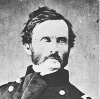
| Iron-fisted Gen. James H. Carleton, Civil War commander of the Department of New Mexico, won unprecedented victories against the Indians of the Southwest. (photo Matthew B. Brady, National Park Service) |
General Carleton's California Volunteers founded this fort in 1863 to guard strategic Cooke's Spring and the road to California. From 1858 until 1861 the site had been a Butterfield Overland Mail station, attacked by Apaches during the last year. Several expeditions and many patrols set out from the fort, some even pushing into nearby Mexico, but they made few contacts with the Indians. Abandoned in 1873, the post disintegrated. Between 1880 and 1886 it was reoccupied because of renewed Apache hostilities but the troops lived in tents outside the walls.
Remains of two officers' quarters, ruins of adobe walls, and earth mounds indicating foundations are located on privately owned ranchland. A plaque at the site, erected by the Daughters of the American Revolution, commemorates the Butterfield Overland Mail.
 |
FORT FILLMORE New Mexico |
 |
| ||
Along the Rio Grande not far from the Mexican border and a few miles southeast of the town of Mesilla, this tiny adobe fort was founded in 1851 to control local Apaches. By the end of the 1850's it had declined and fallen into disrepair. In 1861, however, spurred by rumors of Confederate invasion of New Mexico, the Army reinforced it. During July a force of 250 Texans took Mesilla. Failing in an attempt to liberate the town, the garrison abandoned the fort and marched toward Fort Stanton, N. Mex., but was captured east of Las Cruces. The next summer, California Volunteers temporarily occupied the post before moving into Mesilla.
The site of the fort, along a one-lane ranch road among sandhills about 1-1/4 miles east of N. Mex. 478, has been obscured by shifting sands. A State marker is located in the vicinity but not at the actual site.
 |
FORT MCRAE New Mexico |
 |
| ||
This fort (1863-76) was a small adobe post about 3 miles east of the Rio Grande and 5 miles west of the boundary of the Jornada del Muerto (Journey of Death). The Jornada was a desert valley about 90 miles long and 35 miles wide on El Camino Real (The Royal Road), for centuries the major New Mexico-Mexico traffic artery. Near the fort was the Ojo del Muerto (Spring of Death), one of the two watering places in the Jornada area. The Apaches used the spring and frequently ambushed travelers. After the massacre of a wagon train in March 1863, New Mexico Volunteers soon arrived in the area and founded Fort McRae. Shortly there after, California Volunteers occupied it. They sent out patrols; pursued hostile Indians, who often rustled the fort's livestock; and protected travelers on El Camino Real. In July 1866 Regulars took over the post.
Only foundation traces remain and lies submerged under Elephant Butte Reservoir.
 |
FORT SELDEN New Mexico |
 |
| ||
Situated on a slight rise overlooking the Rio Grande at the lower end of the Jornada del Muerto (Journey of Death), Fort Selden (1865-90) protected settlers in the Mesilla Valley and travelers on the El Paso-Santa Fe post road. The garrison, frequently harassed by Indians, took part in the campaigns against the Apaches until the fort's inactivation in 1877. In 1880, during the campaign against Geronimo, troops reoccupied it as a base to patrol the Mexican border.
Eroding adobe walls of some 25 buildings stand as high as 10 feet or more. A New Mexico historical marker on U.S. 85, from which the fort is visible, provides a brief sketch of its history.
 |
FORT STANTON New Mexico |
 |
| ||
Originally consisting of two blockhouses surrounded by an adobe wall, this fort was founded in 1855 to control the Mescalero Apaches, whom the Army had rounded up, and was the agency for the tribe until 1861. In that year, the Union Army abandoned the fort, temporarily occupied by Confederates, and did not return permanently until the following year. Meantime the Mescaleros, freed from military restraint, had begun to raid throughout central New Mexico. During the years 1862-64 Col. "Kit" Carson's New Mexico Volunteers, after reactivating Fort Stanton, captured the Mescaleros, as well as the Navajos, who were marauding in Arizona and New Mexico. In 1862-63 Carson placed 400 Mescaleros on the newly established Bosque Redondo Reservation, guarded by Fort Sumner, and in 1864 jammed in an additional 8,000 Navajos. The next year the Mescaleros, resenting the numerically superior Navajos, fled.
Brought under control once again in 1871, the Mescaleros were reestablished on the Fort Stanton Reservation, where the Jicarilla Apaches joined them in 1883. Many of the Mescaleros became restless because of dissatisfaction with the agents, factional quarrels among themselves, and disputes with cattlemen. They alternately fled and returned until the reservation became a virtual replacement depot for hostile Apaches. In 1879 many joined Victorio's band of about 100, formed principally with recruits from the Fort Stanton Reservation. In January 1880, when Victorio reappeared from Mexico, troops attempted to disarm the agency Mescaleros, but 50 escaped and joined Victorio. His death at the hands of Mexican troops in October brought an end to the Mescalero outbreaks.
The Army abandoned the fort in 1896, and 3 years later the U.S. Public Health Service acquired it for use as a merchant marine hospital. Formerly a State sanitarium and a State Correctional facility, it is now managed by Fort Stanton, Inc. Many of the stone buildings, which in 1868 had replaced the original adobe, have been remodeled and are used as residences, wards, and offices. Including the commanding officer's house, officers' quarters, and barracks, they are grouped around the parade ground, whose southern end is covered with modern construction.
 |
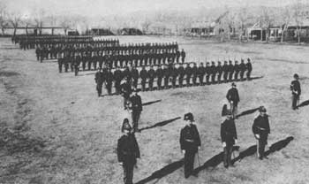
| Dress parade at Fort Stanton in 1885. (National Archives) |
 |
FORT SUMNER New Mexico |
 |
| ||
Fort Sumner was founded in 1862 at Bosque Redondo ("Round Grove of Trees") along the Pecos River in eastern New Mexico to guard the 400 Mescaleros and 8,000 Navajos conquered by Col. "Kit" Carson in 1862-64. In 1865 the Mescaleros, who detested the Navajos, fled. Three years later the U.S. Government commissioners who had earlier concluded treaties at Fort Laramie, Wyo., and Medicine Lodge, Kans., negotiated a treaty with the Navajos at Fort Sumner that allowed them to return to their ancestral homeland in northeastern Arizona. In the meantime, however, floods, drought, lack of skill, and Kiowa and Comanche raids had doomed all attempts at agriculture. Supplies and other necessities were scarce, and crowded conditions resulted in the spread of disease.
From 1866 through the early 1870's Fort Sumner was a way station on the Goodnight-Loving Cattle Trail. Herds wintered near the fort, and were sometimes purchased by the Government for issue to the reservation Indians. In 1869, the year after the Navajos departed, Fort Summer was demilitarized and put up for auction. The New Mexico cattle king Lucien Maxwell purchased it and remodeled some of the buildings for residential and ranching purposes. On his death, his son Peter inherited the property. In 1881 Pat Garrett shot and killed "Billy the Kid" in the house. A group of Colorado cattlemen bought the ranch in 1884, but their business collapsed a decade later.
The fort site is identifiable in a pasture on the east bank of the Pecos River, but in 1941 a flood washed away all traces of the adobe ruins. A guide is recommended, and permission to visit the site should be obtained from its private owner. A State marker is located at the junction of U.S. 60 and N. Mex. 212. A small cemetery behind a curio shop off N. Mex. 212 about a mile east of the fort site contains the grave of "Billy the Kid."
 |
FORT WINGATE New Mexico |
 |
| ||
This is the second site of Fort Wingate. The first fort (1862-68) was located at El Gallo, 65 miles to the southeast. Col. "Kit" Carson founded it along with Fort Canby, Ariz. (1863-64), for his 1863-64 campaign against the Navajos. After they were confined to the Bosque Redondo Reservation, adjacent to Fort Sumner, N. Mex., troops from the fort patrolled for stragglers and raiders. In a commanding position on the Albuquerque-Fort Defiance (Ariz.) Road, it also protected miners en route to the Arizona goldfields, and in 1864 took part in the Apache campaign along the Gila and San Carlos Rivers.
In 1868, when the Navajos returned to their homeland, the Army relocated Fort Wingate to its second site. This one was nearer the new Navajo Reservation, administered by the Fort Defiance Indian Agency. The site had previously been occupied by Fort Fauntleroy, or Lyon (1860-61), whose mission had also been Navajo control but which had been evacuated before the Confederate invasion of New Mexico from Texas. Besides policing the reservation, the garrison of the new fort participated in the Apache campaigns to the south. The Army withdrew in 1910, but in 1918 reactivated the fort as the Wingate Ordnance Depot. The depot moved in 1925 closer to the railroad, and a Navajo school took over the buildings.
Until its razing in the early 1960's and replacement with modern structures and school facilities, the fort was one of the best preserved frontier posts in the Southwest. A two-story barracks, rebuilt following a fire in 1896, is the only surviving major building. Constructed of stone, it has a two-level frame porch. No remains are extant of the first Fort Wingate. Its site is just off N. Mex. 53, about a mile west of San Rafael, in Valencia County.
 |
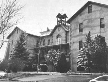
| Modern view of St. Catherine's Indian School. (National Park Service) |
 |
ST. CATHERINE'S INDIAN SCHOOL New Mexico |
 |
| ||
This school commemorates Catholic missionary efforts in the Southwest, particularly the humanitarianism of Mother Katharine. A Philadelphia banking heiress, Katharine Drexel (1858-1955) became a nun in 1889, and 2 years later founded the Order of the Sisters of the Blessed Sacrament for Indians and Colored People. Acquiring an interest in helping the Indians during her western travels in the 1880's, she had given liberal financial aid to the Bureau of Catholic Indian Missions, including money for St. Catherine's Indian School, built in 1886 and dedicated the next year. Catholic personnel operated the institution, supported by a Government subsidy, until 1893. The following year, Mother Katharine and nine members of her order arrived at Santa Fe from Philadelphia to manage the school. It served mainly the Pueblo Indians, but Navajos, Pimas, and Papagos also attended. Another institution Mother Katharine originated and financed, among the Navajos in 1902, was St. Michael's Indian School, just west of Window Rock, Ariz.
Both schools are still directed by the Sisters of the Blessed Sacrament. St. Catherine's has an enrollment of about 200. Structures dating from its early years, in use today, include the 3-1/2-story main classroom building, of adobe, and two other structures. St. Michael's, one of the largest Indian boarding schools in the Nation, has an attendance of about 400 Navajos, Hopis, Apaches, and Pueblos. A group of pitched-roof buildings from the 1910 era are the core of the modern school.
 |
 |
http://www.cr.nps.gov/history/online_books/soldier-brave/sitec11.htm
Last Updated: 19-Aug-2005