


Survey of Historic Sites and Buildings
  |
FORT BOWIE NATIONAL HISTORIC SITE Arizona |
 |
| ||
Few western forts have a more dramatic history than Fort Bowie (1862-94). Its eroding adobe walls today commemorate the soldiers who for over two decades endured the hardships and dangers of campaigns that rank among the most arduous and frustrating in military history; and Chiricahua warriors, masters of guerilla tactics and for two centuries obstinate defenders of their home land against the Spaniards, Mexicans, and Americans. The hub of military operations against the Chiricahuas, Fort Bowie was the base of the numerous expeditions fielded by Gens. George Crook and Nelson A. Miles that finally smashed the power of Cochise, Mangas Coloradas, Natchez, and Geronimo. Climate and topography aided the Indians, skilled at avoiding engagements where the odds were not overwhelmingly in their favor. For the soldiers, the Apache wars (1861-86) consisted chiefly of endless marches under the desert sun and only rare chances to come to grips with the foe.
Located in the Chiricahua Mountains near the eastern entrance of strategic Apache Pass, through which wound one of the major transcontinental trails, the post protected military and civilian traffic. The pass, whose history is closely interwoven with that of the fort, was a twisting defile between the rocky foothills of the Dos Cabezas and the Chiricahua Mountains. Its spring, a rarity in the semidesert country, enhanced its attractiveness as a route. Traveling by at various times were California-bound gold seekers, other emigrants, explorers, Mexican boundary commissioners, railroad surveyors, and troops.
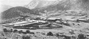 |
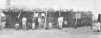
| Fort Bowie about 1890. (National Archives) |
Long before Americans began entering the region in the mid-19th century, the Indians and Spaniards had used the pass. In 1857 San Antonio-San Diego mail coaches temporarily traversed it. The following year the Butterfield Overland Mail, fixing its route between St. Louis and San Francisco via the pass, built a stone relay station and corral just west of the spring near the future site of the fort. The company's picturesque Concord stages operated through the pass until the outbreak of the Civil War, when the route was moved northward.
When the Americans arrived in the Apache Pass region, the Chiricahua Indians were residing there. Since the 17th century their homeland had been the Chiricahua Mountains just to the south and the Dragoon Mountains to the west. One of their chiefs was the youthful Cochise. Apart from occasional stage raids, he and his people were relatively amicable until February 1861. That month a young lieutenant, George N. Bascom, from Fort Buchanan, Ariz., attempted to arrest Cochise in the pass for a depredation he probably was not guilty of and caused blood to be spilled on both sides. The Bascom Affair enraged Cochise, who launched an all-out war on the Americans.
The alienation was untimely, for a few months later the outbreak of the Civil War brought about the withdrawal of many troops from the frontier. New Mexico and Arizona lay open not only to Indian attacks but also to Confederate invasion from Texas. When the Texans arrived in the summer of 1861, they learned that the Apaches did not distinguish between blue and gray. The Indians harassed the southerners until the following year, when Gen. James H. Carleton's California Volunteers drove the Confederates out of Arizona and New Mexico.
The Volunteers swiftly received an introduction to Apache warfare. In July 1862 about 500 Chiricahuas and Gilas, led by Cochise and Mangas Coloradas, ambushed a detachment in the pass. Only by employing artillery could the troops rout the braves from stone breastworks commanding the waterhole. To meet such threats to his line of communications through the pass with Tucson and California, Carleton ordered Fort Bowie built on a hill overlooking the spring and dominating the eastern entrance to the pass. The post consisted of hastily built breastworks enclosing a group of tents and a stone guardhouse. Although Carleton's aggressive policy decreased Indian hostilities in New Mexico, it did not intimidate Arizona's Apaches. Despite the frequent patrols sent out from the beleaguered Fort Bowie and other forts, by the close of the Civil War most of the ranches in the Tucson area and the town of Tubac had been deserted. Everywhere Apaches lurked in ambush. For 6 bloody years they continued to ravage southern Arizona.
 |
| Indian police in front of the San Carlos Agency guard house in 1880. (National Archives) |
In 1866, the same year the Government restored mail service between Tucson and Mesilla, N. Mex., Regulars replaced the Volunteers at Fort Bowie, and 2 years later moved it onto a plateau to the southeast of the original location.
To breathe new life into the Apache campaign, in 1871 General Crook assumed command of the Department of Arizona and stopped at Fort Bowie before proceeding to Fort Apache. But he was forced to suspend operations in southern Arizona while emissaries of President Grant's Peace Policy tried a conciliatory approach. One of them, Gen. Oliver O. Howard, succeeded the following year. At Cochise's Stronghold, in the Dragoon Mountains, he persuaded the Chiricahuas to settle on a newly created reservation at Sulphur Springs, whose agency was moved in quick succession from there to San Simon and Pinery Canyon and in 1875 to Fort Bowie. Meantime Crook, ignoring the Peace Policy, had crushed the Yavapais, or Apache-Mojaves, of central Arizona in the Tonto Basin campaign (1872-73), for which he used Camp Verde as a base. Whether coincidentally or not, peace with the Chiricahuas prevailed until Crook was reassigned in 1875, the year after illness took the life of Cochise.
Geronimo soon resumed raiding. In 1876, alarmed by the rash of hostilities, the Indian Bureau abolished the Chiricahua Reservation. Troops from Fort Bowie moved 325 Chiricahuas to the White Mountain (Fort Apache) Reservation, on the north of San Carlos, where the Apaches were being concentrated. But Geronimo and a group of recalcitrants, refusing assignment there, conducted a 3-year reign of terror. While the Chiricahuas were at peace in 1880 and 1881, Fort Bowie troops aided the drive against the Warm Springs Apache Victorio and his successor, Nana, in New Mexico. During the fall of 1881, however, a series of clashes occurred between Fort Apache troops, reinforced by those from Fort Bowie, and the White Mountain Apaches, who were aggravated by an influx of settlers and miners onto reservation lands. The Chiricahuas feared the Army would make no distinction between the innocent and the guilty. Geronimo, Natchez, and 75 warriors, avoiding pursuing columns, fled to Mexico's Sierra Madre and began 2 years of raiding on both sides of the border. Their numbers, swelled by newly recruited allies from the San Carlos Reservation, rose to 700. The U.S. Army and the Mexican troops guarded the waterholes and trusted that diligent pursuit and hardship would discourage the raiders.
In September 1882 Crook reassumed command in Arizona. Maintaining his field headquarters at Fort Bowie, he tightened discipline and reformed reservation management. Taking advantage of the agreement made by Mexico and the United States to permit their troops to follow Apaches across the international boundary, Crook employed large numbers of his Apache scouts, led by white officers, to ferret the Apaches out of the Sierra Madre. Convinced that the mountains no longer afforded sanctuary, in 1883-84 Geronimo and more than 300 of his followers returned to the San Carlos Reservation. But it continued to simmer with unrest, intensified by Indian Bureau-Army friction over reservation management.
After 2 years of comparative peace, in May 1885 Geronimo, Natchez, Nana, and 190 men once again fled into Mexico. The persistent Crook, though winning no major victories, eventually wore them down and in March 1886 they surrendered to him at Canon de los Embudos, Mexico. En route to Fort Bowie, however, most of them escaped to the Sierra Madre. Stung by the storm of public and official criticism that greeted this defection, General Crook asked to be relieved.
General Miles took over the next month. He revamped the supply system and, to improve communications, erected 27 heliograph stations on high peaks in Arizona and New Mexico, one on Bowie Peak. His newly organized "pursuing commands," possibly because of large reinforcements, quickly crushed Geronimo. His final surrender in September at Skeleton Canyon, Ariz., brought an end to the long and bitter Apache wars. At Fort Bowie special precautions were required to protect Geronimo and his fellow prisoners from the wrath of local settlers until they were moved to Fort Pickens, Fla. Their fellow Chiricahuas and some Warm Springs Apaches, including many scouts who had served Crook with distinction, had preceded them earlier in the year and had been sent to Fort Marion, Fla.
Until Fort Bowie was inactivated in 1894, the garrison merely rounded up Apaches who wandered from the reservation and investigated reports of depredations. Stagecoach service through Apache Pass had ceased with the advent of the railroad in the region in 1881.
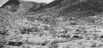 |
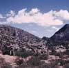
| Ruins of Fort Bowie. (National Park Service) |
Fort Bowie National Historic Site was authorized by Congress in 1964. An extensive restoration and interpretive program is planned. Today only rock foundations and adobe remnants mark the site of the original fort. Wall fragments and rock foundations of more than 40 buildings of the second dot the slope below Bowie Peak. The stone corrals are essentially intact, and remains of the water system are prominent. Well preserved traces of the stage route may be seen at various points in the pass, and a pile of rock rubble north of the fort cemetery and about 700 yards west of the spring marks the site of the Butterfield stage station. The historical setting of the fort and pass has been only slightly impaired by roads and ranching activity.
NHL Designation: 12/19/60
 |
 |
http://www.cr.nps.gov/history/online_books/soldier-brave/sitea3.htm
Last Updated: 19-Aug-2005