

Survey of Historic Sites and Buildings
 |
FORT LARAMIE NATIONAL HISTORIC SITE Wyoming |
 |
| ||
Fort Laramie, situated amid the rolling prairie of eastern Wyoming near where the Laramie River blends into the North Platte, was of outstanding significance in the history of the Rocky Mountain region and the West. From 1834 until 1890, it was a center of trade, supply-transportation, warfare, and diplomacy on the northern Plains. Its long and varied history epitomizes the successive stages by which Americans conquered and settled the immense territory stretching from the Missouri River to the Pacific. Through its gates passed trappers, traders, mountain men, overland emigrants, missionaries, adventurers, explorers, homesteaders, Mormons, forty-niners, and soldiers.
 |
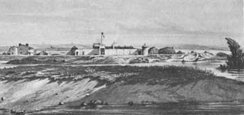
| Frederick Piercy's sketch of Fort Laramie in 1853. (National Park Service) |
Located in the buffalo country of the Sioux, during the period 1834-49 the fort was a major fur trading post and Indian-trader rendezvous. In the years 1834-41, it was also known as Fort William and Fort Lucien, a log stockade; and in 1841-49 as Fort John, an adobe, walled fort. From the 1840's until 1869, when completion of the Union Pacific Railroad augured the end of the covered wagon migrations, Fort Laramie was a key landmark and stopping point on the Oregon-California Trail; a division point on transcontinental stage and mail routes; a base for civil and Army freighters; and for a time a Pony Express relay station. As a military post during the period 1849-90, it protected emigrants and was closely associated with some of the treaties and many of the campaigns designed to pacify the northern Plains tribes. Its role in the fur trade, transportation-communications and the overland migrations will be treated in detail in the appropriate volumes of this series. The following discussion is limited to the last phase of the fort's history.
One of the largest posts in the West, Fort Laramie was active longer than most. Its strategic location made it an effective command headquarters and logistical-transport center for the many forts farther West and the troops that funneled in to man them or participate in the various campaigns. The fort originated as one of the first three posts founded by the Regiment of Mounted Riflemen to guard the Oregon-California Trail, the other two being the second Fort Kearny, Nebr. (1848-71), and Cantonment Loring, Idaho (1849-50) The increase in travel over the trail had demonstrated the need for military bases to serve as supply centers and provide protection from the Indians, who were venting their alarm over the stream of westbound caravans and the disappearance of grass and game from the vicinity of the trail by occasionally raiding wagon trains. As soon as the Mounted Riflemen purchased Fort Laramie from the American Fur Co. in 1849, the garrison inaugurated a building program, temporarily utilizing the existing adobe post. Within a decade, Fort Laramie became a sprawling military installation.
For the first half of that decade the Indians were relatively quiet, particularly after the Fort Laramie Treaty (1851), comparable to the Fort Atkinson Treaty (1853) with the southern Plains tribes. In the summer of 1851 one of the largest assemblages of Indians in the history of the West gathered around Fort Laramie—9,000 Sioux, Cheyennes, Arapahos, and Crows. Because of the better forage along Horse Creek, 35 miles to the east, the councils were held there. The Indians, in exchange for annuities, agreed not to raid the Oregon-California Trail or to war with one another and promised to permit the construction of military posts and roads.
 |
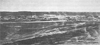
| Fort Laramie in 1876, at time of maximum occupation. (National Archives) |
An incident in the summer of 1854 shattered the comparative peace and marked the beginning of 3-1/2 decades of warfare between the Plains Indians and the Army. Not far from Fort Laramie, the Sioux reacted to the rashness of Lt. John L. Grattan, trying to arrest one of them for a minor offense, by annihilating his detachment and going on the warpath. Although seriously undermanned, the fort was not attacked by the Sioux and allied Cheyennes, who focused on stagelines and emigrant trains.
The tempo of assaults accelerated during the Civil War, when the fort's Regular garrison was withdrawn and the men available sometimes numbered less than 100. In the years 1864-67 the post commander maintained a small stockaded subpost, Fort Mitchell (Camp Shuman), Nebr., about 50 miles down the North Platte River just above Scotts Bluff. In the first half of 1865 the Sioux and Cheyennes launched a string of attacks on the Oregon-California Trail northwest of Fort Laramie.
The decade following the Civil War was a critical one. The campaigns of Generals Sibley and Sully in the years 1863-65 had inflamed the Sioux, Cheyennes, and Arapahos west of the Missouri River. Further aggravating them, in the summer of 1865 Brig. Gen. Patrick E. Connor led a 2,600-man force in three columns from Fort Laramie and Omaha into the Powder River country of Wyoming, partly in an attempt to still the public clamor for better protection of the Bozeman Trail. The Powder River Expedition marched long distances and endured many hardships. On the headwaters of the Tongue River one of the columns surprised and wiped out an Arapaho village. Otherwise, because of lack of coordination between the columns, the campaign failed dismally. By annoying but not intimidating the Indians, it aroused them to strike back.
The Bozeman Trail proved a tempting target, on which the Oglala Red Cloud and his allies intensified their assaults. In the summer of 1866 Red Cloud stormed out of a conference at Fort Laramie concerning use of the trail when troops marched in on their way to build a chain of protecting forts. Devastation followed in the region for 2 years, during which time Fort Laramie provided logistical and personnel support to the beleaguered Bozeman Trail forts of Phil Kearny, Reno, and C. F. Smith; and dispatched a relief expedition to Fort Phil Kearny after the Fetterman Disaster (December 1866).
The Fort Laramie Treaty (1868) ended hostilities for a time. Actually a series of generally similar but separate treaties with the northern Plains tribes, it was negotiated by the same Peace Commission that the previous October had concluded the Medicine Lodge Peace Treaties with the southern Plains Indians. Various northern Indian groups signed the treaty at Fort Laramie in April and May 1868, and those of the upper Missouri at Fort Rice, N. Dak., in July. But, frustrating the commissioners, Red Cloud did not sign until November, the month following the commission's disbandment, by which time the treaty's provisions had already been put into effect.
 |
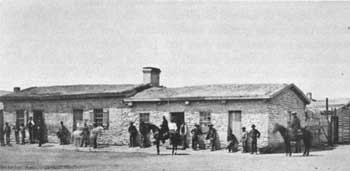
| The Fort Laramie post trader's store, hub of social and business activity, about 1875. (National Park Service) |
In the Fort Laramie treaties the U.S. Government and the northern Plains tribes declared peace. In the treaty with the Sioux the Government bowed to the demands of Red Cloud and other chiefs and agreed to close to white occupation and travel the Bozeman Trail region and the rest of an area designated for an indefinite period as "unceded Indian Territory." This territory embraced the area north of the North Platte River, east of the summits of the Bighorn Mountains, and in effect extending as far north as the Yellowstone River. The United States also granted the Sioux hunting privileges for an unspecified time in the region along the Republican Fork of the Smoky Hill River, in the lands north of the North Platte River, and in essence reaching northward to the Yellowstone River. In the hunting grounds the Sioux agreed not to obstruct white settlement, railroad construction, travel, or military operations.
Finally, the Government created for exclusive Sioux use in perpetuity the Great Sioux Reservation, roughly the western half of South Dakota beyond the Missouri River; and agreed to provide varied medical, educational, agricultural, and other facilities, as well as annuities and food. Relinquishing all claims to lands outside the Great Sioux Reservation, the Sioux agreed in time to settle down on it and live by agriculture rather than by hunting. The treaties with the Northern Cheyennes, Crows, and Northern Arapahos created reservations for each tribe or allowed its members to utilize existing reservations; and specified hunting grounds.
On the southern Plains the tribes initiated hostilities within a year of their signing the treaties of Medicine Lodge, but the Fort Laramie treaties brought for a time a considerable degree of peace on the northern Plains. It lasted until the 1875-76 mining invasion of the Black Hills, in the Great Sioux Reservation, infuriated the Sioux and Cheyennes and set off a war that lasted until 1877. During the Black Hills rush, hundreds of prospectors en route to the goldfields stopped at Fort Laramie, for a time a station on the Deadwood-Cheyenne stageline. In the extensive campaigns of 1876-77 the fort was a major base.
 |
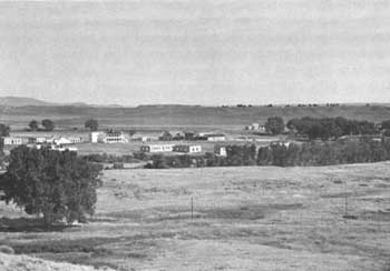
| Fort Laramie today. "Old Bedlam" dominates the scene. (photo Ray M. Littler, National Park Service) |
During the 1870's and 1880's ranchers began occupying the surrounding country and the post's mission changed. The garrison, helping to maintain law and order, apprehended cattle rustlers and highwaymen and escorted stages. Appropriately enough, the same year Fort Laramie was inactivated, 1890, the Census Bureau noted the passing of the frontier and the Army smashed the last Indian hopes for freedom in the Battle of Wounded Knee, S. Dak.
Fort Laramie National Historic Site preserves the surviving features of the military fort, and carries out restoration and archeological programs. The remains of 21 buildings and ruins may be seen. Some of the buildings have been restored or partially restored and many are furnished in the styles of different periods in the fort's history. Interpretive markers tell the story of extant buildings or foundations and indicate the sites of others.
The most historic building is the frame officers' quarters known as "Old Bedlam" (1849), which has been restored in its entirety, including the kitchen wings. The first military structure and the oldest standing military building in Wyoming, it was the scene of many gala affairs and long the administrative and social center of the post. Also significant is the post trader's store. It consists of adobe, stone, and lime-concrete sections, built between 1849 and 1883, and served at various times as a store, sutler's office, post office, officers' club, and enlisted men's bar. Other especially interesting structures are the lime-concrete lieutenant colonel's quarters (1884), two frame double officers' quarters (1870 and 1875), and the stone guardhouse (1866).
No remains have survived of Fort Laramie's subpost, Fort Mitchell, Nebr., but a marker is located on the west side of a secondary road about 1 mile south of Nebr. 92 some 3 miles northwest of the headquarters of Scotts Bluff National Monument, Nebr., and outside its boundaries. The actual site is on the east side of the road about where a ranchhouse now stands.
Archeological excavation has revealed the site of the Fort John fur post, but not that of the earlier Fort William.
 |
 |
http://www.cr.nps.gov/history/online_books/soldier-brave/sitea29.htm
Last Updated: 19-Aug-2005