


Survey of Historic Sites and Buildings
 |
BIGHORN CANYON NATIONAL RECREATION AREA Wyoming-Montana |
 |
| ||
Bighorn Canyon National Recreation Area, including the 71-mile-long Bighorn Lake Reservoir, created by the giant Yellowtail Dam, extends more than 40 miles through the spectacular Bighorn Canyon. Outstanding attractions are recreational facilities, spectacular wilderness scenery, geologic wonders, and varied wildlife. The recreation area's historical significance relates to the Bozeman Trail. Associated with the trail are the sites of Fort C. F. Smith and the Hayfield Fight, in the northeastern fringes of the recreation area, in Montana.
The Crow Indians, whose modern reservation partially surrounds the recreation area in Montana, were among the earliest residents of the area. Charles François Larocque, a French-Canadian trapper, encountered the tribe in 1805. The next year Capt. William Clark passed by the mouth of the Bighorn River, and fur traders followed him.
The Army activated Fort C. F. Smith, Mont. (1866-68), at the upper Bighorn Crossing of the Bozeman Trail, as the northern most of three forts protecting travelers en route to Montana gold-fields from Sioux and Cheyenne attacks. Red Cloud's warriors kept it and Forts Phil Kearny and Reno, Wyo., under continual siege for 2 years.
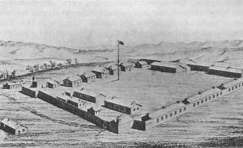 |
| Fort C. F. Smith in 1867. Sketch by Capt. I. D'Isay after Anton Schonborn's drawing. (National Archives) |
Indicative of the heat of the conflict was the Hayfield Fight. Early in the summer of 1867 the Sioux and Cheyennes agreed to a joint effort to wipe out Forts Phil Kearny and C. F. Smith, but a disagreement divided their formidable numbers into two factions, each to attack the fort of its choice. On August 1, 1867, one faction, made up of 500 to 1,000 Cheyennes and Sioux, fell upon a detail of a lieutenant, 19 soldiers, and six civilians working in a hayfield 2-1/2 miles from Fort C. F. Smith. Taking refuge in a log and brush corral, the intended victims withstood the attack all day long. When Lt. Sigismund Sternberg lost his life, one of the civilians, Al Colvin, who had been an officer during the Civil War, assumed command. The Indians, launching fierce assaults, suffered heavy casualties, but even fire arrows failed to dislodge the defenders. The Indians withdrew late in the afternoon, having killed three whites and wounded four. The next day, the other faction—Sioux led by Red Cloud—clashed with Fort Phil Kearny troops in the Wagon Box Fight.
When the garrisons of the three Bozeman Trail forts withdrew in 1868, in accordance with the Fort Laramie Treaty, the Indians burned all the posts. In time, the Indians in the Bighorn region were pacified and confined to reservations. As the gold fever subsided, ranchers moved into the area.
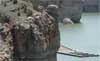
Bighorn Canyon National Recreation Area, established in 1966, is administered by the National Park Service through agreement with the Bureau of Reclamation. Mounds of earth tracing the foundations of the log and adobe buildings are all that remain of Fort C. F. Smith. A stone monument, erected by a local historical society, is located near the fort site, which is not impaired by any modern intrusions of consequence. Another stone marker stands at the nearby site of the Hayfield Fight. Wagon ruts from the Bozeman Trail, which forded the Bighorn River about 2 miles below the modern dam, are visible on both sides of the stream, especially the western side. A visitor center near the dam features historical displays and audiovisual programs showing construction of the dam.
 |
 |
http://www.cr.nps.gov/history/online_books/soldier-brave/sitea28.htm
Last Updated: 19-Aug-2005