


Survey of Historic Sites and Buildings
  |
FORT LARNED NATIONAL HISTORIC SITE Kansas |
 |
| ||
Located on the Santa Fe Trail in an area well known as an Indian rendezvous, Fort Larned was a major protector of the trail and one of the busiest posts in Kansas during the 1860's. It served as a base of operations against hostile tribes and was an Indian agency and annuity distribution point for those that were peaceful.
Settler and Army response to Indian depredations in Texas in the 1840's forced large numbers of Kiowas and Comanches to relocate farther north, especially along the Santa Fe Trail. Traffic on it boomed after the United States acquired the Southwest from Mexico in the mid-19th century. The gold rushes to California in 1849 and to the Pike's Peak region of Colorado in 1858 provided further stimulus. The Indians, angered by the invasion of their buffalo hunting grounds and the other disruptions, struck back with attacks on the trail. As a link between Forts Riley and Leavenworth, Kans., on the east, and Fort Union, N. Mex., on the west, in 1859 the Army founded a temporary post called Camp Alert, or Camp on the Pawnee Fork, near Lookout (now Jenkins) Hill about 5 miles from the Pawnee River's confluence with the Arkansas. The next year, at a site 3 miles to the west, the camp became a permanent installation, Fort Larned.
The new fort was the northern anchor of the line of forts defining the southwestern military frontier that extended south to the Rio Grande through Fort Cobb, Okla., and Forts Griffin, Concho, McKavett, Clark, and Duncan, Tex. One of Larned's prime responsibilities was defending the Kansas segment of the Santa Fe Trail, on which it was a way station, but it also cooperated with Fort Lyon, Colo., and Fort Union, N. Mex., in protecting the Cimarron Cutoff and the Mountain Branch. In 1864, when the Chivington Massacre fomented an Indian war on the Plains, at a time when most of the forts were not adequately manned because of the Civil War, the War Department prohibited travel beyond Fort Larned without armed escort. The fort furnished guard detachments for mail stages and wagon trains.
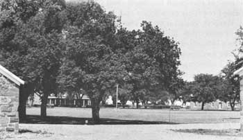 |
| View from southeastern corner of parade ground, Fort Larned NHS. Corner of old commissary building at left, north bachelor officers' quarters in left center, infantry barracks at right, and corner of new commissary building at extreme right. (National Park Service) |
Indians conducted numerous raids in the vicinity, and the fort fielded countless expeditions and patrols. In 1867 Gen. Winfield S. Hancock visited it on his abortive campaign against the southern Plains tribes. And it provided minor support to General Sheridan's 1868-69 campaign.
The fort was also an administrative center for the U.S. Government's unsuccessful attempts to pacify the Plains tribes by peaceful means. In the treaties of Fort Wise (1861), Little Arkansas (1865), and Medicine Lodge (1867), the Government agreed to pay annuities to the Cheyennes, Arapahos, Kiowas, Kiowa-Apaches, and Comanches in return for keeping the peace and not molesting the Santa Fe Trail. From 1861 to 1868, before the tribes were relocated to Indian Territory, Fort Larned served as an Indian agency.
Ironically, Fort Larned's last important function—protecting railroad construction crews—helped end the usefulness of the trail it had so long guarded. In the 1870-72 period the arrival of the Kansas Pacific and Santa Fe lines dealt a death blow to the trail. In the summer of 1878 the garrison moved to Fort Dodge, and 4 years later the Government sold the buildings and land at public auction. The Fort Larned Historical Society initiated a program in 1957 to preserve the fort and open it to the public. Seven years later it became a national historic site.
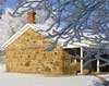
All the remaining buildings, nine in number, date from the period 1866-68, when the original sod and adobe buildings gave way to substantial limestone structures. They were later extensively modified for farm-ranch use. The National Park Service, carrying out a comprehensive historic preservation program, plans to restore these and reconstruct others. One of the two barracks, altered by raising the walls and adding a high connecting gambrel roof, now houses a visitor center, gift shop, and museum. Two of the three renovated officers' quarters are private residences. The third, part of which has been refurnished, is open to the public. The quartermaster storehouse and old commissary building, linked at present by a stone wall, contain exhibits relating to the fort and frontier history. A long shed joins the shop-bakery building, which once housed blacksmith, wheelwright, carpenter, painter, and saddler shops, as well as the post bakery, and the new commissary building. The National Park Service plans to rebuild the hexagonal blockhouse (1865). Santa Fe Trail ruts are visible in the vicinity of the fort.
NHL Designation: 12/19/60
 |
 |
http://www.cr.nps.gov/history/online_books/soldier-brave/sitea13.htm
Last Updated: 19-Aug-2005