|
ROCKY MOUNTAIN
The Geologic Story of the Rocky Mountain National Park Colorado |

|
THE PARK AS SEEN FROM THE TRAILS.
(continued)
WEST OF THE CONTINENTAL DIVIDE.
From Flattop Mountain "The Big Trail," as the Arapahoes called it, is near the crest of the range for some distance. The mountain top is strewn with bowlders, among which may be found in summer great numbers of brilliantly colored flowers. The trail across this bowlder-strewn surface is difficult to follow, but the difficulty has been lessened by the erection of monuments at short intervals. (See Pl. XXVIII, A.)
On descending to the west we enter a cirque at the head of one of the tributaries of North Inlet and follow a zigzag trail down the precipitous slope to its floor. Thence westward the floor of the glacial valley is traversed to Grand Lake—the "Holy Lake" or "Spirit Lake" of the Arapahoe Indians. The main glacier which shaped this valley originated in the several large cirques between McHenrys Peak, Mount Alice, and Andrews Peak and received numerous tributaries (see Pl. VIII, p. 30). These tributary glaciers were relatively weak and did not deepen their gorges as rapidly as the main glacier. Thus were formed hanging valleys like that in which Lake Nanita and Lake Nokoni are situated. One of the main tributaries from the north descended from Snowdrift Peak and formed the small hanging valley in which lies Bench Lake. The water from this lake descends about 700 feet to the main stream in a series of cascades. But the surrounding forest is so dense in this region that many an attractive scene is missed by the traveler who has no time for long detours from the main trail.
In fact, the trail through the whole length of the valley of North Inlet is so shut in by the forest that only an occasional and inadequate glimpse can be obtained of the gorge, which seems remarkably attractive and picturesque to one who can climb to some commanding point. The glacier left numerous proofs of its presence along the bottom and sides of this gorge. The trail drops from shelf to shelf of ice-polished rocks, and from these shelves the stream descends in rapids and falls (see Pl. XIII, A, p. 76), some of which are exceedingly picturesque.
The Grand Lake region has been described (p. 73), hence we shall return to Estes Park and enter the next trail to the south.
BARTHOLF PARK.
To reach Bartholf Park from Estes Park we follow up the Thompson River for nearly 4 miles, then cross it about a mile east of Moraine Park. Less than a mile from this crossing the route turns westward across the gently sloping surface of the parklike opening in which was established in 1910 the conference headquarters of the Young Men's Christian Association. Thence the road winds over a steep gravelly slope of disintegrated granite but before reaching the boundary line of the Rocky Mountain National Park passes on from this area of deeply weathered rock to the moraine of Bartholf Glacier.
Bartholf Park was called "Timbered Flat" by the Arapahoe Indians, and the western end of this flat was called "Where the Apache was Killed," or literally, "Where the Apache was Shot Off the Rock"; (sáy nénne-cheb tet, Apache Shot Off Rock). It is a basin-like opening among the mountains, timbered in some places, although many of the trees have been killed by fire since the name "Timbered Flat" was applied to it. It is the melting basin of the ancient Bartholf Glacier, and its origin is the same as that of Moraine Park and Horseshoe Park.
The moraines of this glacier are more complicated than those situated farther north. They consist of piles of bowlders of varying size and shape, and the surface is rough. The side of the lateral moraine just south of Bierstadt Lake is regular in form and is an excellent example of a morainal slope. But the terminal moraine and the numerous recessional ridges in the park form a rough, hummocky surface, with imperfect crescentic ridges, rock piles, small undrained lakes or pools, and poorly drained basins. The surface, as viewed from a commanding elevation, is one which may properly be described as tumultuous. The glacier seems to have worked with unusual intensity and left a great variety of land forms. Probably in no other part of the Rocky Mountain National Park can so many points of interest be found in so small an area. For unusual landscapes and for wild, fascinating grandeur the region surrounding this park is unsurpassed.
From Bartholf Park forks of the trail lead in several directions. One to the right leads to Bierstadt Lake in a zigzag course over the moraine, which here rises steeply 700 feet or more above the floor of the park. Another leads southward over Storm Pass to Longs Peak Inn. Near the western end of the park the trail forks again, the right prong leading to Bear Lake and the left into Loch Vale and Glacier Gorge.
BEAR LAKE.
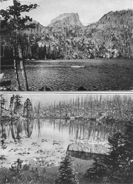
Bear Lake, with an area of 11 acres, is situated at an altitude of 9,542 feet. From the lodge on its shore excursions may be made to many parts of this most fascinating region. From this lodge we may look directly into the gorge between Hallett Peak and Flattop Mountain (Pl. XXXII, A). In this gorge lies Dream Lake, and on its steeply inclined floor are many recessional moraines or masses of bowlders dropped by the ice of the ancient glacier during the last stages of its retreat. At the head of the gorge lies Tyndall Glacier, the last remnant of the great body of ice which once filled it. At its lower end are large heaps of glacial material on which are situated such bodies of water as Bear Lake and its smaller neighbor, which some call Lilypad Lake (Pl. XXXII, B).
|
|
PLATE XXXII.
A (top). BEAR LAKE AND HALLETT PEAK.
Looking up the gorge between Hallett Peak (12,725
feet) and Flattop Mountain to Tyndall Glacier. The lake has an area of
11 acres and lies at an altitude of 9,542 feet The lake basin and the
rock-walled gorge between the two mountains are the work of an ancient
glacier which excavated this great hollow in the heart of the
mountains. B (bottom). LILYPAD LAKE, A DEPRESSION IN THE MORAINE NEAR BEAR LAKE. Most of the trees near the lake were killed by a forest fire which swept this region in the year 1900. The spectral remnant on the farther shore is all that is left of a once glorious forest of spruce and pine trees. Photographs by Willis T. Lee, United States Geological Survey. |
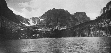
LOCH VALE.
The trail which was built into Loch Vale as far as The Loch (Pl. XXXIII) in 1916 winds in and out through a varied succession of cascades and bowlder-strewn gorges which lie between precipitous faces of rock. In many places the trees have been killed by fire and their dead trunks stand or lie among the remains of the dead glaciers. The weirdness of the landscape as it was left by the ice has been augmented by the destruction of the forest, and the specters created by the two opposing forces, heat and cold, here stand side by side. But there is some compensation even in destruction, for here many varieties of brilliant flowers bloom, especially the bright-red Indian paint brush and the still more brilliant fireweed.
|
|
PLATE XXXIII. LOCH VALE AS SEEN FROM THE LOCH.
To the left is the slope of Thatchtop Mountain and a part of Taylor
Glacier. In the center is Taylor Peak and the mountain spur that extends
from this peak northeastward between Loch Vale and Andrews Gorge. To the
right is the slope of Otis Peak, with Andrews Glacier in the distance. Photograph by Willis T. Lee, United States Geological Survey. |
Beyond The Loch we make our way with some difficulty through the brush and over the bowlders and up the rocky slopes to Taylor Glacier. The climber who is experienced in the exploration of glaciers may enjoy scaling this steeply inclined body of ice, but the inexperienced will do well to remain below. To the right, west of The Loch, is the great rocky gorge at the head of which Andrews Glacier is situated.
Loch Vale should be considered together with its neighbor, Glacier Gorge, but unfortunately neither is now easily accessible. The two constitute one of the most fascinating regions in the Rocky Mountain National Park, or in fact in mountain country anywhere.
LAKE MILLS.
Glacier Gorge can be viewed from above to much better advantage than from below, and its description is deferred (see p. 79). However, the hardy climber will doubtless feel amply repaid for his trouble of a thorough exploration as he gazes at the many unusual scenes in this remarkable gorge. Mills Lake, having an area of 10 acres, occupies a basin scooped out of the solid rock by the glacial ice that once filled this gorge.
The waterfall just below Mills Lake is one of the most picturesque to be found in the Rocky Mountains (see frontispiece). Its volume of water is not remarkably large nor is the height of the fall great, but the form assumed by the water as it pours over the rocks and leaps into spray or dashes among the bowlders and under the fallen trees is a picture not soon to be forgotten. Especially attractive is the view from below, where the forest is dense and dark and the gorge is narrow. The water seems to gush from the very mountain side, suddenly springing into brilliancy as it breaks over the rocks.
| <<< Previous | <<< Contents >>> | Next >>> |
sec3c.htm
Last Updated: 11-Dec-2006