|
ROCKY MOUNTAIN
The Geologic Story of the Rocky Mountain National Park Colorado |

|
THE PARK AS SEEN FROM THE TRAILS.
(continued)
MORAINE PARK.
Moraine Park is one of the favorite tourist resorts of the Rocky Mountain National Park. There are excellent geologic and physiographic reasons why this is so. Moraine Park and the history of its development would be a good subject for a dissertation upon physiographic influence on tourist travel. Many natural features of unusual interest, which are easily accessible from this park, result from the natural processes that are grouped under the general heading of physiography. The park itself was formed during the Great Ice Age by the glacier which crept down Forest Canyon bearing loads of bowlders, some of which it dropped at the sides to form the lateral moraines and some in the middle of the valley as ground moraine to build up the broad floor of the park.
On the route from Estes Park to Moraine Park we ascend Thompson River, leaving Gianttrack Mountain on the left. Near the mouth of Aspen Brook, just before reaching Moraine Park post office, we mount the terminal moraine of Thompson Glacier (see Pl. VIII, p. 30). This moraine shows to good advantage in the bed of the stream, where the swift current has carried away the finer material, leaving only the large bowlders, The town of Moraine Park is located on the top of this moraine. The even-floored valley called Moraine Park is the opening into which the ice from Forest Canyon pushed, spread out, and finally melted, depositing its load of débris to fill the valley, level its floor, and build the inclosing ridges. The essential features of this park and its relation to the high mountains are shown in Plate VII, B, p. 28.
The rocks over which the ice moved are striated and polished, but those outside the moraine are rough and irregular and the outer portions crumble easily. The difference in character may be readily distinguished from the road east of Moraine Park post office, where the road lies between the moraine, seen south of the stream and the unglaciated rock of the mountain side to the north.
A trail at the south side of Moraine Park leads up a tributary valley to Cub Lake. This valley is a short glacial gorge heading in a cirquelike depression in the side of the mountain. It receives very little drainage, and in these lakes, as in so many which contain nearly stagnant water, are great numbers of water lilies.
Near the west end of the park a trail branches off for Trail Ridge, which was used by the Ute Indians as a route across the Continental Divide. This is locally known as the Windy Gulch Trail. The Indians seem to have had the habit of choosing routes on which they could not easily be surprised by enemies. A steep, difficult climb out of Windy Gulch leads to the top of this ridge, which was described on page 54.
FERN LAKE AND ODESSA GORGE.
The road along the north side of Moraine Park is continued westward as the trail leading to Fern Lake. West of the park the valley narrows and assumes the U-shaped profile typical of a glacial gorge. Here the rocks are rounded and polished by the ice. Great bowlders of granite, some of them 40 feet or more in diameter, are strewn along the trail where they were dropped when the ice of the ancient glacier melted. Some of the bowlders may be seen perched high on the sides of the canyon. They appear to be so nicely balanced that they might be pushed from their pedestals with little effort. However, these balanced rocks have rested in their seemingly insecure position century after century, just as they were left by the ice which brought them from their native cliffs near the crest of the range.
The principal part of Forest Canyon is not now easily accessible from any direction, for trails have not yet been built into it. Near the point where Fern Creek joins the main stream the gorge is narrow, steep, and irregular in form. Where the trail crosses the stream the water races and plunges through a narrow gorge called The Pool. Its tumultuous action here is suggestive of the vastly greater and more profound disturbances in the ancestral glacier. What crevassing and grinding and crushing there must have been as the ice from Forest Canyon was joined by that from Spruce Canyon and from Odessa Gorge, and the combined mass forced its way through these precipitous, irregular narrows!
The trail follows Fern Creek, zigzagging up the steep side of the main valley to the hanging valley of Fern Creek, in the lower part of which Fern Lake is situated. Below this lake the stream leaps and dashes from bowlder and shelf in a series of rapids and cascades, descending 500 feet within a horizontal distance of about half a mile. The most accessible of the scenic features in this half mile are Marguerite Falls and Fern Falls. At the latter the water has nearly a sheer drop and forms a typical waterfall. These falls and rapids are rendered particularly attractive by their wild surroundings of mossy crags and evergreen trees.
Fern Lake (Pl. XXV) occupies a typical glacial basin. It is surrounded on all sides by steep forested mountain slopes, on which ice-smoothed surfaces of rock may be seen in many places. Odessa Lake occupies a similar depression about 500 feet higher. The view up Odessa Gorge (Pl. XXIV, A) is particularly attractive. Flattop Mountain (12,304 feet) appears at the left of the gorge, and Notch Mountain, as it is called locally, to the right. Above Odessa Lake we work our way over the steeply inclined floor of the gorge, meeting with scenes of rare beauty at every turn. From the great bank of snow near the top the water gathers in a minute lake from which it pours over the rim of the cirque at Grace Falls. In its passage down the gorge numerous little lakes and cascades are formed. In some places the water disappears from sight under loose aggregates of bowlders. In other places it is hidden beneath great banks of snow which fill the gorge from wall to wall and from which it emerges as if from the mouth of a cave.
|
|
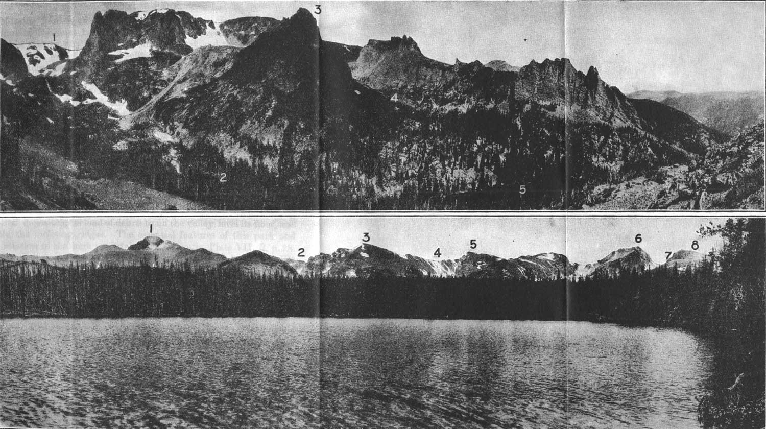
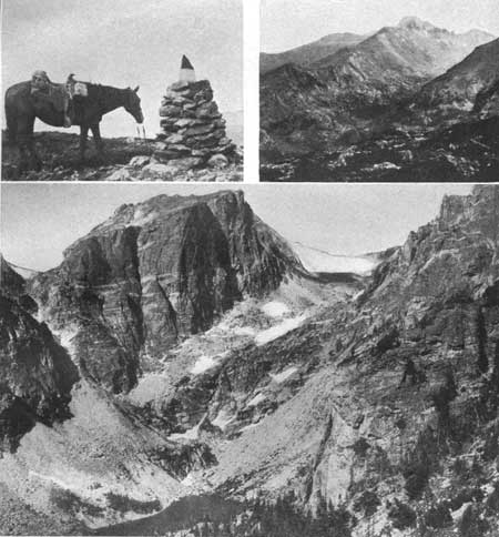
PLATE XXIV.
A (top). ODESSSA GORGE AS SEEN FROM THE MOUNTAIN SOUTH OF ODESSA LAKE.
1, Flattop Mountain; 2, Odessa Gorge; 3, The "Matterhorn"; 4, gorge of
Tourmaline Lake; 4, Odessa Lake. B (bottom). CREST OF THE SNOWY RANGE FROM LONGS PEAK TO FLATTOP MOUNTAIN, AS SEEN FROM BIERSTADT LAKE. 1, Longs Peak; 2, Glacier Gorge, 3, Thatchtop; 4, Loch Vale; 5, Taylor Peak; 6, Hallett Peak; 7, Tyndall Glacier; 8, Flattop Mountain. Photographs by Frank W. Byerly. VIEWS IN THE ROCKY MOUNTAIN NATIONAL PARK. (click on image for an enlargement in a new window) |
|
|
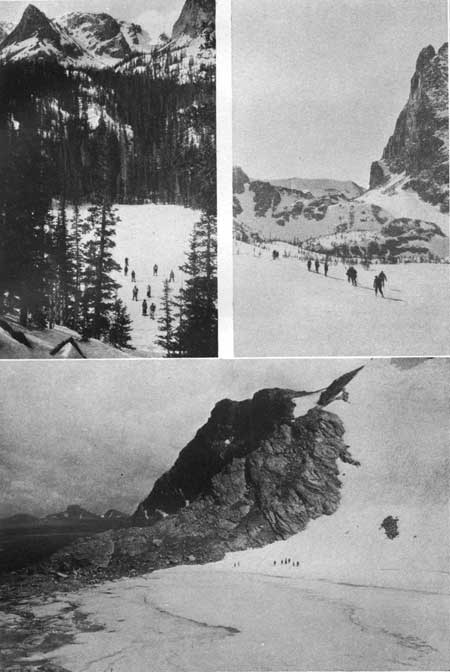
PLATE XXV.
WINTER SPORTS IN THE HIGH MOUNTAINS. Upper left, Fern Lake frozen over and covered with snow. Odessa Gorge and Flattop Mountain in the distance. Photograph by Frank W. Byerly. Upper right, Snowshoeing on the Continental Divide. Notchtop on the right. Photograph by John K. Sherman. Lower, A part of Sprague Glacier. In the distance at the left is the square head of Longs Peak, which seems to rise abruptly from the high-altitude plain that lies between Sprague Glacier and Longs Peak. Photograph by Frank W. Byerly. |
To the right, or north of the gorge, stands Notch Mountain, a projecting angle of Flattop Mountain, with sides rising almost vertically to the gently undulating surface at the top. Farther to the right is a little tributary cirque across the mouth of which is a mass of rock fragments piled up by the ice which once filled this cirque. This mass was built out so near the edge of the cliff that some of it has slipped off as a landslide (see Pl. XXIV, A). A little farther to the right a similar cirque, but one more perfectly formed, is occupied by Tourmaline Lake. This is one of the objective points for sightseers and is usually reached from Fern Lodge.
A superb view of wild, inaccessible mountain slopes may be obtained toward the northwest from Fern Lake. The point south of Spruce Canyon stands out as a wonderfully conspicuous sharp-pointed crag, and Stones Peak (12,928 feet) seems to push its precipitous snow-flecked cliffs into the very clouds.
Although the Rocky Mountain National Park is used principally as a summer playground, there are some who maintain that it is no less attractive in winter. Fern Lake and other parts have been visited in winter by those who delight in snowshoeing and skiing when the lakes are frozen and the bowlders buried and the evergreens draped in their mantles of white.
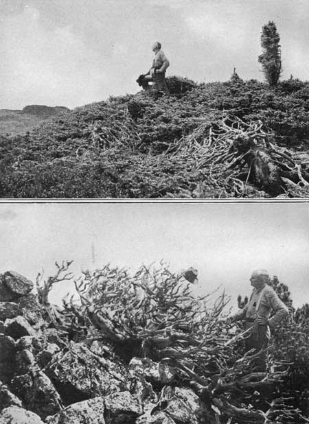
The remarkable timber-line trees conspicuous in the Longs Peak region, where they are particularly well developed, are by no means confined to that region. Many interesting specimens of them are found in Odessa Gorge. They are curiously stunted and gnarled. They exist under most adverse conditions and grow very slowly. It has been said by those who have studied these trees that on the average it takes a century to grow a branch 1 inch in diameter. The tree in the accompanying illustration (Pl. XXVI, B) has a trunk nearly 3 feet in diameter, although it is only about 2 feet high. At the above rate of growth this tree is more than 3,000 years old. During that time it succeeded in sending branches to a height of about 5 feet. The branches of these trees are tough, wiry, and unyielding. They form a tangled, interlacing mass so strong that one can walk over them but can not push through them (Pl. XXVI, A). The closely woven branches catch the drifting snows of winter and make of them a protecting cloak.
|
|
PLATE XXVI.
A (top). A FOREST OF PINE TREES
A group of trees forming a mass of interlocking
branches so dense and unyielding that one can walk on them but not
though them. The tangle of branches is shown by the dead tree in the
foreground, which, though little more than 2 feet high, has a trunk
about 1 foot in diameter. B (bottom). A LIMBER PINE. This tree grew in a spot sheltered by rocks from the strong westerly winds. It is about 5 feet high and has a trunk about 3 feet in diameter, These trees are said to grow at the rate of 1 inch in a century, hence this tree is more than 3,000 years old. TIMBER-LINE TREES IN ODESSA GORGE. Photographs by Willis T. Lee, United States Geological Survey. |
SPRAGUE GLACIER.
By a side trip from Fern Lake we may reach Sprague Glacier, a large mass of ice supposed to be a remnant of one of the great glaciers of long ago. According to information received from Enos A. Mills (p. 30) a test extending over 15 days was made on Sprague Glacier in 1906, when it was found that the ice was moving at the rate of eight-hundredths of an inch a day. This rate of movement would carry the ice 2 feet 5 inches in a year, a rate of movement which seems to place this body of ice appropriately in the class of true glaciers.
The high-altitude peneplain or gently undulating surface at the top of the range called the Flattop peneplain, because of its typical development on Flattop Mountain, is well shown here, and its relation to the more recent erosion is beautifully illustrated. In the illustration (Pl. IX, p. 34) the relatively smooth surface shown at the top is a remnant of the once continuous surface formed by erosion, probably at a much lower altitude. Later the mountains were uplifted (see p. 21) and the gorges were cut in the elevated mass by rain and ice. In some places the old surface was entirely destroyed, but here the relation of the old and the new surfaces is shown conspicuously where the snow which drifted from the old plain on Flattop has lodged in the lee of the mountain on the walls of the newly formed gorge at the head of Spruce Canyon (see Pl. IX, p. 34).
FLATTOP TRAIL.
Under this general heading may be described several of the scenic features in easy reach from the trail between Estes Park and Grand Lake, such as Bierstadt Lake, Tyndall and Andrews glaciers, and Hallett Peak. The Flattop Trail is the southernmost of the two routes across the range, the northern one being by way of Fall River Canyon. In order to reach Flattop from Estes Park we leave Thompson Canyon east of Moraine Park and ascend Milk Creek. For about a mile this creek flows in a trough between the morainal ridge south of this park and the northern slope of the moraine of Bartholf Glacier. This creek marks the line of nearest approach of the two ancient glaciers and probably at the time of their maximum extension they actually joined.
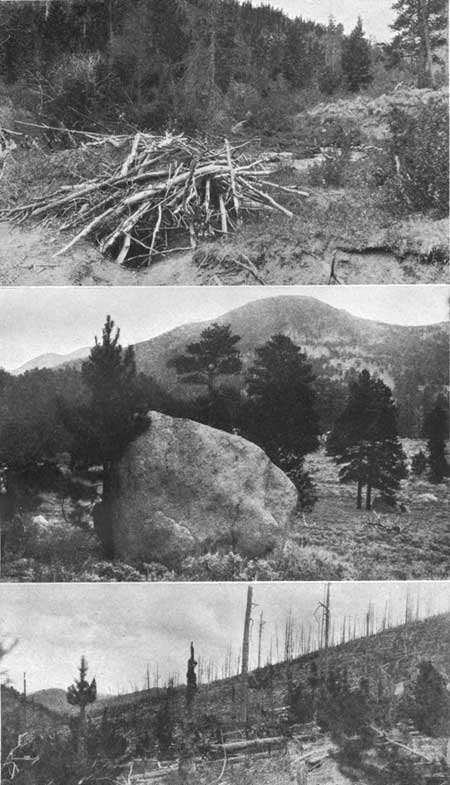
West of the trough we enter a small triangular parklike opening shut in on all sides by steep slopes. To the north rises the moraine of Thompson Glacier, to the southeast the moraine of Bartholf Glacier, and to the west the unglaciated slope of the mountain which separated these glaciers. In this triangular opening, as in almost every other place in these mountains where opportunity is given, beavers have established themselves. Occasionally a dam is broken and a beaver lodge destroyed, as here (Pl. XXVII), where the mud which once covered the framework of the dwelling crumbled when the pond in which it was built was drained.
|
|
PLATE XXVII. SCENES ON MILK CREEK. Upper, A ruined beaver lodge on Milk Creek, deserted when the pond in which it was built was drained. The "front door" is seen at the bottom. Middle, A typical scene in the area formerly occupied by the glaciers. This bowlder of granite was shaped by Thompson Glacier, carried by the ice many miles from its parent mountain, and deposited on this nearly level surface when the ice melted away. Lower, The "ghost" of a forest where the timber was destroyed by fire. Photographs by Willis T. Lee, United States Geological Survey. |
West of this opening, as we follow up Milk Creek, we enter another trough, the northern wall of which is formed by the unglaciated rock and the southern wall mainly by glacial débris. For a considerable distance west of Ranger Station Milk Creek marks the junction of the moraine with the solid rock. South of Ranger Station the trail zigzags up the face of the moraine, where it forks, one prong leading to Bierstadt Lake, another to Bear Lake, and a third to Flattop Mountain. By a short side trip Bierstadt Lake is reached.
BIERSTADT LAKE.
Bierstadt Lake lies on the very top of the great glacial moraine which was built up at the side and end of Bartholf Glacier. Because of this perched condition the Indians called it Hanging Lake. The moraine is densely forested in the vicinity of the lake, but the trees have been killed by fire in neighboring parts. A magnificent view of the high mountains may be obtained from the shore of this lake (Pl. XXIV, B).
The lake is named for the artist Albert Bierstadt, a landscape painter of international fame, who came to Estes Park in 1874 as a guest of the Earl of Dunraven. The beauty of the scenery in the vicinity of the park attracted the artist, and the sketches for one of his famous paintings were made here.
FLATTOP MOUNTAIN.
West of Bierstadt Lake the trail winds at first through a dense forest and later crosses an area where the trees were killed by fire in 1900.1 Many of the trunks are standing, others have fallen, making almost impenetrable thickets. Near the edge of this spectral reminder of a once noble forest we leave the moraine and enter an area of rough, unglaciated rock. Here the slope steepens and is covered with angular bowlders. Above timber line these bowlders are numerous, and the mountain slope is so steep that little soil remains on it. This want of fine material renders trail making difficult, and the path winds among the rocks wherever an opening can be found.
1The date of a forest fire may be determined by counting the annual rings of growth of trees which sprang up in the fire-swept zone. Enos A. Mills, who has made a special study of trees in the vicinity of Estes Park, gives the following information in a communication to the writer:
"Previous to 1781 Estes Park and other open places in the mountains, like Middle Park, west of the range, were covered with forests of Douglas pine. These were devastated by fire in this year. This fire, which swept the Grand Lake region, middle St. Vrain, Wild Basin, and neighboring regions, seems to have been general on both sides of the range.
"In 1864 the east side of the range was swept by fire. The destruction was especially heavy east of Longs Peak. The trunks of trees killed by this fire are still standing in many places on the side of Twin sisters.
"In 1878 fire again swept Wild Basin.
"In 1886 fire swept for a second time over parts of the territory east of Longs Peak, especially over the lower part of Mills Moraine and the south slope of Twin Sisters.
"In 1900 a small area on Mills Moraine was burned over. In the same year a separate fire burned over Glacier Gorge, Loch Vale, and parts of Bartholf Moraine near Bierstadt Lake."
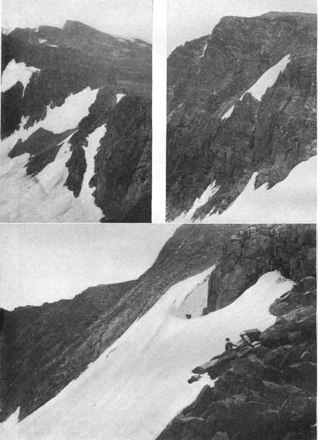
It would be difficult to follow a dimly marked or snow-covered trail through this monotonous wilderness of bowlders. In order to safeguard the traveler against accidents during storms, the part of this trail above timber line has been marked by conspicuous monuments (Pl. XXVIII) set at short intervals. By means of these a storm-confused traveler may find his way down the slope on either side of the divide to timber, where the trail is more easily followed.
|
|
PLATE XXVIII. SCENES ON FLATTOP TRAIL. Upper left, One of the monuments on the trail of Flattop Mountain. Upper right, Longs Peak and Glacier Gorge as seen from the trail on Flattop Mountain. Longs Peak was named for Maj. S. H. Long and is the loftiest summit of the Front Range in northern Colorado. Lower, One of the spectacular scenes in the Rocky Mountain National Park, due to glacial action—Hallett Peak, Tyndall Glacier, and the upper part of the gorge formerly occupied by glacial ice, as seen from the point where the Flattop trail approaches the rim of the gorge above Dream Lake. The remnant on the right is the side of Flattop Mountain. The gorge is the handiwork of the ancient glacier which gnawed into the heart of this originally rounded summit. Photographs by Willis T. Lee, United States Geological Survey. |
For a considerable distance up the east slope the trail is close to the edge of the precipitous cliff which forms the north wall of the gorge below Tyndall Glacier. At one point the trail is on the extreme edge, and we look downward 1,000 feet to Dream Lake (Pl. XXVIII) and outward into the remarkable gorge which was once occupied by the ancestor of Tyndall Glacier. At that time this glacier was a masterful body of ice instead of the feeble, dying, or perhaps wholly lifeless remnant of ice that it is at the present time.
Here the trail leaves the gorge and winds up the eastern slope of the ridge to the broad, gently sloping surface at the top, which, in comparison with the cliffs and precipitous slopes on either side of it, seems flat and is appropriately designated the flat top. The particular part of this slope called Flattop Mountain is only a small part of the gently undulating surface, remnants of which are found at the top of the highest mountains throughout the park along the Continental Divide. The water falling as rain west of this divide drains westward and enters the streams near the head of Grand River, finding its way at last to the Pacific Ocean. The rain falling east of this divide finds its way down the Big Thompson and out over the Great Plains to the Mississippi Valley and finally to the Atlantic. Hence the Continental Divide is the line of separation between the Atlantic and the Pacific drainage. It is here that the waters start on their long journey, hence their powers of erosion here are slight. For this reason the surface of Flattop has been preserved, while the old plain elsewhere has been entirely destroyed.
However, it is quite otherwise with the precipitation which comes in the form of snow. The prevailing westerly winds of winter sweep with such force over the unprotected surface of the high plain that large quantities of snow drift over the crest and accumulate in the deep cirques below the rim (Pl. XXIX). In this way the glaciers are formed. Were it not for this drifting of snow from the high plain and the protection afforded by the steep-walled cirques, it is doubtful if there would be any glacier in the Rocky Mountain National Park, although Hallett Glacier seems to be an exception.
|
|
PLATE XXIX. ON THE CONTINENTAL DIVIDE. Upper left, How a glacier is fed. A part of Flattop Mountain and the rim of the precipice at the head of Tyndall Glacier. In winter the snow is swept by the wind from the gently sloping surface at the top and is deposited in the lee of the cliffs. Upper right, A hanging glacier, a mass of snow and ice anchored to the solid rock in a sheltered nook of the precipice south of Hallett Peak. Masses of ice in such situations, if large enough, scoop out the tributary cirques and form the basins in which the pocket lakes are found. Lower, The upper end of one arm of Tyndall Glacier. The semicircular hollow is formed by the melting of the ice, due to radiation of the sun's heat from the rocks. Photographs by Willis T. Lee, United States Geological Survey. |
It takes time to convert these accumulations of snow into glacial ice, and during this time the whole mass is slowly creeping down the slope. The upper part, called névé, is only partly transformed to ice and does not move as readily as the true glacial ice below. Hence the lower part of the mass settles away from the upper part, or névé, forming an open fissure, called the Bergschrund (see Pl. XXX).
|
|
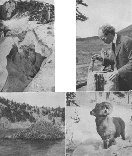
PLATE XXX.
Upper left, A bergschrund on Tyndall Glacier, where the freely moving
glacial ice below pulls away from the névé above. Photograph by
George H. Harvey, Jr. Upper right, Enos A. Mills and one of his pets at Longs Peak Inn. Great numbers of these tamed chipmunks live at the inn and are sources of amusement to the guests. Lower left, A beaver lodge. Beavers are numerous in the park, and their lodges in ponds may be seen in many places. Photograph by Enos A. Mills. Lower right. A bighorn sheep. The mountain sheep are numerous in the northern park. Photograph by Enos A. Mills. |
The present glaciers furnish the key for unlocking some of the mysteries of the older and larger glaciers; the processes by which the present masses of ice are formed are probably identical with those which operated in the past. Doubtless, then as now, the winter winds were prevailingly from the west, and great quantities of snow drifted from the high plain and accumulated in such valleys as existed at that time. When these accumulations became voluminous enough, they began to move down the valleys, after the manner of glaciers, and by continued movement through long ages they scooped out the gorges and cirques. The snow which fell too far west of the divide to be swept over the crest accumulated at the head of the westward-sloping valleys and formed the glaciers of the western slope. But it is probable that the high plain at the top of the mountains remained relatively free from ice throughout the Great Ice Age, hence it escaped the intense gouging which the areas on either side experienced.
Throughout the park large bodies of snow and ice, which never entirely melt away, have accumulated near the heads of the gorges. This is particularly noticeable between Flattop and Longs Peak. Most of them seem to be motionless and are the dead remnants of glaciers that once were active, but a few have recognizable motion and may therefore be called true glaciers. Others are so small and their motion so slight that there is doubt about their glacial character (see p. 30).
GLACIERS AND GORGES SOUTH OF FLATTOP.
The crest of the range south of Flattop Mountain is most conveniently reached from the Flattop Trail. Hallett Peak, a rounded dome sheared at the side and rising somewhat abruptly from the Flattop peneplain (Pl. IX, p. 34), is one of the chief objects of interest in this region. It overlooks some of the wildest landscapes in the national park, and the Arapahoe Indians called it "Thunder Peak" (bonnahah-nottayah), from the thunder clouds which often hung over its summit.
The gorge south of this peak presents many unique features. Its snow fields, or glaciers, if they are such, have not yet been dignified with names. One of these especially deserves mention (Pl. XXIX, upper right), for it is a beautiful illustration of a hanging glacier, nestled in a hollow of the cliff and anchored by its ice roots to the solid rock.
At the head of the gorge south of Otis Peak lies Andrews Glacier. It is one of the largest masses of ice in the park and fills the upper part of its gorge, extending from the rim down to the lake which washes the lower end of the ice. Beneath the surface of this lake the hard blue or true glacier ice projects beyond the softer ice above it, which is more rapidly melted by the water. The surface of this glacier has a beautiful convex form (Pl. XXXI), probably because of radiation of the sun's heat from the rocks at the side. The middle of the ice, at a greater distance from the sun-heated cliff, is melted less rapidly than that at the sides.
|
|
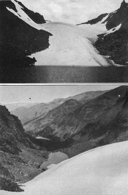
PLATE XXXXI.
A (top). THE GLACIER AS SEEN FROM THE LAKE AT THE FOOT OF THE ICE.
This is one of the finest beds of eternal snow and ice in the Rocky
Mountain National Park. B (bottom). THE EDGE OF THE GLACIER AS SEEN FROM ABOVE, LOOKING EASTWARD DOWN THE GORGE. ANDREWS GLACIER. Photographs by Willis T. Lee, United States Geological Survey. |
Taylor Glacier, situated at the head of Loch Vale, is a long, steep body of ice clinging to the precipitous face of the cliff, anchored, doubtless, in crevices and reentrant angles in the rock. It is difficult of access from above and is more often approached from Loch Vale, although for want of suitable trails this is no easy matter.
In each of the several gorges is a succession of small lakes, most of which occupy basins cut in the solid rock. These lake basins were gouged out during the time of expansion of the ancient glaciers by bowlders held frozen into the ice. Each fragment thus dragged downward by the glacier helped to scour out the hollows and smooth the rocks over which they moved. However, a few of the lakes occupy depressions in morainal material or are formed behind dams built of glacial bowlders and rock meal.
One of the most beautiful of the gorges of this region is Loch Vale, which may be viewed either from above on the high ridge west of Andrews Glacier or from below. At its head is a typical glacial cirque, opening downward through a beautifully formed glacial gorge, the floor of which descends from shelf to shelf like a giant stairway. A small lake has formed on each shelf, as if the glacial giant strode down this stairway, leaving a hollow footprint at each step in which the water gathered to form a lake.
| <<< Previous | <<< Contents >>> | Next >>> |
sec3b.htm
Last Updated: 11-Dec-2006