|
ROCKY MOUNTAIN
The Geologic Story of the Rocky Mountain National Park Colorado |

|
THE PARK AS SEEN FROM THE TRAILS.
(continued)
ESTES PARK TO LONGS PEAK.
ROUTES.
Three routes are available between Estes Park and Longs Peak. One passes east of Prospect Mountain through the Dunraven property1 and up Fish Creek, Another follows up Thompson River for about 2 miles, where it turns to the left and joins the first route. The third is by way of Aspen Brook.
1in his "Story of Estes Park" (p. 43, 1914), Enos A. Mills says:
In the autumn and early winter of 1872 Earl Dunraven, with his guests, Sir William Cummings and Earl Fitzpatrick, shot big game in the park. Dunraven was so delighted with the abundance of game and the beauty and grandeur of the scenes that he determined to have Estes Park as a game preserve. * * * In 1874 Albert Bierstadt, the celebrated artist, came in as the guest of Dunraven and at once selected sites for Dunraven's cottage and the Estes Park Hotel. Bierstadt was delighted with Estes Park and made the second trip to it. Here he made many sketches and secured material for some of his famous pictures. His favorite place was on the shore of the lake which now bears his name."
On the second or main route we pass Marys Lake, a small body of water beautifully situated in the midst of a smooth rolling greensward and surrounded by granite crags which stand like monuments in a park. From points south of this lake superb views may be obtained of Estes Park and of the mountains surrounding it.
After a steep rise at the head of Fish Creek valley we reach Lily Lake, which is situated practically on the divide between Aspen Brook and the head of Fish Creek. Just north of this lake is Lily Mountain (9,793 feet), the top of which forms the picturesque serrate crest seen from points farther west. Thence southward we pass into the broad open trough near the head of Cow Creek, called Tahosa Valley, a name appropriately expressing its situation, for it is said to mean "Dwellers in the mountain tops." The Arapahoes called the pass at the head of this valley "here the Woman was Killed": Issay-bes—di—noh-kah wah—náytowah ali—náyt (Woman Log-It-Killed-Her). This name refers to the death of an Indian squaw who was killed there by a falling tree.
LONGS PEAK INN.
Longs Peak Inn holds the same relation to the southern part of the Rocky Mountain National Park that Estes Park village holds to the northern part; for it is the center from which trails radiate to points of interest. The site of this inn was first occupied by E. J. Lamb in 1875. Mr. Lamb lived here for many years and established himself as a guide to Longs Peak.
From the inn several panoramas open to view, which make this a favorite resort. The gentler slopes of the surrounding mountains are beautifully decorated with the dark-colored evergreens, prominent among which is the lodge pole pine, and with the lighter green of the aspens. Here and there are areas covered with trunks of trees which were killed by forest fire. Some of those on the mountain slope west of the inn were killed in the year 1864 (see p. 63).
TWIN SISTERS.
To the east of Longs Peak Inn stands the precipitous craggy mountain called Twin Sisters (11,384 feet), Because of a well-built trail the climb up this mountain is relatively easy. From many points on the trail superb views may be obtained, but the dominating one is that which opens from the summit. Here the entire sweep of the compass is at our command. The trail zigzags up the steep slope, at first through the evergreen forest and finally through the lifeless trunks of trees killed by the forest fire of 1864. Near the top of the mountain are many of the curious gnarled, stunted, and wind-twisted trees usually found near timber line.
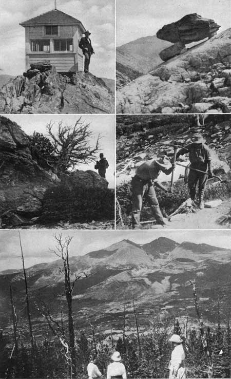
The top of this mountain is used by the Forest Service as an observing station. From the observatory on the summit (Pl. XXXIV), which commands a view of a large part of the national park and much of the neighboring national forest, a fire may be located accurately and its position reported by telephone. From this commanding point we may gaze eastward far out over the 25-mile belt of lower mountains to the plains beyond. East of the foothills, at distances of 30 to 35 miles, lie clearly outlined the irrigated lands and the numerous reservoirs where irrigation water is stored. Still farther to the east, as far as the eye can reach, stretches the apparently even surface of the Great Plains. To the north and to the south lie mountainous areas which from this commanding elevation resemble the billowy surface of a storm-tossed sea; but the crowning glory is the view to the west across Tahosa Valley to Longs Peak (Pl. XXXIV, lower) and its neighboring mountains.
|
|
PLATE XXXIV. SCENES NEAR LONGS PEAK
INN. Upper left, Fire observer's station on the top of Twin Sisters. From the summit of this lofty mountain the view is unobstructed for many miles in all directions. The peak is used by the Forest Service for discovering and locating forest fires. The observatory is bolted to the rocks to keep it from blowing away. In it are instruments and maps by means of which a fire can be accurately located and the information telephoned to the rangers whose business it is to extinguish the blaze. The fire observer lives in a stone cabin built in a sheltered nook in the side of the mountain just below the observing station. Photograph by E. P. Cole. Upper right, A balanced rock left on an ice-smoothed surface when the glacial ice melted from The Chasm on Longs Peak. Middle left, Timber-line trees on Twin Sisters. The dark-colored mass in the foreground is a living pine tree about 3 feet high. The dead tree, about 5 feet high, has a trunk nearly 2 feet in diameter and is probably about 2,000 years old. Middle right, The trail makers at timber line on Longs Peak. Lower, Longs Peak from Cabin Rock. In the foreground is the broad Tahosa Valley, in which Longs Peak Inn is situated. Showing also Longs Peak, Mount Meeker, Mount Lady Washington, The Chasm in the face of the mountains, and the heap of fragmental rock nearly 1,000 feet high carried by Mills Glacier out of The Chasm and deposited in the moraine. Photographs by Willis T. Lee, United States Geological Survey. |
Northwest of the inn stands Estes Cone (11,017 feet), one of the isolated remnants of erosion which are so prominent in the vicinity of Estes Park. By way of the trail over Storm Pass west of this cone tourists from the inn may reach Bartholf Park and the picturesque region of Glacier Gorge and Loch Vale. Farther south is Battle Mountain and the Longs Peak trail.
But probably the most interesting of all the features to be seen from this commanding point are those in the eastern face of Longs Peak. From Twin Sisters we gaze directly into the great cirque known as The Chasm, shut in by the almost perpendicular faces of Longs Peak, Mount Meeker, and Mount Lady Washington. The western wall of this cirque constitutes the smooth, nearly vertical face of Longs Peak, which rises 2,400 feet above Chasm Lake, while the northern and southern faces are scarcely less precipitous but are more ragged and irregular.
The impression obtained on viewing this group from below, that there are three distinct mountains, is chiefly due to perspective. Mount Lady Washington (13,269 feet) is only about 300 feet higher than the lowest part of the ridge connecting it with the master peak. Mount Meeker (13,911 feet) is a little more distinct, its peak rising about 500 feet above the lowest part of the ridge that connects it with Longs Peak (14,255 feet). Meeker and Lady Washington are closer to the observer than Longs Peak and therefore when viewed from below appear nearly as high.
These three peaks form a single mountain mass. Before the Great Ice Age they were even more closely connected than they are now—probably so closely that they formed a single rounded summit. When the ice began to form during the glacial epoch it naturally accumulated around this highest mountain of the region. One glacier found its way down Hunters Creek toward the south and east into the valley of the North St. Vrain. Another moved toward the west and north through Glacier Gorge. Still another moved northward across Boulder Field and down into Bartholf Park. A fourth but relatively small one, known as Mills Glacier, formed on the eastern face of the mountain. It was this glacier that left records which appear so conspicuous from the top of Twin Sisters. In its early stage it spread out rather broadly and extended eastward beyond the road south of Longs Peak Inn.
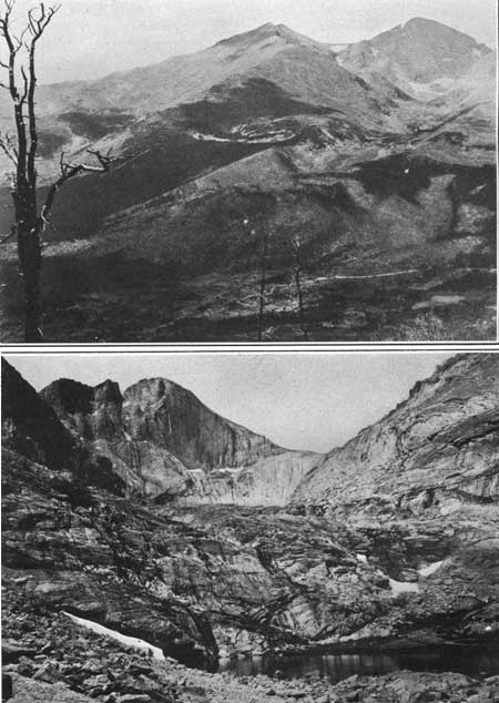
Later this glacier, in a less extended form, built up the conspicuous ridges called Mills Moraine. The rocks plucked from the side of the mountain during the excavation of The Chasm were carried out by the ice and deposited in two parallel ridges or lateral moraines, the one north and the other south of Roaring Fork. This creek now occupies the trough down which the ice moved. The photograph (Pl. XXXV, A) of the cirque and moraine taken from Twin Sisters gives a better conception of the relation of this glacier to the peak than can be given in words.
|
|
PLATE XXXV.
A (top). MILLS MORAINE AND THE CHASM ON LONGS PEAK.
The moraine—the crescent-shaped ridge in the middle ground—is
composed of rock fragments carried by the ancient glacier from The Chasm
and deposited at the sides and end of the ice. The moraine is about 2
miles long and its two ridges are half a mile apart. B (bottom). NEAR VIEW OF THE CHASM. Looking up the gorge toward Longs Peak from the lake half a mile east of Chasm Lake. The floor and walls are composed of barren rock just as they were left when the ice of Mills Glacier melted. Photographs by Willis T. Lee, United States Geological Survey. |
LONGS PEAK TRAIL.
Longs Peak is the culminating point of the park and has long been one of the best-known summits in the Rocky Mountains. A number of historical notes concerning it have been collected by Enos A. Mills in his work entitled "The story of Estes Park," and from this account have been extracted the following notes:
In November, 1806, Longs Peak was seen from the plains by Lieut. Pike, who called it Great Peak.
On July 3, 1819, members of Col. S. H. Long's exploring party, while camped at the mouth of the Cache la Poudre, named Great Peak in honor of their leader. Since that time it has been known as Longs Peak. However, Long was never on this mountain.
In August, 1864, the first attempt seems to have been made to climb Longs Peak. W. N. Byers, with three companions, scaled Mount Meeker and went some distance through the Keyhole on the present trail of Longs. The attempt was unsuccessful, and on the 20th of August, 1864, Mr. Byers wrote:
We have been almost all around the peak and we are quite sure that no living creature, unless it had wings to fly, was ever upon its summit. We believe we run no risk in predicting that no man will ever be, although it is barely possible that the ascent can be made.
Four years later the intrepid Mr. Byers broke his own prediction by leading a party of climbers to the top.
On August 23, 1868, the first ascent of Longs Peak was made. The persons who made it were Maj. J. W. Powell, W. H. Powell, L. W. Keplinger, Samuel Gorman, Ned E. Ferrell, John C. Sumner, and William N. Byers.
In making this ascent the climbers started from Grand Lake, crossed the Continental Divide into Wild Basin, and ascended the southern slope, passing near the Notch and over the Home Stretch (Pl. XLII, p. 80).
In August, 1871, Rev. E. J. Lamb, the first regular guide on Longs Peak, made his first ascent, and in coming down descended the "east precipice," a feat but once repeated—by Enos A. Mills in June, 1903.
In September, 1871, Dr. F. V. Hayden, of the Geological and Geographical Survey of the Territories, visited the park, and climbed Longs Peak. In his party was Anna E. Dickinson, who is supposed to be the first woman to make this ascent. Her name is perpetuated in Mount Dickinson. This party gave the names Mount Meeker and Mount Lady Washington to the companions of Longs Peak.
In ascending Longs Peak we start from Longs Peak Inn and follow the trail westward through the forest of pine, spruce, and aspen. On the trail is an abandoned prospect, locally known as "the mine," near which the surface is covered with fragments of milky quartz derived from a large vein, into which an entry was once driven in search of gold.
Soon after passing this old mine we leave the rocky slope and ascend the outer rim of the lateral moraine of Mills Glacier. To the left, just south of Alpine Brook, rises the steep slope of the inner or younger moraine of this glacier. This is built of ice-borne material dropped along the northern margin of the great tongue of ice which once extended from The Chasm down the mountain side for about 4 miles, The maximum depth of this great mass of bowlders seems to be nearly 1,000 feet.
After traversing the outer moraine for a short distance we find ourselves again on the unglaciated rock outside of the moraine. Alpine Brook occupies the trough between the moraine and the solid mountain rock. Near timber line a log cabin has been constructed on the slope of Battle Mountain, a few rods from the outer edge of Mills Moraine, for the accommodation of visitors to the numerous points of interest near Longs Peak. The cabin is at an altitude of about 11,100 feet, and a few minutes' walk from it brings us to a large bank of perpetual snow and to an unusually fine group of the curious gnarled and dwarfed pine and spruce trees which grow at timber line. From this cabin we obtain an excellent view of the moraine to the south. The trees between it and the moraine are only a few feet high and do not interfere with the view. That part of the moraine lying above timber line is barren, and much of that below was laid bare in 1900 by a forest fire which swept this part of the mountain side.
POINTS OF INTEREST NEAR TIMBER LINE.
Several localities of unusual interest may be visited by short excursions from Timberline Cabin, among which may be mentioned Mills Moraine and the glacial trough lying between the two morainal ridges, The Chasm, and the grove of timber-line trees near Longs Peak trail.
Mills Moraine.—By a short and relatively easy walk directly south from the cabin we reach the crest of the moraine and from some vantage point on it we gaze into the great trough, hundreds of feet deep and nearly half a mile wide, which was once filled with ice. Its sides are precipitous and show bowlders of varying shape and size, piled in haphazard manner. In some places these are so nicely balanced that caution is necessary in climbing over them, for the pressure of the foot is sometimes sufficient to start a bowlder crashing down the steep slope. It is interesting to note that where the material beneath the original surface has recently been uncovered, the spaces between the bowlders are filled with smaller fragments and with rock meal ground fine by the moving ice. The bottom of the trough consists of heaps of bowlders irregularly placed and forming imperfectly constructed crescent ridges, convex downstream, which were formed during the halting recession of the glacier. On the upstream sides of some of these ridges water has gathered in small lakes along the course of Roaring Fork, a name quite appropriate for a stream which falls 2,500 feet in the course of less than 2-1/2 miles and which finds its way though such a wilderness of bowlders as that left by Mills Glacier.
The Chasm.—The Chasm is a great rock-walled cirque in the eastern slope of Longs Peak, at the head of Mills Glacier. In order to reach it from Timberline Cabin we cross the northern lateral of the old glacier, descend the inner slope to the trough, and make our way up the gorge over the ice-smoothed rocks and the piles of glacial bowlders. On the way to the crest of the morainal ridge we pass though and over the dense mats of dwarf trees of willow and black birch, so abundant near timber line. On the side of the moraine are scattered the stunted forms of dwarf spruce and pine, most of them dead either from fire or from the exigencies of their strenuous existence on this extreme frontier of forest life.
We enter The Chasm at the point where the heaped bowlders of the moraine join the solid mountain rock. Toward the left is a clear, unobstructed view down the great glacial trough formerly filled with ice to a depth probably of more than 1,000 feet. In front and toward the right is an equally unobstructed and still more remarkable view into the rock-walled cirque, the sides of which are vertical. Its floor rises rapidly toward the peak, shelf on shelf, like steps of a giant stairway. On some of these shelves are situated small lakes in hollows scooped out by the ice.
The water from the melting snow at the head of the cirque rests for a time in Chasm Lake, then flows though masses of bowlders and over cliffs, at some of which are picturesque waterfalls. The granite and schist at the surface of these shelves were rounded and polished by the ice. Few loose bowlders remain within The Chasm. Nearly all were carried out by the ice and deposited in the moraine, but a few were dropped within the cirque, some in insecure positions (Pl. XXXIV, p. 70), when the ice finally melted.
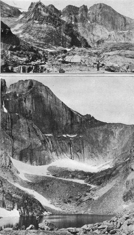
In the walls of this cirque may be found the key to the mystery of its origin. The rocks are composed of granite and schist. The face of Mount Meeker (Pl. XXXVI, A) shows that the older schists were fractured and that the younger granite was forced into them in more or less steeply inclined sheets. The younger sheets appear in the face of the cliffs as light-colored bands, some of them running to a thin edge, as if a huge wedge had been driven laterally into the mountain. The face of the main peak exhibits a somewhat different character, for the joint planes or cracks which divide the rocks into great slabs are here vertical or are very steeply inclined. This is conspicuously shown in The Notch (Pl. XLII) and may be seen also near The Keyhole, where the granite is split into huge steeply inclined slabs. The vertical eastern face of the peak is due largely to this vertical jointing of the rocks. The photograph of The Notch, showing the rock column parting from the parent cliff, illustrates one of the ways in which the ice plucked the rocks from the cliffs. If the ice filled the space behind such a column and was pressed downward by the weight of the ice above it, the column of rock would soon be wedged off. With this illustration before us, we may easily picture an ice wedge with 2,000 feet of ice pressing on it, driven into the cracks of the fractured rock, and splitting off the outer slabs.
|
|
PLATE XXXVI.
A (top). A DETAIL OF THE WALL OF THE CHASM.
Showing at the left the banding of the wall, caused by the varied
composition of the rock. The light-colored bands are granite, and the
dark-colored bands are schist. The vertical lines are surface stains due
to running water. B (bottom). CHASM LAKE AND LONGS PEAK. The lake covers 6 acres and lies at an altitude of 11,943 feet, 2,312 feet below the peak. At the foot of the precipice lies the small body of ice whose ancestor—Mills Glacier—S-shaped the cliffs and dug The Chasm. Photographs by Willis T. Lee, United States Geological Survey. |
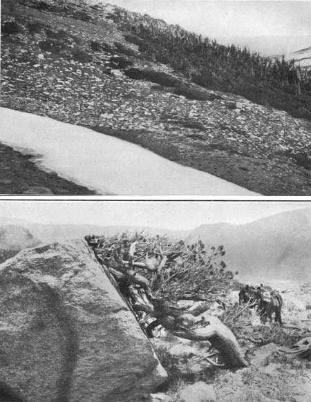
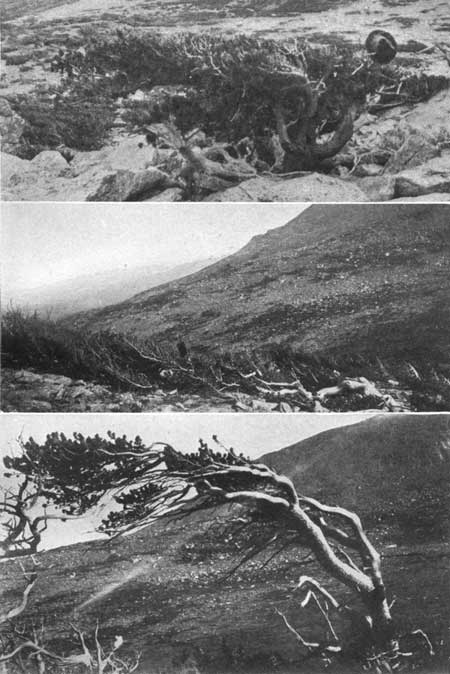
Timber-line trees.—It is said that there is no place in the Rocky Mountains where the curious gnarled and stunted trees which develop near timber line can be seen to better advantage than on the side of Longs Peak. The larger trees are limber pines and Engelmann spruces. The smaller ones commonly found are willows and black birch. The timber-line trees occupy a relatively narrow belt at an altitude of about 11,500 feet. The same species of trees which at lower altitudes grow tall and straight are here dwarfed and develop strangely gnarled and twisted characters. They have a hard struggle for life where the cold is excessive and where snow covers the ground much of the time, in some places never melting away (Pl. XXXVII, A). The strong winter winds tear the snowflakes into minute crystals of ice and hurl them with such force that they act in much the same way as sand in a sand blast. These snow blasts not only cut the bark from the windward side of the tree, thus preventing the growth of branches on that side, but cut away parts of the wood (see Pl. XXXVIII). They shear off the tender twigs that grew in exposed places during the previous summer, so that the trees have the appearance of being trimmed like an ornamental hedge. (See Pl. XXXVIII, upper.)
|
|
PLATE XXXVII.
A (top). TIMBER LINE ON LONGS PEAK.
Showing the great mass of snow and ice near Timber
Line Cabin and the highest part of the slope on which trees grow. The
relatively tall ones at the right are limber pines and Engelmann
spruces. Still higher on the slope these species are stunted and only a
few feet high. The "forests" of black birch and willow trees, about 6
inches high, form the dark-colored mats on the slope in the
foreground. B (bottom). A PINE TREE ABOUT 6 FEET HIGH AT TIMBER LINE SHELTERED BY A GLACIAL BOULDER. The west wind bent the twigs eastward so constantly that the branches grew crooked. The twigs were sheared off by the snow blasts so that the tree did not succeed in growing beyond the shelter of the rock. Photographs by Willis T. Lee, United States Geological Survey. |
|
|
PLATE XXXVIII.
TIMBER-LINE TREES ON LONGS PEAK, INCLINED TOWARD
THE EAST AWAY FROM THE PREVAILING WESTERLY WINDS. Upper, Tree rooted in a protected spot among the rocks sheared off even with the top of a sheltering bowlder by the wind-blown crystals of ice. Middle, "Where trees grow lying down." This is not a fallen tree, but one which began life in the lee of a protecting bowlder and grew along the ground, held close to earth during the greater part of each year by drifting snow. It is 20 feet long with branches 2 feet high. Lower, A tree well known to climbers on Longs Peak as "The Winged Victory." The bark is worn by the snow blasts from the west side of the trunk and branches, and the living twigs stretch eastward as if trying to avoid the storm. Photographs by Willis T. Lee, United States Geological Survey. |
In some places trees develop only where they are afforded special shelter (Pl. XXXVII, B), such as on the leeward side of a bowlder. The tendency of the snow blasts to cut away twigs and bark on the windward side causes the trees to develop leeward. Also the prevailing westerly wind bends them so that many have the appearance of stretching out in an easterly direction, as if trying to escape from constant annoyance (Pl. XXXVIII, lower). This tendency to grow in an easterly direction is carried to an extreme in some places. The accompanying illustration (Pl. XXXVIII, middle) shows one of many pine trees found near timber line lying flat on the ground. It is not a fallen tree but one which began life in the lee of a small bowlder. The wind bent the young shoots eastward and the snow held them flat on the ground though a large part of each year. Ambitious shoots which arose too high were sheared off by the snow-blasts. But in spite of all difficulties, this persevering pine succeeded in creeping 20 feet along the ground.
Timber-line trees grow slowly. It has been found by counting the annual rings that on the average a trunk or branch will increase in diameter about 1 inch in a century. In other words, it takes about 100 years for one of these trees to grow large enough to serve as the climbing staff which the tourist is fond of using. And yet some of these trees have trunks as much as 3 feet in diameter (Pl. XXVI, B, p. 61). Particularly interesting in this connection are the willow and birch "trees" which form the green mats on the mountain sides at timber line (Pl. XXXVII, A). The greater part of their bulk is underground, the exposed parts growing only a few inches above the surface. Some of these "trees" about 6 inches high have been determined as nearly 100 years old.
ASCENT OF LONGS PEAK.
Timberline Cabin is a convenient place from which to start for the top of Longs Peak, thus allowing the whole day for the ascent and affording plenty of time for enjoying the remarkable scenery. Soon after leaving the cabin we pass a group of the curious stunted trees just described. Close to the highest group is a large snow bank where the drifting snow gathers in a sheltered spot. This shelter is afforded by the terminal moraine of the small glacier which moved eastward from Boulder Field across the saddle between Mount Lady Washington and Battle Mountain and descended the slope as far as timber line. This slope above the snow field is covered with heaps of slightly worn glacial bowlders left there by the ice when this lobe of the glacier disappeared. Up the path of this glacier the trail winds to Boulder Field.
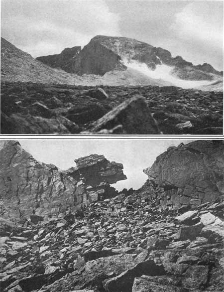
Boulder Field is a continuation of this débris-covered slope, but the greater part of the field is not so steep. As the name indicates, it is an area of scattered bowlders. The rocks are angular and only slightly worn, for they journeyed with the ice only the short distance between their present position and the peak from which they were derived. They vary greatly in shape and size. but such smaller fragments as may originally have been on the surface have been washed down into the spaces between larger bowlders, so that the surface is now occupied almost exclusively by the larger ones. The route (it can not be called a trail, for there is no path that can be followed) to the peak crosses these heaps of bowlders for fully a mile, Horses can not be ridden over them (Pl. XXXIX, A), and the feet of the tourists make little impression on the hard blocks of granite. It makes little difference what route we choose across this field. One is as good—or as bad—as another. We must step from rock to rock, always taking care that the bowlder we step on is firm. Many of them are so nicely balanced that the pressure of the foot will cause them to turn. Although we may not follow a trail, we have continually in view The Keyhole, the one opening though the rock ridge before us which we must pass in order to reach the peak (Pl. XXXIX, B).
|
|
PLATE XXXIX.
A (top). LONGS PEAK AND BOWLDER FIELD.
To the left is the slope of Mount Lady Washington and
the upper part of the eastern face of Longs Peak, overlooking The Chasm.
The snow field is a survival of the glacier that carried the bowlders
from the peak and dropped them on Boulder Field. The trail to Longs Peak
passes over these bowlders and through The Key hole, at the extreme
right. B (bottom). NEAR VIEW OF THE KEYHOLE AND THE ROCKY ROAD TO IT FROM BOULDER FIELD. SCENES ON LONGS PEAK. Photographs by Willis T. Lee, United States Geological Survey. |
The narrow and sharp-crested ridge in which The Keyhole is situated owes its existence to the structure of the rocks and to the action of glacial ice. The rock is broken into huge slabs which are vertical or steeply inclined. In days of old, when the upper portions of the mountain side were covered with ice, the water freezing between the slabs expanded as it always does on turning to ice and pried them apart. The ice forced between them by the weight of the overlying mass acted as a wedge to split them from the parent cliff, and the blocks thus loosened were carried away by the glacier. The earliest blocks to be loosened were carried to the end of the ancient glacier. The later ones were borne only part way down the slope before they were dropped by the melting ice. In this way Bowlder Field was formed.
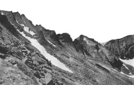
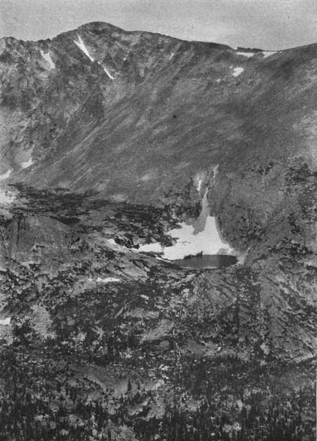
As we pass through The Keyhole there opens before us one of the most impressive scenes in the Rocky Mountain National Park. From this point of vantage we gaze into Glacier Gorge, an enormous steep-walled basin, whose floor at Lake Mills lies 4,255 feet below the highest point of its rim. Toward the north across the gorge rise the great walls of barren rock in the more protected portions of which lie fields of perpetual snow. To the left is The Trough (Pl. XL), a narrow, steeply inclined ice-filled gulch. Up this trough the climber must make his way to the top of Longs Peak. To the right, nearly 2,000 feet below The Keyhole, is Blue Lake. Still farther below is Black Lake, situated in a rock basin, walled in on thee sides by precipices and opening northward into the larger basin of Glacier Gorge proper. In the wall of the gorge opposite us, high on the side of Thatchtop Mountain, are several lakes occupying shelves or little pockets in the side of the mountain. Shelf Lake lies at the mouth of a small cirque tributary to Glacier Gorge, and the little unnamed lake to the north of it is a typical example of a pocket lake (Pl. XLI).
|
|
PLATE XL. THE HEAD OF GLACIER GORGE AS SEEN
FROM THE KEYHOLE.
To the left is the snow-filled Trough, up which the climber must make
his way to the summit of Longs Peak. Farther to the right is Chief's
Head Mountain and the serrate ridge separating Glacier Gorge from Wild
Basin. In the foreground to the right is the shelving surface worn on
the face of the inclined slabs of granite. Photograph by Willis T. Lee, United States Geological Survey. |
|
|
PLATE XLI. A POCKET LAKE IN THE WEST WALL OF
GLACIER GORGE.
Nearly 1,000 feet above the floor of the gorge. As seen from Keyhole, on
the Longs Peak trail, showing the remnant of the cliff glacier that
scooped this pocket out of the solid rock. Photograph by Willis T. Lee, United States Geological Survey. |
From Keyhole we make our way for a short distance across the steeply shelving rock on the west slope of the peak and enter the ice-filled Trough. Here the trail is steep, and climbing is attended with some danger, especially during seasons when steps must be cut in the ice. At other times the ascent is reasonably safe except from falling rocks loosened by some climber farther up the slope. But at best the climb is tiresome, for exertion at such high altitudes is exhausting. The Trough ends above at The Narrows, an opening through another sharp-crested ridge similar to that at The Keyhole. From The Narrows our path lies along a shelf in the face of a nearly vertical cliff (Pl. XLII). This shelf, which is the only practicable route to the peak, was formed by faulting of the rocks. The rocks were broken obliquely, and those above the break slipped downward and inward, leaving the rocks below the break projecting outward a few feet beyond those above it. Before us is The Notch (Pl. XLII), which is a conspicuous feature of the peak, as viewed from the east or from the south. Stretching before us toward the south lies Wild Basin, with its great variety of weird features and picturesque landscapes.
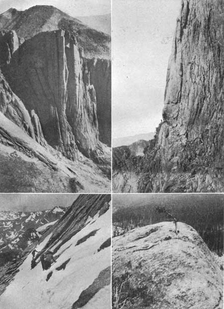
|
|
PLATE XLII. VIEWS NEAR THE TOP OF LONGS
PEAK. Upper left, The Notch, on Longs Peak, showing the vertical lines of cleavage in the rock. Water freezing in the cracks would in time break the slabs of rock from the face of the cliff. Also, ice filling a crack would act as a wedge when forced downward by the weight of ice accumulating above it. Photograph by Enos A. Mills. Upper right, The Narrows, on Longs Peak trail. The shelf in the side of the precipice must be traversed in order to reach the summit. This shelf was formed by faulting. A fault or great crack in the rocks extends diagonally downward to the right. The rocks above have slipped at this fault and have been displaced toward the right, leaving room for a pathway on the rocks below. Photograph by Enos A. Mills. Lower left, Home Stretch, on Longs Peak—the last steep climb before reaching the top. The climber must make his way cautiously along this stretch of insecure footing with the shelving face of the mountain above and a precipice below. Photograph by Frank W. Byerly. Lower right, A rock rounded and smoothed by the ice of Wild Basin Glacier. Photograph by Willis T. Lee, United States Geological Survey. |
At the end of the shelf we reach Home Stretch (Pl. XLII), where we must choose our footing with some care on the steeply shelving surface, for a false step here might dash us over the precipice below. The climb up this slope is the final effort before reaching the top, where we find a nearly flat surface about 1,500 feet long and 1,000 feet wide. Here we are on the highest point in the Rocky Mountain National Park and one of the highest in the whole range of the Rocky Mountains.
NORTH ST. VRAIN RIVER.
St. Vrain Valley is conveniently reached from Copeland Lake Lodge, situated at the point where the road between Ward and Estes Park crosses the river. Like many of the other valleys of the region, this one was glaciated. The ice from Wild Basin extended downstream to a point about a mile east of the road crossing. About a quarter of a mile east of this crossing the river begins its descent over the terminal moraine of this ancient glacier, and for about three-fourths of a mile there is a succession of picturesque rapids where the water swirls among the bowlders or dashes itself into foam against them. The scenes of varied beauty along this part of the river's course amply repay us for the small effort it requires to reach them. The water power here was utilized at one time in mining, and the old flume and power plant still remain.
Copeland Lake Lodge is situated near the lower end of the melting basin of the Wild Basin Glacier, and a short distance west of this lodge at the side of the valley is Copeland Lake (Pl. XLIII, A), a small body of water occupying a depression in the morainal material. Normally the lake is fed by springs, but water from one of the streams tributary to the St. Vrain is diverted into it. The beavers who make their home on this stream seem to resent this interference with the natural flow as an unwarranted infringement of their rights. It is said that they repeatedly construct dams across the artificial inlet, turning the water back where it naturally belongs. So persistent and industrious are these creatures that the owners of the lake are not always able to keep the basin filled with water.
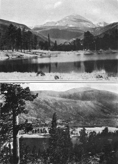
|
|
PLATE XLIII.
A (top). COPELAND LAKE, THE VALLEY OF THE NORTH ST. VRAIN, AND COPELAND
MOUNTAIN (13,176 feet). B (bottom). THE MELTING BASIN AND THE SOUTHERN LATERAL MORAINE OF WILD BASIN GLACIER. As seen from the top of Copeland Moraine at Copeland Lake. VIEWS IN THE VALLEY OF THE NORTH ST. VRAIN. Photographs by Willis T. Lee, United States Geological Survey. |
The nearly level floor of the melting basin (Pl. XLIII, B) contrasts sharply with the steep slopes of the high morainal ridges on either side. The one to the north, called Copeland Moraine, marks the northern extent of the great tongue of ice, The moraine south of the river is equally well defined but has not received a separate name. The character of these morainal ridges is readily recognized by their regularity in outline, the evenness of their cress, and their composition of various-sized bowlders. However, at the end of Meeker Ridge, south of Lookout, the mountain rock was not entirely covered by the ice-borne material.
WILD BASIN.
Wild Basin is usually entered from Copeland Lake Lodge. Near the head of this basin the valley narrows to a steep-walled gorge, the floor of which rises steeply to the west. Here the stream from Sandbeach Lake descends from the north over the rim of the moraine where a great landslide has occurred. Much of the morainal material has here slid into the bottom of the valley. The bowlders, added to those already in the bed of the stream, cause a series of rapids which add pleasing variety to the landscape. The trail is close to the stream in a few places where some of the most picturesque rapids occur, and such scenes of beauty as that depicted in Plate XLIV, B, are not uncommon.
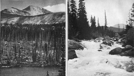
|
|
PLATE XLIV.
A (top). LONGS PEAK AS SEEN FROM THUNDER LAKE. B (bottom). RAPIDS IN NORTH ST. VRAIN RIVER. Where a large volume of glacial material slid into the valley from the lateral moraine of Wild Basin Glacier. VIEWS IN WILD BASIN. Photographs by Willis T. Lee, United States Geological Survey. |
West of the mouth of Cony Creek the trail becomes steeper, and the character of the surface changes from that of the bowlder-filled valley to the erosional type formed by the glacial ice moving over the solid rock. The rounded and polished surfaces are numerous and beautifully exposed (Pl. XLII, lower right) on the steep slope west of the mouth of Ouzel Creek. Above this steep slope we find one of the large parklike openings so common at high altitudes, the center of which is occupied by Thunder Lake (Pl. XLV). It is a large glacial cirque, and the steep slope on which the polished surfaces are so conspicuous is the path down which the rocks, gouged out of this cirque, were dragged by the moving ice. Its character is not so obvious to the casual observer as is that of some others in this park, because of the dense forests which obstruct the view.
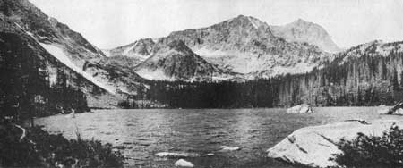
|
|
PLATE XLV. THUNDER LAKE AND MOUNT ALICE.
The lake lies at an altitude of 10,570 feet and has an area of 15 acres.
It is used to some extent as a reservoir in which water is conserved
for irrigation on the distant plains. The altitude of Mount Alice is 13,310
feet. Photograph by Willis T. Lee, United States Geological Survey. |
Wild Basin is appropriately named. It is so irregular in outline that to obtain good views of it one must ascend some commanding peak, such as Lookout (10,744 feet). From such a point of vantage it appears to equal, in varied beauty and wild splendor, the choicest scenery of the better-known parts of the park. Only a few of its scenic features can now be reached by trail, including Sandbeach Lake, Ouzel Lake, and a few others. When adequate trails are built and lodges established for the accommodation of tourists, Wild Basin will probably be one of the most attractive places in the Rocky Mountain National Park.
| <<< Previous | <<< Contents >>> | Next >>> |
sec3d.htm
Last Updated: 11-Dec-2006