


Survey of Historic Sites and Buildings
 |
ALTA Utah |
|
| ||
In 1864 soldiers found silver in Little Cottonwood Canyon, and 3 years later prospectors formed the mining camp of Alta on the side of Mount Baldy. After J. B. Woodman founded the Emma Mine in 1869, a boom occurred. The Emma shipped its ore in ox-drawn wagons to Ogden, from where it moved by rail to San Francisco and then by ship to Wales for smelting. In 1871 investors formed the Emma Mining Company of Utah. Within a few months Eastern investors poured $375,000 into the company, renamed the Emma Mining Company of New York, and it soon gained an international reputation. In 1872 British capitalists purchased it and again renamed it, as the Emma Silver Mining Company, Ltd., of London. That same year, however, cave-ins rendered the mine worthless.
The population of the town at the time was 5,000, and it included 2 breweries, 6 sawmills, and 26 saloons. After the Emma failed, most of the miners remained to work other veins. Between 1871 and 1877, the mines yielded more than $13 million in ore. In 1893, because of the decline in silver prices, mine after mine closed down. Several avalanches in the 1880's destroyed much of the town, but in 1904 prospectors found a new ore body and the town came back to life. Today it is a modern ski resort and has few remains from the mining days.
|
BINGHAM CANYON Utah |
|
| ||
As early as 1848 Mormons discovered gold and silver deposits in this canyon, but church officials feared the inevitable rush and prohibited dissemination of the information. In 1862, however, Col. Patrick E. Connor, Army commander of the District of Utah, learned of gold, silver, and lead deposits in the canyon and promptly broadcast the news. Prospectors rushed in and staked out the but completion of a railroad into the canyon made lode operations for silver and lead profitable. The drop in silver prices in 1893 brought silver and lead mining to a standstill, but a subsequent rise in the price of copper led to renewed interest in the district. In 1903 the Utah Copper Company was organized. Using open-pit mining methods, it has been operating in the canyon ever since. Today the town of Bingham Canyon looks like many other mountain mining towns. A single main street meanders up the canyon between houses perched on the flanking slopes.
NHL Designation: 11/13/66
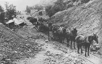 |
| Mining operations at Bingham Canyon, Utah. Loaded cars traveled from mines in the canyon by gravity to the smelter and depot in the valley. Horses pulled the empty cars back up to the mines. Courtesy, Utah State Historical Society. |
|
COVE FORT Utah |
|
| ||
Cove Fort, like Pipe Spring, was established under the direction of Brigham Young as a way station for travelers between the Mormon settlements of southern Utah and northern Arizona. Erected in 1867 by Ira N. Hinckley, it lay on a heavily traveled road that linked Salt Lake City with the Virgin River Valley of northwestern Arizona. Nearby Cove Creek supplied water for irrigating the truck gardens that provided produce. Constructed of basalt blocks laid with lime mortar, the fort consists of two rows of five rooms facing each other across a closed courtyard, whose walls are equipped with loopholes and firing parapets. It is open to the public.
|
GOODYEAR CABIN Utah |
|
| ||
This cabin commemorates the activities of mountain man Miles Goodyear, who founded the first permanent settlement by whites in Utah west of the Wasatch Mountains, and was one of the first to carry on agricultural pursuits. It was part of a trading post called Fort Buenaventura, which in 1846 Goodyear established on the Weber River on the site of Ogden. When the Mormons arrived in the Great Salt Lake basin in 1847, they persuaded Goodyear to sell out. Capt. James Brown and his family, the new occupants, extended Goodyear's cultivated acreage. A cottonwood log cabin that once was a part of Fort Buenaventura is still standing. It has been moved from the original site, near the Union Pacific depot in Ogden, to Tabernacle Park.
|
MORMON IRRIGATION SITES Utah |
|
| ||
The Mormons were the first Anglo-Saxons to irrigate extensively in the West and make the desert bloom. They introduced irrigation wherever they settled and influenced others to do likewise. Arriving in the Great Salt Lake basin in 1847 and finding the soil too dry to plow, they immediately built a dam at one of the two nearby creeks flowing down from the Wasatch Mountains and diverted the water to their fields. Soon the farms prospered.
Rejecting the English common law system of riparian rights and drawing on the Spanish Doctrine of Appropriation, the Mormons developed a policy of land survey and distribution of water based on individual need and capacity. All fields adjoined an irrigation ditch connected with the main creek. A committee planned the principal ditches, whose construction was participated in by all users on the basis of the amount of land tilled. Each farmer then dug smaller trenches to his own plot. The church rigidly controlled use of the water, and each farmer received just enough for his needs.
The original irrigation sites, along what is now City Creek in downtown Salt Lake City, have been obliterated. In the heart of the city, however, stands a monument, executed by the Utah sculptor Mahonri Young, commemorating the Mormon irrigation achievement.
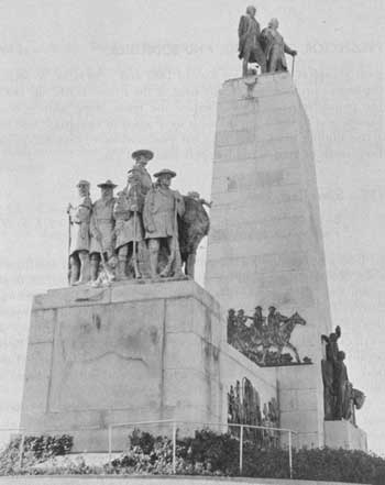 |
| Pioneer Monument, at the mouth of Emigration Canyon, Salt Lake City, pays tribute to all Utah pioneers, especially the hardy Mormons who settled in the Great Basin and made it bloom. |
|
PARK CITY Utah |
|
| ||
In 1869 some soldiers stumbled onto silver, lead, and gold deposits near the site of this town. The following year they opened the Flagstaff Mine, and miners poured into the area. A line of tents and shacks at the bottom of Provo Canyon became the camp of Park City. The Ontario Mine, staked out in 1872, brought in substantial capital. Even major fires in 1882 and 1898 failed to retard the town's progress and by the time of the silver "crash," in 1893, the population was 6,000. Despite the crash, some mining continued, and by 1915 several mills were again in operation. Still an active mining town, Park City has produced more than $250 million worth of gold, silver, copper, lead, and zinc.
|
SILVER REEF Utah |
|
| ||
In 1866 a prospector discovered silver in the vicinity of the future town of Silver Reef, but he did not develop his find until 1870, at which time he and some friends formed the Harrisburg Mining District and began small-scale operations. In 1874, when prospectors staked out the Leeds claim on White Reef, a sandstone ledge, a small camp originated nearby that came to be known as Silver Reef because of the numerous silver strikes in the area. It reached its peak between 1877 and 1880, when stores and hotels, a bank, a church, and a Wells-Fargo office lined the busy street.
By 1880 a few companies owned most of the mines. The next year the price of silver fell, water seeped into the mines, and stockholders demanded a cut in miners' wages—resulting in a conflict that led to lessee operation of the mines. Between the years 1892 and 1903, the mines shipped $250,000 worth of bullion and produced a total of $10-1/2 million worth of silver ore. Today the town is in ruins. Rotted wooden sidewalks, remnants of adobe and stone walls, and sage-clogged streets characterize the landscape.
 |
 |
http://www.cr.nps.gov/history/online_books/prospector-cowhand-sodbuster/sited15.htm
Last Updated: 22-May-2005