


Survey of Historic Sites and Buildings
 |
CLARENDON Texas |
|
| ||
One of the earliest settlements in the Texas Panhandle, Clarendon was founded as a temperance colony in 1878 by Lewis H. Carhart, a Methodist minister. The cowboys dubbed it "Saint's Roost" because deeds contained prohibition clauses. Surrounded by huge ranches, the town became the commercial center of the county. A stageline provided service to Dodge City. When the Fort Worth and Denver Railroad bypassed the town in the late 1880's, the residents abandoned it and established a new settlement 6 miles to the south on the rail line. The site of the old town lies on the Bugbee Ranch, north of New Clarendon. The sole surviving structure, a one-story framehouse, has been moved to the Bugbee Ranch headquarters.
|
FORT GRIFFIN Texas |
|
| ||
Established by Col. Samuel D. Sturgis in 1867 on a hill overlooking the valley of the Clear Fork of the Brazos River, Fort Griffin became a link in the chain of military posts along the Texas frontier. At the bottom of the hill grew a wide-open frontier town, known as The Flat, whose visitors included outlaws such as Billy the Kid and lawmen such as Bat Masterson and Pat Garrett. Supply and shipping center for a section of the southern Plains buffalo country, it shipped bales of hides to Eastern markets. As the buffalo hunters completed their slaughter and troops from the fort pacified the Plains, Goodnight, Loving, Adams, and other well-known cattlemen pushed their holdings northwest from the town. In 1881 the Army abandoned the fort, which had been of lesser importance than its sister forts on the northwest frontier of Texas, Forts Concho and Richardson, and the town declined.
Fort Griffin is today a State park. A few remains of the fort may be seen, and the sites of some of the buildings are marked. A granite shaft erected by the Texas Centennial Commission in 1936 stands in the center of the parade ground. Ruins of the nearby town, which is in private ownership, are particularly interesting.
|
HORSEHEAD CROSSING Texas |
|
| ||
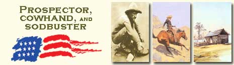
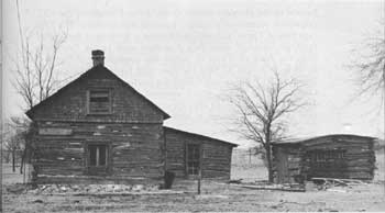
This crossing of the Pecos River was a landmark on the Goodnight-Loving Trail, but it was known and used long before the Texas cattle drives, perhaps even by early Spanish explorers. It was traversed by Indians following the Great Comanche War Trail to and from Mexico; forty-niners, emigrants, and surveyors; passengers on the Butterfield Overland Mail route; Texas cattlemen driving herds to California to feed the miners after the 1849 gold rush; U.S. Army troops transporting supplies to military posts and Indian agencies in Arizona and New Mexico; and Texas cowboys driving feeder stock to the northern and western ranges over the Goodnight-Loving Trail. Charles Goodnight and Oliver Loving had blazed the trail in 1866 from central Texas into New Mexico and Colorado Territories.
In private ownership today, the crossing is in much the same condition as it was in cattle-drive days. Isolated from main travel routes, it is virtually lost in the barren desert.
 |
| Modern view of Horsehead Crossing, Texas, well-known landmark on the Goodnight-Loving Trail, used not only by Texas cattle drovers but also by Indians, forty-niners, emigrants, surveyors, and U.S. Army troops. |
|
MATADOR RANCH Texas |
|
| ||
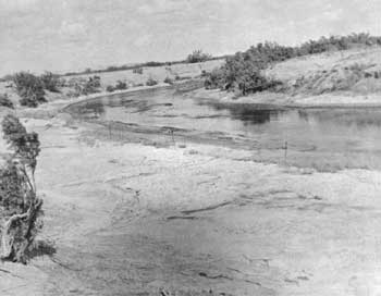
This ranch was founded in 1879 when H. H. Campbell and A. M. Britton formed a partnership, acquired range rights from a buffalo hunter, and bought 8,000 head of cattle. Prospering until 1882, they sold the ranch to the Matador Land and Cattle Company, Ltd., of Dundee, Scotland. Under the management of Murdo Mackenzie, the Matador became one of the largest enterprises in Texas. By 1910 the company owned 861,000 acres in Texas and had leased another 650,000 acres to the north. Some 66,000 head of cattle stocked these ranges. During a time of heavy British investment in American cattle, the Matador was one of the most successful of the British-owned ranches. In 1951 Lazard Brothers, an American syndicate, bought the ranch, which has since been subdivided.
 |
| Group of Matador Ranch cowhands. Texas cowboys made substantial contributions to the open range cattle industry. Courtesy, Russel Jones, Photographer, Jacksboro, Texas. |
The core of the old ranch, occupying 190 sections, is now owned by Fred C. Koch of Wichita, Kans. Only four buildings now extant antedate 1906: An old stone bunkhouse; a deserted stone icehouse; ruins of a windmill, milkhouse, and wellhouse; and a small white frame building. The major complex of stone buildings now at the ranch headquarters was built in 1918 by the Scotch owners.
 |
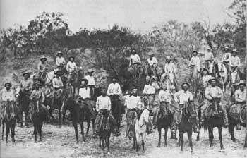
| Hard-working cowhands always welcomed mealtime. Scene on the Matador Ranch, Texas, about 1900. Courtesy, Russel Jones, Photographer, Jacksboro, Texas. |
|
MOBEETIE (OLD) Texas |
|
| ||
Mobeetie was an active trading and social center of the cattle country in the Texas Panhandle. In the 1880's it vied with Tascosa for the reputation of the toughest town in the region. Originating as a trading post in 1875 to serve the troops at nearby Fort Elliott, by 1879 it had grown into a village, populated largely by gamblers, dancehall people, and buffalo hunters; and had become the county seat of the newly organized Wheeler County. A damaging storm in 1898 and failure to obtain railroad service caused the town to decline, and in 1907 Wheeler gained the county seat. When the Panhandle and Santa Fe Railroad bypassed Mobeetie in 1929, a new town sprang up 2 miles to the north, and the old one became a ghost town. The stone jail, built in 1886, is the principal surviving building.
|
T-ANCHOR RANCH Texas |
|
| ||
The second ranch in the Texas Panhandle, established the year after the JA Ranch, the T-Anchor was founded in 1877 by Leigh Dyer, brother-in-law of Charles Goodnight. Dyer used timber from Palo Duro Canyon to construct the first log cabin in the Panhandle. The following year he sold the ranch to the firm of Gunter, Munson, and Summerfield, which in 1883 sold it to an English firm, the Cedar Valley Lands and Cattle Company. At the time the T-Anchor consisted of 225 sections of land and 24,000 head of cattle. In 1902 the owners divided the ranch into small sections and sold them to farmers and ranchers.
Dyer's simple log cabin still stands on 80 acres of the T-Anchor land, owned and operated by West Texas State University as an experimental farm. The cabin is maintained under the supervision of the Panhandle-Plains Historical Society of Canyon.
 |
| Early ranches were primitive by today's standards. The T-Anchor Ranch was founded in 1877 by Leigh Dyer, a brother-in-law of Charles Goodnight. The ranchhouse is preserved by the Panhandle-Plains Historical Society of Canyon, Texas. |
|
TASCOSA Texas |
|
| ||
Tascosa, now a ghost town, was formerly one of the liveliest and toughest towns in the Texas Panhandle, a distinction that it shared with Mobeetie. It originated as a sheep camp that was called Plaza Atascosa. In 1876 a blacksmith shop and general store opened for business, followed quickly by a saloon that served the thirsty riders on the cattle and freight trail that crossed the Canadian River at Tascosa Ford. Some of the riders were Pat Garrett, Bat Masterson, Billy the Kid, Charlie Siringo, and Frank James. Bypassed by the Fort Worth and Denver City Railroad in 1887, the town was abandoned. In 1939 the Maverick Boys' Ranch took over the site and for a headquarters utilized the old courthouse building, an original stone structure. The boys have marked the foundations of buildings and indicated their former uses. Visitors are welcome.
|
XIT RANCH Texas |
|
| ||
Largest of the pioneer ranches in the Texas Panhandle, the XIT originated because of a unique financial arrangement. The Chicago firm of Taylor, Babcock, and Company, founder of the Capitol Syndicate, received more than 3 million acres in the Panhandle from the State of Texas in return for constructing the capitol building in Austin. In 1885 the firm, with English backing, established the XIT Ranch and located the headquarters in the town of Channing. The ranch, which consisted of seven divisions, ran 110,721 head of cattle. In 1887 the company set up a branch operation in Montana, where it sent cattle each year for finishing. Though prospering at first, in 1901 it began to sell land to meet its financial obligations. By 1912 it had disposed of its assets to small ranchers and farmers.
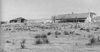 |
| Surviving buildings of the Escarbada Division Headquarters of the XIT ("Ten in Texas")—one of the most famous ranches in Western history. The XIT encompassed 10 counties. |
The headquarters building at Channing still stands and is used as a private residence, but it has been altered beyond recognition. In the 1890's Escarbada was a lively division headquarters. The foreman and his hands lived in a two-story plastered stone building that still stands on the present Reinauer Brothers Ranch.
 |
 |
http://www.cr.nps.gov/history/online_books/prospector-cowhand-sodbuster/sited14.htm
Last Updated: 22-May-2005