


Survey of Historic Sites and Buildings
 |
CLARK CABIN Washington |
|
| ||
This cabin was erected in 1859 by Ransom Clark, a farmer who supplied produce to nearby Fort Walla Walla, established 3 years earlier. The market broadened greatly in 1860 when prospectors struck gold at Orofino. By 1862 Walla Walla was an outfitting center, as well as a winter home for Idaho miners. The cabin is an excellent example of a pioneer farm home in the Northwest. It is a one-story structure that consists of two rooms, separated by a breezeway. This style of pioneer architecture is known as the "dog-run." The original fireplaces have been removed from the cabin, which has been moved about 100 feet from its original location.
|
CONCONULLY Washington |
|
| ||
In 1886 two prospectors, who had earlier discovered gold along the edge of Salmon Creek, began working the Homestake and Toughnut Mines above the town of Ruby. Their activity lured others, and within a few months Salmon City came into existence. It grew fast because of the abundance of water and the richness of the diggings, and in 1888 was renamed Conconully. In that year it lost a battle with Ruby for the county seat. Suffering many disasters, including a fire in 1892, a flood in 1894, and a depression in 1893, it never fully recovered. Since 1915 it has had only a small population.
|
COWLITZ FARM Washington |
|
| ||
The Hudson's Bay Company contributed substantially to the development of farming in the Northwest by forming, in 1839, a subsidiary, known as the Puget's Sound Agricultural Company. One of two farms the company established, Cowlitz was highly successful. In 1841 it produced 8,000 bushels of wheat and 4,000 bushels of oats, as well as barley, peas, and potatoes, on nearly 1,000 fenced acres. The farm was in operation until 1853-54, when armed American settlers took possession and the British withdrew. In 1869 the United States awarded the Hudson's Bay Company $200,000 as compensation for the farm property. The area is still devoted to farming, but no buildings of the Cowlitz Farm have survived.
|
FORT NISQUALLY Washington |
|
| ||
Fort Nisqually (Nesqually) farm, founded in 1840, was one of two established by the Puget's Sound Agricultural Company, a subsidiary of the Hudson's Bay Company. The fort, built in 1833 by Archibald McDonald as a fur-trading post and shipping center, had been the first permanent white settlement on Puget Sound. Soon the Fort Nisqually farm was operating a large dairy, running several hundred head of cattle, and growing wheat, peas, and oats. In 1845, when the herds included 2,280 cattle and 5,872 sheep, the farm exported to England nearly 10,000 pounds of wool, as well as hides, horns, and tallow. That same year the first Americans arrived in the vicinity, founded farms at Tumwater, and soon began encroaching on Fort Nisqually land, but the Hudson's Bay Company retained possession of the farm until 1869, when the United States acquired it, along with Cowlitz Farm.
The original site of Fort Nisqually—at Dupont, about 15 miles south of Tacoma on Sequalachew Creek—is now marked by a small granite monument. There are no surface remains, but two original log buildings, the factor's house and the granary, are now exhibited at Point Defiance Park in Tacoma. These two buildings are the only surviving examples of Hudson's Bay Company structures in the United States. Eight other buildings, two blockhouses, and the stockade have been reconstructed in the park.
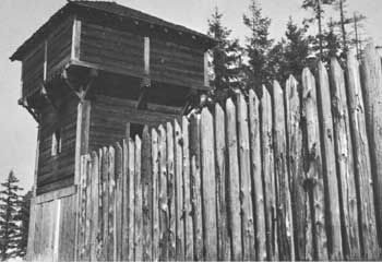 |
| At Fort Nisqually the Puget's Sound Agricultural Company, a subsidiary of the English Hudson's Bay Company, raised cattle, sheep, and garden produce—long before Americans settled in the Northwest. Pictured here is a reconstructed blockhouse and the stockade, located in Point Defiance Park, Tacoma, Washington. |
|
JACKSON CABIN Washington |
|
| ||
This cabin was the home of the first American settler north of the Columbia River, John R. Jackson, a native of England who arrived in the Oregon country in 1844 and staked out a claim about 10 miles north of Cowlitz Farm. In 1847-48 he completed a small cabin and eventually acquired some 2,200 acres of land. He raised grain, vegetables, and livestock for market, kept a public house, and participated in politics. In 1851 a group of American settlers met at his house, which had been converted to a courthouse the previous year, and began agitation for Territorial status. Jackson died in 1873.
In 1915 the cabin was donated to the Washington State Historical Society, which has restored it as a museum and historic home. One-and-a-half stories high, it is built of peeled logs with hand-split cedar boards above the first floor and a long, low porch across the front.
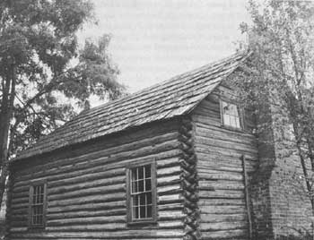 |
| John R. Jackson was the first American to settle north of the Columbia River, in 1844, and 4 years later he completed his cabin, which has been restored. In 1851 a group of American settlers met at the cabin, then used as a courthouse, to agitate for Territorial status. |
|
OLD FORT COLVILE SITE Washington |
|
| ||
Old Fort Colvile, also known as Fort Colville, was a fur-trading post, agricultural colony, and important way station of the Hudson's Bay Company. Named after Andrew W. Colvile, a governor of the Northern Department, and built in 1825 to complete the line of posts linking the company's forts in Canada with those in the Oregon country, it became the central supply post for all the forts in present northeastern Washington and the first agricultural center there. Consisting of high picket walls, equipped with bastions, it was well prepared to withstand Indian attacks. Within the walls were dwellings and storehouses.
In 1855, after the discovery of gold in the vicinity, Americans began arriving. When the gold supply there and in nearby British Columbia ran out, the disappointed miners turned to other endeavors. Some chose to farm and squatted on Fort Colvile lands. The Hudson's Bay Company, however, did not withdraw from the post until 1871, when the U.S. Government paid its claims. The site of old Fort Colvile has been inundated by Franklin D. Roosevelt Lake. A few remains of new Fort Colville, a U.S. Army post established in 1859, may be seen 3 miles west of the town of Colville.
|
REPUBLIC Washington |
|
| ||
When the discovery of gold on Granite Creek in 1896 near the site of this town caused the northern section of the Colville Indian Reservation to be opened to miners, a rush occurred and a lively tent camp sprang up that was first called Eureka and then Republic after the leading mine. It soon included 50 log and canvas shacks, 5 stores, 3 blacksmith shops, numerous other businesses, 3 assay offices, and several saloons. As early as 1900 it was one of the largest towns in eastern Washington and included 28 saloons, an opera house, and many balconied false-fronted stores. Stage service connected it with Spokane and other points. In recent years half of the State's silver output has been mined in the vicinity. A fire in 1938 destroyed most of the picturesque landmarks of the early period, and the modern town shows little evidence of its origin.
|
RUBY Washington |
|
| ||
Early prospectors illegally operated in the area of Ruby Mountain on the Moses Indian Reservation, but the real rush came after 1886, when the Government opened the reservation as part of the public domain. More than a thousand prospectors rushed in and struck silver and small amounts of gold. In 1887 they organized the Ruby Mining District. The associated town grew rapidly until stores and log houses lined both sides of a 1/4-mile-long street. It became the county seat after a clash with nearby Conconully and continued to prosper until 1893, when the silver market collapsed. After the population departed, ranchers removed or tore down most of the buildings, and a fire in 1900 destroyed most of the remains. Today only a line of weathered foundations, hidden in brush and grass, indicate Ruby's main thoroughfare.
|
SNIPES CABIN Washington |
|
| ||
Benjamin E. Snipes, one of the early cattle kings of Washington, was a North Carolinian who arrived in 1854 at The Dalles, Oregon Territory. The following year he acquired a small herd of cattle from an Army captain at Fort Dalles and obtained a range in the Horse Heaven Hills in Washington Territory. Four times—in 1856, 1861, 1862, and 1863—he made 800-mile drives to the mines in British Columbia to sell his beef to the gold seekers. He supplied U.S. Army Forts Dalles, Simcoe, and Walla Walla. To feed his cattle during the winters, he developed a series of hay ranches between the Yakima and Columbia Rivers, so situated that his control of the water gave him uncontested use of thousands of acres of public land.
In 1864 Snipes married and 3 years later built a fine two-story brick house at The Dalles, which fire destroyed in 1886. That same year he began investing heavily in Seattle real estate, and built and resided in a large home at 11th and Madison Streets. Next venturing into banking, he established banks at Ellensburg and at Roslyn. The Panic of 1893 swept away his fortune, estimated at $1 million, and he returned to The Dalles, where he died in 1906.
Snipes' ranching headquarters had been located on the north bank of the Yakima River at the base of Snipes Mountain, about 8 miles southwest of Sunnyside. The original ranchhouse, erected in 1859, was a crude one-story log cabin, which had mud-plastered walls and a sod roof. Removed from its original site, it is now exhibited in Sunnyside City Park.
 |
 |
http://www.cr.nps.gov/history/online_books/prospector-cowhand-sodbuster/sited16.htm
Last Updated: 22-May-2005