


Survey of Historic Sites and Buildings
 |
CENTRAL CITY South Dakota |
|
| ||
In 1877 several mining towns in the Black Hills that had a combined population of 10,000 assumed the common name of Central City, although one town in the group became known as Central City. Having a population of 3,000, it included 4 newspapers, 16 mills that were in operation night and day during the boom years, and many other businesses. Its residents organized the first public school system in Dakota Territory. In 1883 Deadwood Creek flooded and washed away the placer workings. Soon afterwards a fire broke out and destroyed a large part of the town, parts of which its residents never rebuilt. Today some deep stone foundations may be seen in lots that are overgrown with weeds. Only a small number of buildings survive from the era of mining operations. These buildings, which provide the town with some degree of historic atmosphere, sit amidst modern structures.
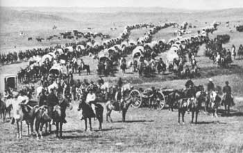 |
| The Custer expedition en route to the Black Hills in 1874. For years prospectors had heard rumors that the Black Hills contained gold. The expedition confirmed the rumors and set off the last great rush of the mining frontier. Courtesy, National Archives. |
|
CUSTER South Dakota |
|
| ||
The oldest town in the Black Hills and the first boomtown in the State, Custer is located on French Creek near the site where in 1874 Horatio N. Ross discovered gold. Ross was a prospector accompanying Gen. George A. Custer's expedition that explored Dakota Territory. Even though the Sioux Indians had possession of the area, the next year prospectors moved in and established a camp known as Stonewall, in honor of "Stonewall" Jackson. The U.S. Army, which occupied the area, ordered them to leave. In December 1875, when the troops withdrew, the miners returned and formed the town of Custer; and 2 years later the Government signed a treaty with the Indians.
In 1876 the population of the town was 5,000, but after the discovery of profitable placer mines at Deadwood it dwindled to less than 100. Settlers were later attracted to the area, however, and the arrival of the Burlington Railroad in 1890 fostered the town's development. Only a few early structures have survived, but several monuments commemorate the early days.
|
GALENA South Dakota |
|
| ||
A group of prospectors who sought placer gold but found rich veins of silver instead founded Galena in 1876. They staked out two claims, the Florence and the Sitting Bull. Despite the opening of mills and a small smelter, the town grew slowly because of its isolation. A legal battle in the 1880's over mining properties brought about its demise. A brief revival occurred between 1895 and 1897, when silver prices were high. Later the town was a summer resort, but now has only a few residents.
|
HILL CITY South Dakota |
|
| ||
Founded in 1876, the year after prospectors struck gold along Spring Creek, this town had hardly been established when news of the gold strike at Deadwood depleted its population. Some of the miners later began to drift back and discovered gold lodes, a few ranchers settled in the valley, and the town started to grow once again. In 1883 prospectors found tin in the vicinity and staked out claims. An English corporation, the Harney Peak Consolidated Tin Company, bought up all the promising claims, but after a few months of successful mining operations in 1892 abandoned the area. Most of the population drifted away, but in modern times the town revived.
|
ROCHFORD South Dakota |
|
| ||
In 1876 three hunters from Deadwood accidentally discovered deposits of gold in the vicinity of this village. Soon swarms of prospectors arrived and formed a mining district and the town of Rochford. Some 500 resided in the town and 500 more camped in the nearby hills. By 1879 two 20-stamp mills, the Evangeline and the Minnesota, were operating in the vicinity. The Standby Mine, which had a 40-stamp mill and other elaborate facilities, was the most extensively developed property. The town consisted of more than 200 buildings. In the 1880's the mills closed down and most of the residents departed. A few ruins of gold-rush buildings may be seen in the modern town.
|
ROCKERVILLE South Dakota |
|
| ||
This town was second only to Deadwood in Dakota Territory in the richness of its gold placers. In 1876, not long after a prospector found gold in the vicinity, a stampede of miners occurred. During the dry winter season they had to transport their rockers by hand cart to the nearest pool or stream to rock out their load. During the rest of the year hundreds of rockers were in use along the banks of Rockerville Gulch.
In 1880, when operations reached their peak, the Black Hills Placer Mining Company laid a flume to the diggings from a dam 2 miles above Sheridan, 15 miles away. The flume, in operation for 2 years, made possible the recovery of $500,000 worth of gold. In 1881 the Rockerville Gold Mining Company built a 1,100-foot bedrock flume on the hill below the town, but it was unsuccessful. By 1883, mining had practically ceased, and the camp had been deserted. Today only a dilapidated cabin and a few other remains may be seen in the ghost town of Rockerville.
|
ROUBAIX South Dakota |
|
| ||
In 1876 prospectors struck gold on the banks of Elk Creek near the site of the town of Perry, later renamed Roubaix. A one-stamp mill served the Uncle Sam Mine. In 1880, after the mine had changed hands several times, its owners closed it down when it filled with water. The town almost died. In 1899 Pierre Wibaux, a wealthy Frenchman, arrived and took possession of the Uncle Sam, which he operated under the name of the Clover Leaf Mining Company. He renamed the reinvigorated Perry for his hometown in France, Roubaix. After only a few years of profitable operation, however, the mine again flooded and Wibaux was forced to abandon it. A fire destroyed many of the buildings, and the mine was not operated again except for a brief period in the 1930's by the Anaconda Copper Company. In 1947 it was sold for taxes. Only a few people live in the town today.
|
SHERIDAN (lost site) South Dakota |
|
| ||
This town originated in 1875 as a mining camp called Golden City after prospectors discovered placers in the meadows along Spring Creek. The very next year the residents chose a new name, Sheridan. The town became the county seat and accommodated the first Federal court west of the Missouri River. It was an important station on the Deadwood-Denver stageline and a regular stopping place for Brig. Gen. George Crook and his troops on their patrols through the Black Hills. Rapid City acquired the county seat in 1878, the coming of the railroads brought about the demise of the stage business, and the productivity of the placers in the vicinity lessened. Sheridan became a ghost town. In 1938 construction of a dam across Spring Creek started and the reservoir, Sheridan Lake, submerged the town.
 |
 |
http://www.cr.nps.gov/history/online_books/prospector-cowhand-sodbuster/sited13.htm
Last Updated: 22-May-2005