


Survey of
Historic Sites and Buildings
DESPITE all the damage, in places the route of Lewis and Clark remains much as it was. Providentially, one of the most spectacular parts of the Missouri River has not only been spared, but also in the region man's imprint is slight. This is the 180-mile length of free-flowing, almost pristine waters lying between the upper reaches of the Fort Peck Reservoir and the Montana Power Company's Morony Dam, near the eastern end of the expedition's Great Falls portage. Within this span, east of the city of Fort Benton, is the picturesque badlands known as the Missouri River Breaks. Particularly notable is its western part, the 55-mile-long White Cliffs section, where nature-sculpted forms rise hundreds of feet in the eroded bluffs above the serpentine stream.
Beyond the city of Great Falls, the 84 miles of undisturbed terrain to Holter Dam is a delightful reach of river, canyon, plain, and mountain. Highway I-15 never runs far from the stream, and in places immediately alongside it. In this area, one can follow the nautical progress of the expedition—but on wheels. At the Three Forks of the Missouri, Mont., not far south of the Holter-Hauser-Canyon Ferry dam complex, manmade and natural changes have been minimal, both in the river course and the surrounding vicinity.
Another relatively virginal expanse is the high Bitterroot Range country of Idaho along the Lolo Trail. There, modern visitors can still see the western wilderness through the explorers' eyes. Lemhi Pass is also still essentially unspoiled, as are various other sites such as Travelers Rest and Lewis and Clark Pass. Unurbanized and non-industrialized sections of the Lower Missouri and the Lower Columbia below Bonneville Dam, as well as other rivers in the Columbia and Missouri drainage systems, occasionally offer vistas that Lewis and Clark might recognize.
The Yellowstone River Valley, though various cities, towns, ranches, farms, railroads, and highways are scattered along it, has not yet been unduly affected by modern development. The stream itself is essentially wild and is unobstructed by dams. Pompeys Pillar, along the river about 28 miles east of Billings, is as much a landmark in this day as when Clark climbed it on July 25, 1806, and carved his name and date on its eastern face. That inscription, though once partly disfigured and twice deepened, is still readable.
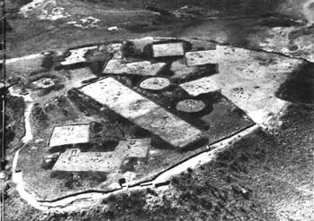 |
| Example of excavation accomplished by the Missouri River Basin Survey before much of the Middle Missouri River Valley was inundated by dam construction in the 1960's. This photograph shows Nightwalker's Butte in the Bull Pasture Site (32ML39), Lake Sakakawea (Garrison Reservoir), N. Dak. This was an early 19th-century earthlodge village, located atop a small, high butte, that was surrounded by a fortification palisade. The small black dots are post holes indicating outlines of houses. (River Basin Surveys, Smithsonian Institution.) |
THUS, only in a few places can a modern American see the western wilderness for any considerable distance in essence as Lewis and Clark saw it. But even some of the few remaining areas remindful of one of America's greatest explorations are threatened.
Historic preservationists and environmentalists, with the support of Congress, have recently headed off a plan to construct the High Cow Creek Dam, which would flood the Missouri River Breaks. The Yellowstone River Valley is imperiled by the recent growth of strip mining among the huge low-sulphur coal deposits in eastern Montana and northern Wyoming. In this "Ruhr of the Northwest," as it is already being called, a giant generating complex that would utilize new dams on the Yellowstone, Bighorn, and Tongue Rivers has been proposed.
Conservationists hope that Congress will declare the Missouri River Breaks, the Yellowstone, and other similarly endangered streams or parts of streams as "wild" or "scenic" rivers so that posterity may enjoy them. (149 miles of the Upper Missouri River were designated a National Wild and Scenic River in 1976, and were subsequently declared a National Monument in 2001).
NUMEROUS governmental and private agencies, as well as individuals, are engaged in commemorating Lewis and Clark sites. An exemplary program was that of the congressionally authorized Lewis and Clark Trail Commission (1964-69). The 28-man body, chaired by Sherry R. Fisher, prominent Des Moines banker, consisted of representatives of Illinois, Missouri, Kansas, Iowa, Nebraska, South and North Dakota, Montana, Idaho, Washington, and Oregon; 4 U.S. Representatives; 4 Senators; representatives of the Interior, Agriculture, Defense, Health-Education-Welfare, and Commerce Departments; and 4 from the J. N. "Ding" Darling Foundation. The latter had been the catalyst that spurred the entire movement in 1962 by recommending a "Lewis and Clark Trail" to the Secretary of the Interior. The Bureau of Outdoor Recreation immediately began work with the appropriate States and various other governmental units to give life to the concept.
In 1961 J. N. ("Ding") Darling, cartoonist-conservationist for the Des Moines Register and for many years a director of the Izaak Walton League, had conceived a plan to create the trail and to improve, establish, and link up historical, recreational, and conservationist sites along it. Following his death soon thereafter, friends and associates founded the J. N. "Ding" Darling Foundation to advance the conservation principles he had espoused. The foundation chose the Lewis and Clark proposal as one of its first projects.
The accomplishments of the Lewis and Clark Trail Commission were extensive. To mark the trail highways, it devised a distinctive emblem that consisted of the standing silhouettes of the two explorers over the words "Lewis and Clark Trail." Among its many activities, the commission also aided the States in founding Lewis and Clark Trail Committees; and collected and disseminated information on Federal, State, county, municipal, corporate, and private plans and programs along the route. These included the surveying, identification, marking, and preservation of pertinent sites; sponsorship and production of publications, movies, and television and slide presentations dealing with the expedition; and improvement and construction of parks, recreational areas, and roads and trails.
When the commission expired in 1969, its functions were continued by the Lewis and Clark Trail Heritage Foundation, Inc., a private, nonprofit organization. It was organized in 1968 by the State Committee of the Lewis and Clark Trail Commission and included many of the latter's members and supporters. Most of the State Lewis and Clark Trail Committees, which had operated under the commission, remained in existence.
Also active in interpreting the Lewis and Clark Expedition to the public, in addition to the National Park Service, are the Department of the Interior's Bureau of Outdoor Recreation and Bureau of Sport Fisheries and Wildlife, the Army Corps of Engineers of the Department of Defense, and the Department of Agriculture's U.S. Forest Service, plus various State and local agencies and historical societies. They all rely principally on markers, publications, lectures, and other audiovisual programs.
HOMAGE has also been paid to the explorers by the placenames that dot the West, such as those of cities, counties, streets, highways, parks, recreational areas, lakes, reservoirs, and bridges—not to mention business establishments and civic organizations. Of particular note are the twin cities of Lewiston, Idaho, and Clarkston, Wash.; Lewis and Clark College, Portland, Oreg.; Lewis and Clark National Forest, Mont.; Lewis and Clark Lake (Gavins Point Dam reservoir), S. Dak.; Clark Fork of the Columbia River; and the Lewis and Clark River. Honoring others on the expedition are Lake Sakakawea (Garrison Dam reservoir), N. Dak., nearby Sakakawea State Park, and Sacagawea Peak, Mont.; Charbonneau Park, Wash. (Federal); Gass Recreation Site, Idaho (proposed Federal); and Montana's Pryor Mountains, Pryor Creek, and Pompeys Pillar.
 |
http://www.cr.nps.gov/history/online_books/lewisandclark/sitea.htm
Last Updated: 22-Feb-2004