

Survey of
Historic Sites and Buildings
 |
Ross's Hole Montana |
 |
| ||
In the southwestern corner of this beautiful mountain cove at the junction of Camp Creek and the east fork of the Bitterroot River, en route from the Lemhi Valley to the Lolo Trail, on September 4, 1805, the westbound expedition encountered a village of Flathead Indians and spent 2 days with them. From the friendly tribe, the explorers obtained badly needed horses. Charles M. Russell's huge 12 by 26 foot painting (1912) of the event, commissioned by the State of Montana, hangs behind the Speaker's desk in the capitol at Helena. On the return trek from the Pacific, the Clark contingent stopped at the hole on the night of July 5-6, 1806.
Later, the cove was named Ross's Hole after Alexander Ross, leader of a Hudson's Bay Company trapping brigade, who camped there in 1824.
 |
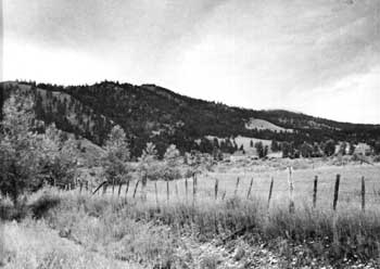
| Corner of the intermountain valley known today as Ross's Hole. At this place, the explorers encountered some Flathead Indians and obtained from them a number of badly needed horses. (National Park Service (Mattison, 1958).) |
The shape of the hill- and mountain-enclosed valley resembles a Christmas tree, whose base is at the south, where the valley is about 4 miles wide. It extends northward about 8 miles, gradually tapering to a point. Except for the small community of Sula, a few ranch-houses, and highway U.S. 93, which skirts the southwestern corner of the hole, where Lewis and Clark met the Flatheads, modern intrusions in the cove are negligible. Various unimproved roads provide access to the northern part of the valley. Between Salmon, Idaho, and Lolo, Mont., U.S. 93 closely follows most of the Lewis and Clark route.
 |
http://www.cr.nps.gov/history/online_books/lewisandclark/site26.htm
Last Updated: 22-Feb-2004