PU'UHONUA O HONAUNAU NHP
A Cultural History of Three Traditional Hawaiian Sites
on the West Coast of Hawai'i Island

|
PU'UKOHOLA HEIAU NHS • KALOKO-HONOKOHAU NHP • PU'UHONUA O HONAUNAU NHP A Cultural History of Three Traditional Hawaiian Sites on the West Coast of Hawai'i Island |
|
|
Site Histories, Resource Descriptions, and Management Recommendations |
CHAPTER IX:
PU'UHONUA O HONAUNAU NATIONAL HISTORICAL PARK (continued)
F. Description of Resources: Central Keokea Ahupua'a (continued)
6. Alahaka Heiau
The best known heiau within the park are the four located in the pu'uhonua enclosure: the "Old Heiau, 'Ale'ale'a Heiau, Hale-o-Keawe, and Hale-o-Papa, all of which have been investigated archeologically.
Two other heiau exist in Keokea ahupua'a that are very important although little studied — Oma'o Heiau, previously described, and Alahaka Heiau (Map 5). In 1985 NPS Pacific Archeologist Gary F. Somers and Cartographer M. Melia Lane cleared vegetation from the structures and mapped them. Stabilization work on Alahaka consisted of rechinking the wall and stabilizing the loose rubble at the base of the breaks to prevent slumping.
During his 1930 survey of Hawaiian structures along the west coast of Hawai'i Island, John Reinecke found at Alahaka a platform measuring about 95 by 60 feet surrounded by vertical walls from 5 to 7-1/2 feet high. No individual platforms or other divisions could be seen on the surface. Reinecke surmised that many of the platform stones had been taken to construct a large goat pen that stood 110 feet northwest of the platform. In terms of construction techniques, Reinecke observed that
The lava in this neighborhood is of columnar basalt and the vertical walls have been built by laying the columns on their side, with the original fracture outward.... Thinner columns were used in the form of bridgework and hanging pavements to fill the interior of the platform. . . . For the completion of the floor or hanging pavement, it may be said that other horizontal columns were laid side to side at right angles to and flush with the horizontal stones resting on the uprights. The finish was then added, in the form of small stones which filled in the cracks and covered the stone beams to the depth of 3 or 4 inches. [220]
Reinecke was given the name Heiau Walahaka for this structure. [221] Emory, working in the park in 1957, noted that
Lying within the amphitheater formed by the cliffs of Alahaka is the stone platform of an ancient heiau, 60 by 90 ft, and at its highest point above the surrounding lava floor, 8 ft high. It is remarkable for its facing of carefully fitted lava stones with a flat, vitreous surface exposed in the face of the wall, and for its pao (vaulted) construction. All through the greater part of the platform, glimpses into the hollow underpinning may be had, where the pavement has been torn up perhaps by curiosity seekers, perhaps for stones to build the goat pen 150 ft northwest. The southern end was lower, and distinct divisions in the pavement were originally present. [222]
Stokes was told in 1906 that this was not a heiau and therefore only looked at it from a distance; in 1919, however, an elderly former resident of the Keokea beach area stated that it had functioned as a Hale o Lono, an agricultural temple, not requiring human sacrifices. [223] Henry Kekahuna found the name 'I-maka-koloa, that of a famous Hawaiian chief, associated with the structure. [224]
Emory believed that Alahaka was probably contemporaneous with 'Ale'ale'a because both had the same pao type of construction. [225] If this similarity in construction indicates a contemporary time period, then Alahaka may date from ca. A.D. 1500. 'Ale'ale'a Ill and IV, attributed by Barrère to 'Umi, who dates from that time period, illustrate pao construction also. [226]
This heiau has good interpretive potential because it has more integrity than many of the structures in the park that have been restored or reconstructed or that are in complete ruin. Its good state of preservation and easy access via the 1871 trail make it a good place to interpret heiau construction and classifications.
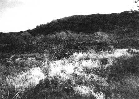 |
| Illustration 193. Alahaka Heiau remains. NPS photo, 1989. |
 |
|
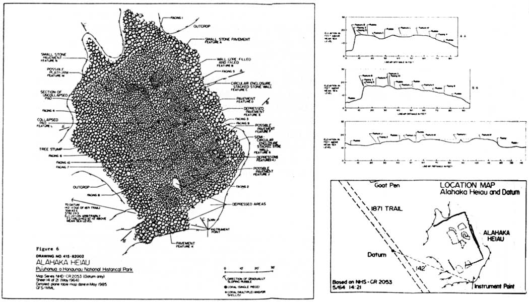
Illustration 194. Ground plan of Alahaka Heiau. Figure 6
in Somers, Mapping and Stabilization of Alahaka and Oma'o Heiau,
p. 8. (click on image for an enlargement in a new window) |
7. House Platform at Base of Alahaka Ramp
Still visible today are the remains of an ancient house platform that Emory noted (Map 5) where the 1871 trail turns to mount the ramp up the cliffside. The ruins comprise one platform on top of a larger one. Reportedly the person living there served as a guard (for the burials?) or possibly as a tollkeeper for the road or was the one who helped travelers ascend the ladder to the top of the cliff.
8. Fisherman's Shrine
A fisherman's shrine once stood at the edge of the cliff overlooking the sea on Pukakio Point. Originally there was a pair of gods here, but both have been stolen. The last one taken was a 2-1/2-foot-high carving of natural stone with a human face. Only the hole for the stone remains.
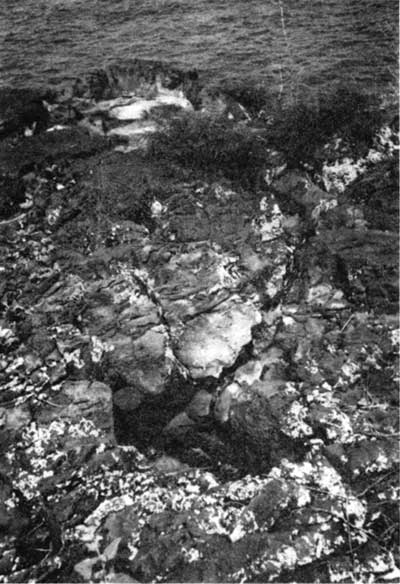 |
| Illustration 195. Site of fishermen's shrine on the edge of the cliff at Pukakio Point. Only a hole in the rocks remains. NPS photo, 1989. |
| <<< Previous | <<< Contents >>> | Next >>> |