PU'UHONUA O HONAUNAU NHP
A Cultural History of Three Traditional Hawaiian Sites
on the West Coast of Hawai'i Island

|
PU'UKOHOLA HEIAU NHS • KALOKO-HONOKOHAU NHP • PU'UHONUA O HONAUNAU NHP A Cultural History of Three Traditional Hawaiian Sites on the West Coast of Hawai'i Island |
|
|
Site Histories, Resource Descriptions, and Management Recommendations |
CHAPTER IX:
PU'UHONUA O HONAUNAU NATIONAL HISTORICAL PARK (continued)
E. Pu'uhonua o Honaunau (continued)
4. Early Study, Restoration, and Archeological Efforts
The first effort to preserve features of the pu'uhonua began after the Bishop Estate acquired the property in the late 1880s. S. M. Damon leased the property from the estate and financed restoration work on the primary structures, severely damaged by tidal waves or high surf, in 1902. Surveyor Walter A. Wall supervised these attempts to repair and restore the 'Ale'ale'a and Akahipapa heiau and parts of the Great Wall. [59] Other than drawing a plan of the refuge, Wall did not professionally document the nature or extent of his work. Comparison of photos of the Great Wall before and after 1902 show little difference in its appearance, indicating only minor repairs at that time.
In 1919 Horace Albright, then Field Assistant to the Director of the NPS, visited the pu'uhonua and instantly recognized its archeological, historical, and cultural values. He suggested it should be a national monument, preserved just as were cliff dwellings and other cultural sites because of its interest and educational benefits. [60]
Also in 1919 John F.G. Stokes, then curator of Polynesian Ethnology at the Bishop Museum, undertook the first formal archeological fieldwork at the site by investigating the ruins and attempting further repair and restoration of the pu'uhonua and the Hale-o-Keawe. He mapped the complex and carried out excavations and restoration of several structures, concentrating on the Hale-o-Keawe, the Great Wall, and the sandy beach within the pu'uhonua, and also digging some exploratory trenches in the mound of the "Old Heiau. [61] He found human burials common in the beach sand inside the refuge and lust outside the southern arm of the Great Wall. In the course of that work, Stokes conducted many on-site interviews with local Hawaiians, finding that even by that time, reliable information on the area prior to the overthrow of the kapu system was scant. [62] He restored the Hale-o-Keawe stone platform and repaired walls. The county of Hawai'i finally leased the site as a park to preserve the area pending further action affording the site national recognition. In 1949 several officials of the NPS, including Regional Historian V. Aubrey Neasham, completed a comprehensive historical survey and analysis of the City of Refuge, also recommending its recognition as a national monument or a national historic site to preserve and interpret it for future generations. [63]
In 1952 Henry P. Kekahuna and Theodore Kelsey began a project to locate, examine, and record the historic sites in Honaunau, Keokea, and Ki'ilae from the seashore to 2,500 feet upland. This involved recording all features of legendary and historical interest, sketching archeological remains, and preparing an account of their findings. In the course of that project they studied materials in the Bishop Museum, interviewed elderly residents of the Honaunau area, compiled a descriptive map of the pu'uhonua, and wrote a series of articles in the Hilo Tribune Herald describing features in the refuge and its vicinity. In 1956 Kekahuna compiled an interpretive map of the Ki'ilae ruins. This effort succeeded in furthering the movement for establishment of a national park.
In 1956 Stokes came out of retirement to help the Bishop Museum Department of Anthropology produce a major two-volume report, The Natural and Cultural History of Honaunau, Kona, Hawaii, which it prepared for the NPS and which contains the heretofore unpublished work of Stokes as well as ethnohistoric studies by Dorothy Barrère and Marion Kelly. Dr. Kenneth P. Emory supervised the surveying, inventorying, and mapping of resources and the collecting of traditional and historical data on the City of Refuge and its surrounding area. His contributions are also included in the report. This document, the basic data source for the park, was reproduced in one volume in 1986.
After establishment of the national park, the NPS began a long-range restoration program, including additional research. It initially contracted with the Bishop Museum in 1962 and 1963 to conduct further archeological excavations at the new park. This work was intended to build upon that accomplished by Bryan and Emory in 1957 on the area's natural and cultural history. Although Robert N. Bowen briefly surveyed caves in the Keanae'e Cliff in 1957, Lloyd J. Soehren of the Bishop Museum began the first modern excavations at Honaunau in 1962 by conducting test excavations in two areas where the NPS planned construction of public facilities. The sites Soehren tested included an arc-shaped area around the base of pahoehoe flows inland from the 1871 trail, between the "Holua Honaunau and the north boundary of the park. Features there were threatened by planned construction of public and administrative facilities in the area inland of the pu'uhonua. The other area he surveyed was part of the coral sand dune extending from the southern end of the Great Wall nearly to the foot of Keanae'e Cliff at Alahaka. The portion tested was in Keokea at Pele'ula.
Park Archeologist Edmund Ladd followed this work with extensive tests between the park entrance road and some of Soehren's sites early in 1963 and also conducted other investigations that year in connection with stabilization efforts at the horse ramp in Keokea, at the Great Wall, and at 'Ale'ale'a Heiau. [64] Donald Tuohy also carried out excavations in 1963, along a proposed road right-of-way within the park boundaries leading from the park entrance toward Ki'ilae Village. This work included areas adjacent to the proposed roadway and others threatened with destruction both from natural causes and increased public use. [65]
Since 1961 the NPS has overseen stabilization and restoration of the Great Wall and the 1868 Alahaka ramp, restoration of the 'Ale'ale'a Heiau stone platform, restoration of the Hale-o-Keawe platform and reconstruction of its temple images. [66] A base map locating the Alahaka-Keanae'e ruins came out in 1963. Alahaka and Oma'o heiau have been cleared of vegetation, mapped in detail, and stabilized. Historian Frances Jackson completed a historical study of Ki'ilae Village in 1966, and archeological base maps completed in 1968 show the major walls and stone structures there. Test excavations were conducted at Site B-105 (holua sled track), B-107 (beach deposit), and B-108 ("Chief's House Complex") in 1968. In 1980 the "Old Heiau" was excavated.
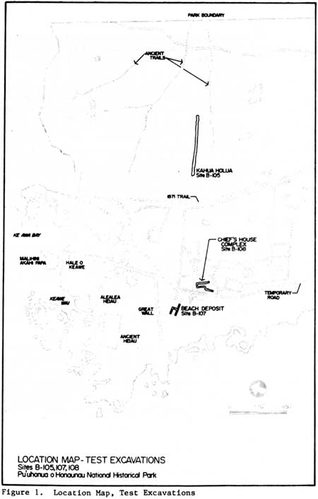 |
| Illustration 160. NPS test excavations, Pu'uhonua o Honaunau NHP, 1968. Figure 1 in Ladd, Test Excavations, p. 2. |
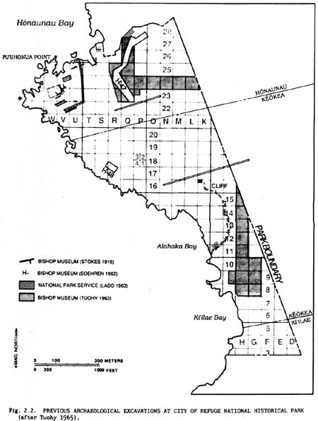 |
| Illustration 161. Archeological excavations at Pu'uhonua o Honaunau NHP, 1919-63. Figure 2.2 in Tuohy, "Salvage Excavations at City of Refuge," p. 75. |
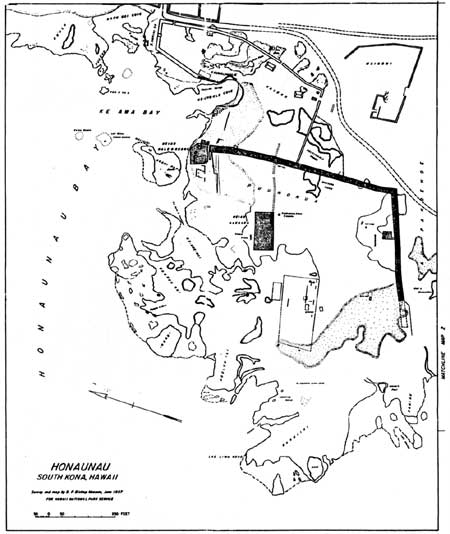 |
| Illustration 162. Map 1, "Honaunau," showing pu'uhonua area and associated features. Survey and map by Bishop Museum, 1957. From Emory, "Hinterland and Keamoali'i." |
| <<< Previous | <<< Contents >>> | Next >>> |