PU'UHONUA O HONAUNAU NHP
A Cultural History of Three Traditional Hawaiian Sites
on the West Coast of Hawai'i Island

|
PU'UKOHOLA HEIAU NHS • KALOKO-HONOKOHAU NHP • PU'UHONUA O HONAUNAU NHP A Cultural History of Three Traditional Hawaiian Sites on the West Coast of Hawai'i Island |
|
|
Site Histories, Resource Descriptions, and Management Recommendations |
CHAPTER VIII:
KALOKO-HONOKOHAU NATIONAL HISTORICAL PARK (continued)
G. Description of Resources (continued)
3. Graves
The significance of grave sites scattered throughout the Kaloko-Honokohau area was discussed earlier. Grave features in the park consist of burial cists, graves bordered with stones, pit burials, burials in natural depressions in the pahoehoe, platform tombs, and graveyards and cemeteries. To disturb such sites would be a great sacrilege.
4. Trail Systems
Historian Russell Apple describes four major types of Hawaiian trails: Type A are single-file prehistoric paths; Type B came into use after European contact and the introduction of horses. They were a modification of Type A trails, with curbstones and causeways; Type C were two horse wide and built in straight lines between major points, cutting off the small coastal settlements. The Mamalahoa Trail, a straight, curbed, cut-and-fill path, is a good example of this type. They were commonly built by labor forces conscripted by the island governors during the mid-nineteenth century. With the introduction of wheeled vehicles, Type C trails were modified, widened, and realigned into Type D trails. [74]
In prehistoric as well as historic times, trail networks were important adjuncts to the Hawaiian social and economic systems. They served both as major routes between specific land units and social groups and as internal networks of lesser trails for transportation and communication within an ahupua'a. The earliest trails were designed only for foot traffic because the people had no draft animals or wheeled vehicles. They were not particularly smooth, flat, or easy to follow. Sometimes they meandered, based on the availability of rocks for marking the route. Residents of an ahupua'a built trails running mauka-makal as soon as they settled into an area to facilitate food gathering and goods exchange. These goods were transported by sling nets or carrying poles.
Major commercial trails between ahupua'a, villages, and towns running on the contour of the island along the coast were a necessity and were quickly incorporated into the overall trail system. Other major routes were built over the mountain ranges to connect communities on opposite sides of the island. One very important trail, the King's Highway, borders the Kona Coast and is still visible from the Queen Ka'ahumanu Highway between Kawaihae and Kailua. It was used for commerce, troop movements, carrying messages, collecting taxes, and other government activities. It was considered very safe for travel, being specifically under the auspices of King Kamehameha I's "law of the splintered paddle," which directed that any traveler could use the highway without fear of being molested. [75] It led from Kawaihae to Kiholo, upslope to Huehue, and down again to Kaloko, Honokohau, Kealakehe, and Kailua. [76]
The trails of Kekaha reflect various stages in the development of the region, as relations were established between coastal and inland villages and between coastal settlements. Several examples exist within this park of the most ancient footpaths of the area, comprised either of steppingstones of smooth waterworn cobbles brought from the seashore and placed three to four feet apart or of flat lava slabs laid over the rough a'a flows. White coral pebbles that reflected moonlight marked some paths for night travel. Other paths across a'a flows consisted of simple, worn, trough-like depressions formed by feet crushing clinkers into a pebble-sized bed. In some places these trails were modified in historic times for animal travel and thus some of their earliest integrity lost. Where no old foot trails existed to be modified, new horse trails were built in historic times, mainly for commercial purposes. [77]
In Kaloko-Honokohau the residents built a system of mauka-makai trails to travel and communicate with extended family members and friends. Other routes traversed the coast laterally to transport food and other goods to neighboring ahupua'a. Several trails are found in the Kaloko-Honokohau area, mostly short footpaths comprising a local trail system, used both in the prehistoric and early historic (pre-1840) periods. Some prehistoric trails modified with curbs have been identified here, as well as new, probably post-1840, straight curbed trails. [78] Although a mauka -makai exchange system was used for many products, the produce of Kaloko and the other fishponds would not have been available for exchange and use by commoners. The public Mamalahoa Trail and the ancient coastal trail were two major routes around the island, leading south to Kailua-Kona and north to Keahole. In early times the coastal trail would have facilitated transportation of fish from this area to Kamakahonu — Kamehameha's court and primary political and economic center in Kailua — which probably consumed most of the products from the ponds in the area. The coastal trail ran right by 'Ai'opio Fishtrap. [79]
These trails are an important component of the park's cultural landscape, providing data on the linkages between communities. They comprise a record of local movement and sometimes include associated features such as small cairns placed as markers along the routes or petroglyphs (especially where smooth lava is found) that serve as pictorial signatures of people who passed by. Often caves or small walled shelters are found that served as resting places along longer trails. The Mamalahoa Trail is one of the most significant resources in the park, but all the trails are important in illustrating early communication, transportation, and commercial networks. Their importance to the prehistoric Hawaiian subsistence economy cannot be overlooked, because they were the lifelines for food exchange. They were a direct result of the belief that everyone had access rights to the products of the land and ocean for their sustenance.
The early Hawaiian trail system made this type of utilization possible within the land unit. [80] Along the leeward coasts these trails can still be seen and indeed many are still used today by fishermen and campers.
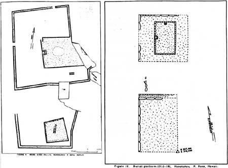 |
| Illustration 123. Examples of two types of features found in the Honokohau area. Figures 9 and 10 from Emory and Soehren, Archaeological and Historical Survey, Honokohau Area, pp. 22, 24. |
| <<< Previous | <<< Contents >>> | Next >>> |