|
Hubbell Trading Post
Cultural Landscape Report |

|
ANALYSIS AND EVALUATION (continued)
ANALYSIS OF LANDSCAPE CHARACTERISTICS
An evaluation of the landscape associated with the Hubbell trading post was conducted by examining the eleven characteristics of the cultural landscape (spatial organization, cluster arrangement, circulation, vegetation, land use, response to natural features, cultural traditions, structures, views and vistas, archeological resources, and small scale elements), identifying both historic and existing character-defining features, and determining the integrity of the resource using National Register criteria.
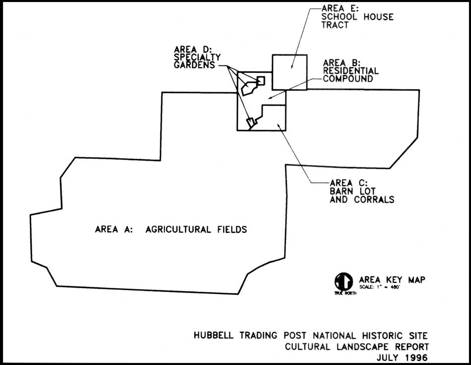
This study has examined approximately 160 acres. For the purpose of analysis and discussion the land was divided into seven definable historic land use areas. These areas include the agricultural fields and associated irrigation ditches; the residential compound; the barn lot and corral area (figure 83); the specialty garden areas (vegetable garden/flower garden); the school house/chapter house tract; Hubbell Hill outside of current park boundary; and the irrigation reservoir, main canal, and Ganado Lake and Dam all of which are outside of current park boundary (figure 84).
Each of the seven areas are discussed below with regard to their distinct historic character and specific assemblages of features that contribute to the area's significance. The discussion also covers the area's land use history as identified through research endeavors, existing conditions, and sensitivity to change. Character defining features are documented in Table 2.
|
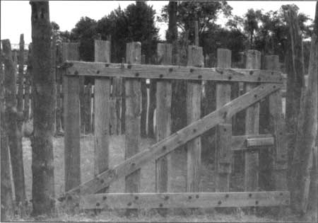
| Figure 83. Gate in barn lot area adjacent to sheep pens, 1993. |
|
| Figure 84. Historic land use areas as defined by landscape analysis. (click on image for a enlargement in a new window) |
Table 2. Character Defining Features
| CHARACTERISTIC | FEATURE | CONTRIBUTES |
| Circulation | entry road | yes |
| field service roads | yes | |
| woodplank bridge | yes | |
| two track dirt lane | yes | |
| Dorothy Drive (into park housing_area) | no | |
| road to maintenance area | no | |
| parking area-adjacent to visitor center/admin. offices | no | |
| stiles (wooden) | yes | |
| stiles (metal) | no | |
| fruit trees along irrigation_laterals elm trees along irrigation laterals |
yes | |
| yes | ||
| cottonwood trees along field edges | yes | |
| apricot tree in courtyard | yes | |
| walnut trees in field | yes | |
| elm trees on school house tract | yes | |
| bitterberry & chokeberry in yard | yes | |
| historic shrubs-lilac, yucca, rose, etc. | yes | |
| historic vines-silver lace, VA creeper, grape, etc. | yes | |
| perennials-iris, etc. | yes | |
| Structures | Trading Post HB-l | yes |
| Hubbell Home HB-2 | yes | |
| Barn HB-3 | yes | |
| Manager's Residence HB-4 |
yes | |
| Stone Bunkhouse HB-5 | yes | |
| Guest Hogan HB-6 | yes | |
| Bread Oven HB-7 | yes | |
| Utility/Chicken House HB-8 | yes | |
| Wareroom Extension HB-9 |
yes | |
| Corrals and Sheds HB-10 | yes | |
| Hogan in Lane HB-l I | yes | |
| School/Chapter House HB-12 | yes | |
| Pumphouse - Restroom HB-13 |
yes | |
| Rootcellar/Library HB-16 | es | |
| Gazebo S-02 | yes | |
| Fire Hose Houses | no | |
| Stone Planter s-04 | yes | |
| Rock Wall (around yard) S-05 |
yes | |
| Rock Retaining Wall on School House Tract | yes | |
| Matanzas | yes | |
| Sewage Lagoon | yes | |
| Irrigation Reservoir | yes | |
| Brick BBQ | yes | |
| Irrigation Laterals & Headgates HB-19 | yes | |
| Wagon Wheel Light Fixture | yes | |
| Stone Picnic Tables/Benches | yes | |
| Small Scale Features | Stone Bird Bath | yes |
| Sundial | yes | |
| Stone Benches (trading post) | yes | |
| Wagon Wheels (trading post) | yes | |
| Plaster bas relief plaque (trading post) | yes | |
| Grinding Wheel | yes | |
| Skull over entry (trading post) | yes | |
| Ornamental Petrified Wood & Mineral Specimens | yes | |
| Ladder with Dinner Bell | yes | |
| Farm Equipment (barn lots & Sheds) | yes | |
| Wagons | yes | |
| Feed/Water Troughs | yes | |
| Gate - Iron JLH (to yard area) | yes | |
| Gate - Iron Rod (Barn) | yes | |
| Gates - Misc. Wood | yes | |
| Gates - Misc. Metal | yes | |
| Gate - Corral | yes | |
| Boneyard | yes |
Spatial Organization and Patterns of Land Use
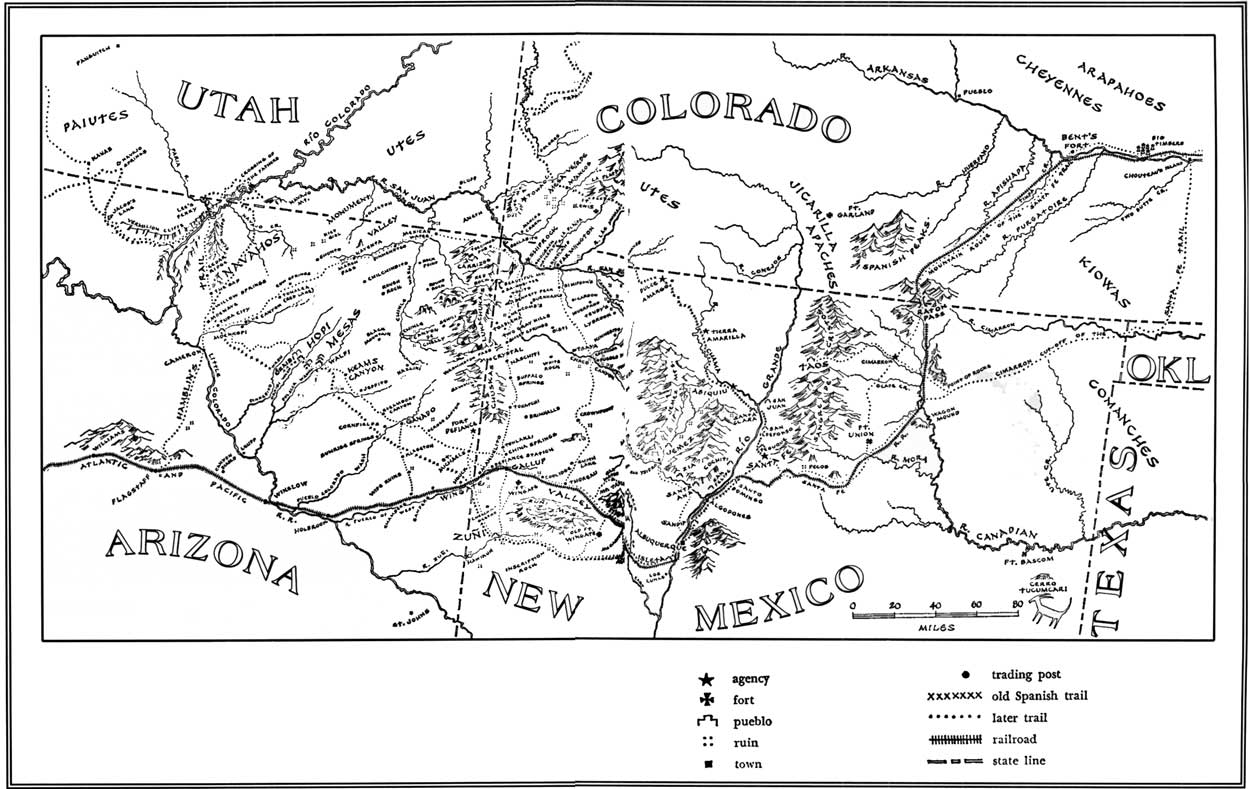
On a very large regional scale, one might look at the spatial arrangement of trading posts located within and immediately adjacent to the Navajo Reservation (figure 85). According to Adams, trading posts on the Navajo Reservation were often located approximately 20 miles apart to best serve the community and avoid undue competition between the posts. [132] One might also examine the Hubbell trading post with regard to its spatial arrangement in the context of other Hubbell family operations which included numerous trading posts, wholesale facilities, and other miscellaneous business ventures within and immediately surrounding the Navajo Reservation. A cursory examination of these relationships was made using readily available historical documentation as the majority of the region's trading posts and associated Hubbell family businesses are no longer existing. A thorough analysis of these relationships would be an excellent subject for an academic research project as would a thorough comparison of the Hubbell trading post with other posts located on the reservation. Again, a review of previous trading post studies was made in an effort to understand the overall context of the Hubbell trading post operation within the Navajo reservation but the primary focus of this study was limited to the Hubbell landscape. While some design characteristics found at Hubbell's Ganado post are highly characteristic of other posts on the reservation, the extensive agricultural operation is fairly unique. Some of the typical design characteristics are described in a later section of this report under Assessment of Resource Integrity.
Historically, the Hubbell landscape was comprised of approximately seven areas that reflect patterns of land use by the Hubbell family. These are the areas in which the Hubbells and their neighbors and associates lived, worked, and played. These areas included the agricultural fields of which there are five, and their associated irrigation features; the trading post and residential compound that includes the guest hogan, the manager's residence, the bread ovens, the chicken coop and the yard area that ties them all together; the barn lot, sheds, and corrals; the small specialty garden areas which include both the vegetable and flower garden plots; the school house/chapter house tract that now serves as the park's visitor center; the area known as Hubbell Hill is outside the park boundary; and the reservoir and associated irrigation system including the main canal and Ganado dam, all located outside of the park boundary.
The acreages of the six terraced agricultural fields are described by Peterson and included a total of about 110 acres. The easternmost field included 13 acres and was irrigated by a lateral feeding directly off of the main canal and following the western edge of the field that is also defined by a deep arroyo. This field is now occupied by the park's housing and maintenance areas. The second field is located east of the trading post and directly north of the Hubbell reservoir or holding pond and consisted of 16 acres. The field was irrigated using a lateral that fed off of the reservoir and followed the eastern edge of the field along the arroyo. The largest field area is located across the lane that leads south from the trading post and covers approximately 80 acres to the south and west of the trading post complex. This field was served by four laterals which according to Peterson were at some time or other served at least in part by the Hubbell's reservoir. [133] The first lateral runs along the eastern edge of the field and is connected to both the reservoir and the main canal. This lateral runs in a north-south direction towards the corrals and sheds and then veers west around the developed area and runs in a northwest direction towards the Pueblo Colorado Wash. The second lateral also runs in a north-south direction towards the Pueblo Colorado Wash and is fed primarily by a meandering ditch leading from the reservoir. Peterson notes that the 1931 Indian Irrigation Service map reveals that the third lateral which is now marked by a row of elm trees was served by the main canal as the Hubbell's constructed a supplementary ditch across a neighboring farm in an effort to maintain grade and bring water to the high ground along the farm's west side. [134] This lateral runs in a northwest-southeast direction. The fourth lateral was difficult to locate in the field as a result of years of wind blown sand and natural vegetation succession. The deteriorated condition of this lateral as well as barely discernible terraces reveal that over the years the family likely abandoned their attempts to keep water on the high fields of the southwest corner. [135]
Another small field area has been identified immediately west of the stone bunkhouse. This area does not appear to have been terraced but does include a small lateral irrigation ditch that runs along its eastern edge as well as a few small stone and wood headgates. The area was also enclosed by post and wire fencing along all sides. Oral histories have identified this field and noted that it was used historically by the family for the cultivation of corn. This field encompasses approximately a quarter acre of land.
Noticeable changes have occurred within two of the six terraced fields. The easternmost field has been converted into the park's housing and maintenance areas and has subsequently experienced the loss of its terraces and irrigation features. The field to the immediate west of the housing area has also been modified with regard to its overall acreage. Although historically cultivated by the Hubbells, the southern portion of this field is not within the homestead boundaries and is therefore not included within the park's boundaries. This southern area comprises approximately 5 acres. However, it should be noted that the area continues to be utilized for cultivation and provides visual continuity as a single large field from the entrance road south to the Hubbell Reservoir.
|
| Figure 85. Navajo, Hopi, and Zuni lands; adapted from McNitt (1962). Note locations and distribution of trading posts. (click on image for a enlargement in a new window) |
In 1964 there was an addition of a sewage lagoon covering approximately 1.5 acres in the north end of the big field located to the west of the corrals thereby reducing that field by a few acres. With this exception, the major changes to the westernmost fields consist of the disrepair of the historic terraces and their lack of use for cultivation activities. In general these fields have retained their approximate acreages and overall organization.
With the exception of the loss of a few structures and features the trading post and residential compound area has retained its overall spatial organization and layout as has the barn lot and corral area. One of the three specialty garden areas has retained its historical configuration while the other two have been modified over the past several years. The small vegetable garden plot located immediately south of the stone bunkhouse is intact although it is rapidly succeeding with invasive vegetation while the flower garden that historically covered the majority of the residential yard area is no longer evident with the exception of a large mass of lilacs and the border beds that follow the inside perimeter of the stone wall. The vegetable garden area located immediately south of the guest hogan has been modified with regard to its acreage and has recently lost the historical patterning of its terraces.
The spatial organization associated with the areas located outside of the park's boundaries has remained fairly constant through time. The Ganado dam was raised from 22 to 25' in height so there has been some increase in the overall size of the reservoir — it will now hold 2800 acre feet of water. No changes have occurred with regard to the layout or configuration of the main canal system, the Hubbell Reservoir, or Hubbell Hill.
There has been no substantial loss in any of the spatial elements that comprise the Hubbell Trading Post landscape although the land use activities within some of the areas have changed over time. The entire homestead acreage is in the ownership of the National Park Service and the other contiguous areas remain in the ownership of the Navajo Nation. Despite the changes that have occurred with regard to land management and use, the spatial organization of the property has retained its integrity of location, design, setting, feeling and association.
| <<< Previous | <<< Contents >>> | Next >>> |
hutr/clr/clr5a.htm
Last Updated: 26-Apr-2004