
|
Washington Department of Natural Resources Geology and Earth Resources Division Bulletin No. 66 Geology of the Washington Coast between Point Grenville and the Hoh River |
PART I
Rock Formations and Their Geologic History
LATE CENOZOIC DEPOSITS
GENERAL DESCRIPTION
In almost all sea cliffs along the coast between Point Grenville and the Hoh River, nearly horizontal to gently dipping beds of semiconsolidated silt, sand, and gravel cover the underlying bedrock. In places the entire cliff is composed of these materials and may be more than 100 feet thick (figs. 22 and 55). Most, if not all, of these deposits probably were laid down during the last million and a half years or so—a period of time known to geologists as the Pleistocene Epoch (fig. 2).
A number of geologic events are rather well preserved in these relatively young deposits of silt, sand, and gravel. Preliminary studies of these as well as nearby deposits have made it possible to conclude various probabilities and even some facts about the local Pleistocene geologic history.
All materials contained in these deposits very likely were derived from bedrock outcrops of the Olympic Mountains. A large majority of the stones in the gravels are composed of graywacke sandstone. Individual pebbles contain abundant black siltstone chips set in a matrix of lighter colored sand grains, a lithology characteristic of many of the graywacke sandstone beds of Hoh rocks (fig. 21). Not more than 15 percent of the stones in these gravels are composed of other rock types, most of which are volcanic in origin and are much like those at outcrops in the Point Grenville area (see section on volcanic rocks of middle Eocene age). The few remaining stones are red argillites, phyllites, and cherts from the Olympic Mountains. Most of the sand and gravel was transported by streams and rivers and is known as "fluvial" deposits. In a few places some of the older materials may have been deposited directly by glaciers. Such materials are called "till." In other places fine-grained deposits that contain large amounts of carbonized plant material were deposited in shallow lakes. These "lacustrine" deposits are well exposed in the low beach cliffs immediately north of Kalaloch (fig. 57).
|
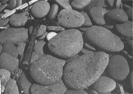
| GRAYWACKE SANDSTONE BEACH PEBBLES, common on many of the local beaches, contain many fragments of various rock types. Note the conspicuous black, angular shale fragments in some of the pebbles. Their disc-shape is typical of beach pebbles. (Fig. 21) |
|
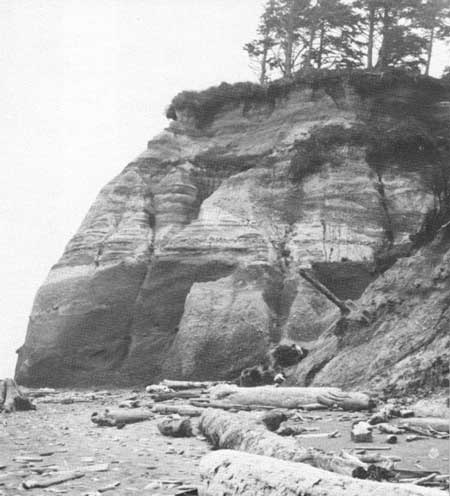
| TWO MAJOR SAND AND GRAVEL UNITS exposed in a sea cliff just south of Whale Creek. All materials were carved from the Olympic Mountains and transported to the coastal area by glaciers and streams from the glaciers during two different periods of time in the Pleistocene Epoch. The upper unit was probably deposited between 17 and 70 thousand or more years ago, whereas the lower unit was deposited prior to 70,000 years ago. The nearly horizontal contact separating the two units represents the trace of a now elevated wave-cut surface that was formed essentially at sea level, prior to the deposition of the overlying younger sand and gravel unit. (Fig. 22) |
The Pleistocene Epoch is commonly known as the "ice age." During this period of time, large areas of western Washington were glaciated on several occasions when average summer temperatures were about 10° F. colder than today. Periods of glaciation were separated by interglacial times when the climate was probably similar to that of today. Although major lobes of large ice sheets from Canada moved southward several times and covered much of the northern part of the Olympic Peninsula and the Puget Sound Lowland, only local alpine glaciers originating in the Olympic Mountains occupied the southwestern part of the Olympic Peninsula. The "Olympic" origin of these glaciers is shown by the kinds of rock debris laid down by the glaciers and the streams from the melting glaciers. Geologists have thus far concluded that the Olympic Mountains were occupied by glaciers at least four times. One or more of the older glaciers probably extended westward at least to our present-day coastline, particularly in the Hoh Valley area. However, the westward extent of the younger glacier was not as great. Even so, one of the last of the glaciers extended from the slopes of the Olympic Mountains westward to a point some 10 miles northeast of the Taholah-Point Grenville area, between 15,000 and 20,000 years ago.
|
| RED BEACH SANDS occur on many beaches along the coast. The color is caused by a concentration of small, 12-sided crystals of the mineral garnet. Because this mineral is relatively heavy, it, together with other heavy minerals, particularly the black magnetic mineral magnetite, tends to become concentrated by wave action as shown here near Hogsback. (Fig. 23) |
|
| TUNNEL ISLAND, off the mouth of the Raft River, is a relatively hard body of sand stone of the Quinault Formation. (Fig. 24) |
ORIGIN OF SAND AND GRAVEL DEPOSITS
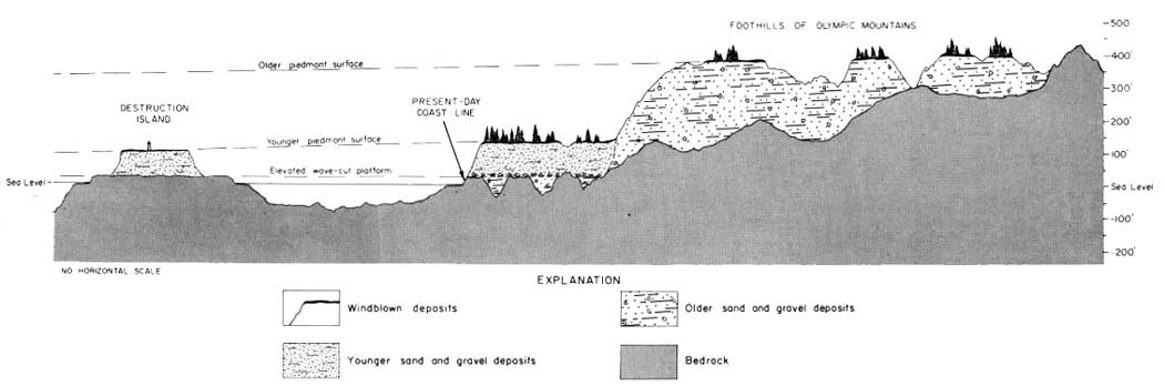
Most of the nearly horizontal semiconsolidated silt, sand, and gravel, visible in the cliffs between Point Grenville and the Hoh River, is rock debris that was brought down major valleys by streams and deposited along the coastal area probably 17,000 to 70,000 or more years ago. The uppermost surface of these deposits forms the broad, very gently westward-sloping surface that is conspicuous today in many places along the coast (fig. 1). This surface is known as a "piedmont alluvial plain." When first formed, it extended several miles farther westward than it does today, but much of it has since been removed by wave erosion back to the present coastline. The nearly flat surface on Destruction Island is the westernmost remnant of this piedmont surface (fig. 54).
Two major units of the sand and gravel deposits can be recognized readily along the coast between Point Grenville and the Hoh River. Outcrops of the older unit are confined to basal parts of some of the cliffs and are well exposed in three major areas: between Trail 5 and a point about one-half mile north of Beach Trail 7; from about three-quarters of a mile north of Abbey Island to near the Hoh River; and from about one-half mile south to nearly one-half mile north of the mouth of Whale Creek.
In some places stratification suggests that the older of the two deposits is slightly tilted whereas the overlying younger deposits appear nearly horizontal. This evidence suggests that slight warping of the older beds, as well as all strata below, took place before the overlying younger materials were deposited.
|
| SEASTACKS of sandstone north of Tunnel Island. These outcrops together with the sandstone of Tunnel island and nearby cliffs north of the Raft River are all a lower part of the Quinault Formation. (Fig. 25) |
Ancient Wave-Cut Surface
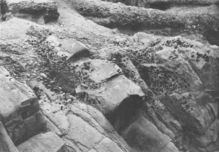
The contact between the two major sand and gravel units is frequently marked by a layer of cobbles and large boulders (fig. 63). Their occurrence indicates that the older beds were eroded and beveled by the sea to form a wave-cut platform upon which the residual cobbles and boulders were left prior to the deposition of the overlying beds (fig. 26).
|
| IDEALIZED CROSS SECTION showing relations between major Pleistocene deposits and the land surfaces that were formed by periods of either erosion or deposition during the Pleistocene Epoch. Older deposits were thick and extended many miles seaward. Erosion by wave action followed, removing much of these materials from the present-day Continental Shelf. A second and thinner series of sand and gravel was brought down major stream valleys and deposited on the now uplifted wave-cut platform. These younger deposits also extended seaward, but less so than the older deposits. They have been eroded by wave action back to the present-day coastline, leaving Destruction Island as a remnant of the mainland that existed farther west a few thousand years ago. Following the deposition of the younger sand and gravel deposits and probably before much vegetation had developed, windblown silt and sand covered much of the coastal area to a depth of as much as 4 feet. (Fig. 26) (click on image for an enlargement in a new window) |
This surface is now elevated in places, relative to present-day sea level. Because the older deposits were laid down on a somewhat irregular bedrock surface, largely formed on the Hoh and Quinault Formations, the wave-cut surface in places also bevels across bedrock high areas. Therefore, the erosion that formed the wave-cut platform has removed all of the older sand and gravel deposits above most of the bedrock ridges or high places, but the older sand and gravel deposits still remain in valleys or low areas that existed on the bedrock surface. Thus, in areas where the bedrock surface stood relatively high, such as between Point Grenville and Cape Elizabeth and at Browns Point, the youngest or uppermost sand and gravel unit now rests directly on bedrock with no intervening older beds of sand and gravel. Furthermore, because the bedrock formations had differing resistance to wave erosion, rounded knobs or stacks were left in places along the coast above the main level of the wave-cut platform, just as Willoughby Rock and Split Rock stand above the sea-level bench being formed along the coast today.
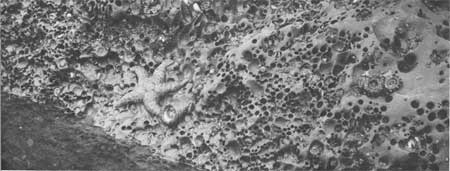
Possibly the most convincing evidence that this uplifted erosional platform was formed at sea level is the abundance of rock clam borings still well preserved in its surface (fig. 28). These borings were made by the piddock clams, pholadidea penita (Conrad), a form of clam found today only in tidal areas (fig. 27). Borings, usually about 1-1/2 inches in diameter, unmistakably of this origin, may be found in many places along the coast on this uplifted erosional platform at heights above today's sea level, varying from some 125 feet at Cape Elizabeth to just above high tide at the foot of Beach Trail 4.
|
| MODERN (PIDDOCK) CLAM BORINGS on the rock surface of a tide pool. Compare with fossil borings on uplifted tidal surface shown in figure 28. (Fig. 27) |
|
| FOSSIL (PIDDOCK) CLAM BORINGS preserved on an uplifted wave-cut surface of beveled sandstone strata exposed at the foot of Beach Trail 4—they were formed some 70,000 years ago during the Pleistocene Epoch. Compare with modern piddock borings common today in nearby tide pools, see figure 27. (Fig. 28) |
CRUSTAL WARPING AND CHANGES IN SEA LEVEL
The earth's crust continued to buckle and warp throughout the Pleistocene Epoch just as it did during older geologic times. However, the results have been relatively minor and are confined mostly to broad warping and minor uplifting. The older beds of sand and gravel in places have been noticeably affected, but warping is hardly perceptible in a single outcrop of the younger beds of sand and gravel. Nevertheless, they too have been broadly downwarped. The axis of the downwarp lies in the Kalaloch area, where the old wave-cut platform lies below sea level and the top of the younger sand and gravel deposits (essentially the land surface of today at Kalaloch) is only some 50 feet above sea level. However, a few miles both to the north and south these surfaces are both noticeably higher.
Much of the vertical movement of the earth's surface relative to sea level during the Pleistocene is believed to have occurred largely as a result of depression and rebound caused by the weight of great thicknesses of ice on the continent. However, the relative vertical movement is further complicated by the fall or rise in sea level caused by the formation or melting of the extensive continental ice sheets of the Pleistocene Epoch. The present-day elevated wave-cut platform separating the two sand and gravel units is one conspicuous example of sea level having been at a different relative position than it is today.
SUMMARY OF LATE CENOZOIC GEOLOGIC HISTORY
A period of emergence accompanied by moderate folding and faulting followed the deposition of the Pliocene Quinault Formation in the Washington coastal area of today. The Quinault Formation, as well as older rocks, was elevated well above sea level of that time and eroded by streams. A topography with considerable relief developed on these bedrock formations. Probably during early Pleistocene time, sea level along the Washington coast was lower than today because bedrock valleys formed at that time are known to be lower in places than the present-day sea level. However, these old valleys are now partially filled to present-day sea level, or higher, with sand and gravel deposits (fig. 26). Before this deposition began, however, sea level rose slightly so that the lower parts of the bedrock valleys were drowned to form shallow bays in which estuarine or bay sediments were formed. This was followed by much thicker and more extensive deposition of silt, sand, and gravel that was carried by the glaciers and the streams from melting glaciers. These materials probably were deposited some time prior to 70,000 years ago and blanketed the entire coastal area.
Remnants of the upper, nearly flat surface of these deposits can be seen today on top of some of the nearby foothills, particularly in the Taholah-Queets area, at an elevation of approximately 400 feet. This surface formed a broad piedmont plain with a very gentle seaward slope. At that time the coastline was many miles farther west than it is today.
Gentle warping of the earth's crust followed, together with a rise of sea level to a height of possibly 50 feet above present-day sea level. Waves cut a bench at that higher level, which extends eastward beyond the coastline of today to the western edge of the foothills. This marine erosion cut across ridges of the old bedrock and removed much of the earlier sand and gravel deposits, leaving undisturbed only those in the lower part of the old bedrock valleys. Beach deposits of residual boulders and cobbles were left strewn on the wave-cut platform.
Sea level was lowered once again to a point probably below that of today, leaving the wave-cut bench appreciably above sea level of that time. Stream deposits measuring more than 100 feet in thickness, together with some lake sediments, were deposited on this surface. Most of these sediments were brought down main valleys by melt water from alpine glaciers in the Olympic Mountains, probably 17,000 to 70,000 or more years ago. The top of these deposits formed another broad gently westward-sloping surface, some 200 feet lower than the older one, in the valleys, and over the wave-cut surface to the west. Well-preserved remnants of this lower surface form the top of Destruction Island and the generally 100- to 200-foot land surface immediately adjacent to much of the present-day coastline. At the time this surface was first formed, the coastline extended a number of miles farther to the west than it does today. Finally, fine-grained silt and clay, believed to have been carried and deposited by the wind, less than 17,000 years ago, blanketed all existing surfaces to a thickness of three or four feet. These materials form the yellow-colored sediments that are exposed today in the uppermost few feet of many of the cliffs along the coast.
Since the younger surface was formed, the sea has again eroded eastward a number of miles and formed another wave-cut bench essentially at present-day sea level. Thus, the coastline of today is, in places, as much as 200 feet below remnants of the youngest Pleistocene piedmont surface.
Very broad warping of the earth's crust has continued. Locally it has lowered the younger piedmont surface to within 50 feet of sea level near Kalaloch and elevated other areas to the north and south at least 150 feet above sea level. (Suggested technical reading about the Pleistocene in this and nearby areas: Baldwin, 1939; Crandell, 1964, 1965; Florer, 1972; Heusser, 1972; Moore, 1965.)
| <<< Previous | <<< Contents >>> | Next >>> |
state/wa/1973-66/sec1-4.htm
Last Updated: 28-Mar-2006