
|
Washington Department of Natural Resources Geology and Earth Resources Division Bulletin No. 66 Geology of the Washington Coast between Point Grenville and the Hoh River |
PART II
Geologic Observations and Interpretations Along Segments of the Coast
POINT GRENVILLE AREA
OLDER ROCKS
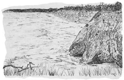
Point Grenville and the nearby sea stacks (fig. 1) are composed largely of volcanic rock, a material more resistant to erosion than most other rock formations along the coast. These rocks were formed many millions of years ago when hot magma was spewed onto an ocean floor from fractures in the earth's crust. The rapid cooling of the magma by sea water formed a highly fractured and glassylike igneous rock now poorly welded together with secondary minerals. These rocks are sometimes referred to as a "volcanic breccia." Some of the muds of the ocean floor were incorporated in the volcanic material and can now be seen, particularly on the southeast side of the point, as somewhat contorted and irregular beds of limy siltstone (fig. 31). Microscopic fossils from these siltstone beds indicate that they were deposited some 45 to 50 million years ago, in middle Eocene time (fig. 2). These fossils represent the oldest geologic record known in the rocks along the coast between this point and the Hoh River. Crustal movements have been nearly continuous, since the rocks of Point Grenville were formed, and therefore over the centuries they have become somewhat contorted. Today, these rocks are steeply tilted and form one of the major promontories along the Washington coast.
YOUNGER ROCK DEPOSITS
On top of the volcanic rock foundation of Point Grenville are deposits of nearly horizontal, poorly stratified, semiconsolidated sand and gravel. In places, they are at least 50 feet thick. These deposits are extensive in the coastal area and cover much of the older rock. They were deposited by the streams from glaciers that extended down the slopes of the Olympic Mountains during the Pleistocene Epoch, some 17 to 70 thousand or more years ago. Glaciers advanced several times into nearby areas, and during at least one advance they stood within some 5 miles of Point Grenville.
ANCIENT SEA LEVELS
The uppermost, present-day, nearly flat surface on Point Grenville (fig. 1) slopes imperceptibly seaward, and, when first formed, extended seaward to sea level probably a number of miles to the west. Since then, some 17,000 or more years ago, wave action has eroded the coast eastward to its present-day position, leaving a wave-cut platform at essentially sea level of today. Evidence of an earlier wave-cut platform some 50 feet higher can be seen at the contact between the older rocks and the overlying sand and gravel. Borings formed by piddock clams, known to live only in tidal areas are present on this uplifted bedrock surface at Point Grenville and many other places along the coast (fig. 28).
GRENVILLE BAY AREA
Eastward from Point Grenville, along Grenville Bay, bedrock is extensively broken and largely covered by landslide debris from overlying sand and gravel deposits. Those bedded sandstone and siltstone strata exposed for a few hundred yards immediately to the east of the main body of the Point Grenville volcanics are believed to have been deposited some 35 to 40 million years ago during late Eocene time (see Part I, Sedimentary rocks of late Eocene age). The remaining bedrock outcrops, consisting of conglomerates, sandstones, siltstones, and volcanic rocks, along the shore of Grenville Bay, are all tentatively referred to a much younger, although badly contorted, rock unit known as the Hoh rock assemblage (see Part I).
| <<< Previous | <<< Contents >>> | Next >>> |
state/wa/1973-66/sec2-1.htm
Last Updated: 28-Mar-2006