
|
Washington Department of Natural Resources Geology and Earth Resources Division Bulletin No. 66 Geology of the Washington Coast between Point Grenville and the Hoh River |
PART I
Rock Formations and Their Geologic History
THE QUINAULT FORMATION
GENERAL DESCRIPTION
Outcrops of the Quinault Formation, a series of sedimentary rocks largely of marine origin, are almost entirely confined to the Quinault Indian Reservation and are well exposed in many of the cliffs and on tidal benches between Point Grenville and the vicinity of the Raft River. The name Quinault (Quinaielt) was first applied to this group of rocks by Dr. Ralph Arnold, in 1906, in a published report on reconnaissance studies of the Olympic Peninsula. Although nowhere is the formation known to outcrop more than 3 miles inland, equivalent rocks are known in the subsurface of the Continental Shelf, extending at least 20 miles seaward and for a distance of at least 40 miles along the adjacent coast.
The limited onshore outcrop area of this formation is of particular interest to petroleum geologists because strata may be studied there that are otherwise essentially inaccessible on the adjacent Continental Shelf. Furthermore, the formation is generally regarded as one of the more favorable potential petroleum reservoirs off the Washington coast.
The Quinault Formation is varied in composition ranging from fine-grained rocks, such as massive siltstones, to coarse-grained beds of sandstone and conglomerate. Both megafossils, mostly of clams and snails, and microscopic fossils (Foraminifera) are abundant in places within the Quinault Formation. A few of the more commonly known species of megafossils have been identified by Dr. Warren O. Addicott of the U.S. Geological Survey and are listed below:
Gastropods:
Antiplanes perversa (Gabb)
Mediargo mediocris (Dall)
Nassarius andersoni (Weaver)
Nucella cf. N. lamellosa (Gmelin)
Trophonopsis sp.
Pelecypods:
Lituyapecten sp.
Lucinoma annulata (Reeve)
Securella sp.
Thyasira bisecta (Conrad)
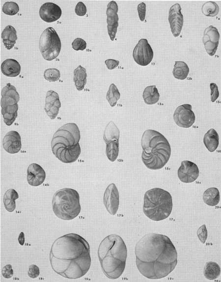
Some of the Foraminifera are shown and identified in figure 13. Details on the Foraminifera of the Quinault Formation are discussed in another report (Rau, 1970). Fossils from the Quinault Formation indicate a Pliocene age and therefore, as shown in figure 2, the Quinault Formation was deposited some 1.5 to 7 million years ago. These rocks are much younger than the Hoh rocks—the next oldest rock unit of the area. Figure 2 shows that no rocks are present to portray the considerable amount of geologic time between that of the middle part of the Miocene Epoch, represented by Hoh rocks, and the Pliocene Epoch, represented by the Quinault Formation. The local absence of rock strata to represent a period of geologic time that is known elsewhere is called an uncomformity. It indicates that the land was above the sea, and erosion rather than deposition was probably taking place during a latter part of the period of time not represented by rock formations. Additional rocks may have been deposited after the deposition of the Hoh rocks and prior to that of the Quinault Formation, but, if so, they were eroded away before the deposition of the Quinault Formation. Furthermore, much of the complicated folding and faulting (uplift and deformation) of the older Hoh rocks must have taken place during the time that is not represented by strata, because the younger Quinault Formation, although gently tilted and occasionally faulted, displays far less disturbance than do the Hoh rocks.
|
|
MICROSCOPIC FOSSILS "Foraminifera," from the
Quinault Formation. Fossils of this extremely varied organism are common
in the Quinault Formation as well as in most other sedimentary rocks of
marine origin. Conditions of deposition such as depth and the
temperature of the water in which they lived can be estimated from such
fossils. Furthermore, assemblages vary according to when they lived;
and, therefore, they are useful indicators of geologic time. All
specimens magnified about 25X and are identified below: 1. Bulimina subacuminata Cushman and R. E. Stewart 2. Globobulimina auriculata (Bailey) 3. Oolina melo d'Orbigny 4. Virgulina californiensis ticensis Cushman and Kleinpell 5. Bolivina advena Cushman 6. Bolivina acuminata Natland 7. Uvigerina cf. U. hootsi Rankin 8. Uvigerina juncea Cushman and Todd 9. Uvigerina senticosa Cushman 10. Uvigerina subperegrina Cushman and Kleinpell 11. Angulogerina semitrigona (Galloway and Wissler) 12. Oolina borealis Loeblich and Tappan 13. Discorbis? columbiensis Cushman 14. Valvulineria malagaensis Kleinpell 15. Valvulineria washingtonensis (Cushman and R. E. and K. C. Stewart) 16. Eponides healdi R. E. and K. C. Stewart 17. Buccella inusitata Andersen 18. Rotalia cf. R. Garveyensis Natland 19. Cassidulina californica Cushman and Hughes 20. Epistominella pacifica (Cushman) (Fig.13) |
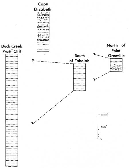
MAJOR SECTIONS OF CONTINUOUS STRATA
If those beds of the Quinault Formation exposed in the various outcrops along the coast were placed in their original, nearly horizontal position, the thickness would measure over 6,000 feet. Nowhere can the entire thickness of 6,000 feet be observed in one complete stratigraphic section, but major segments of the sequence can be seen in a tilted position in the four nearly continuous series of outcrops discussed below.
North of Point Grenville
The southernmost of these sections of strata is exposed in the nearly vertical cliffs that begin about one-quarter of a mile north of Point Grenville (fig. 29). From this point northward for nearly 1 mile, gently tilted beds, predominantly sandstone, are exposed in the nearly vertical cliffs beneath a cap of younger gravel (Frontispiece). These dipping beds are believed to represent a middle to upper part of the Quinault Formation (fig. 14).
|
| CORRELATIONS of four major sections of the Quinault Formation. (Fig.14) |
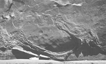
Numerous, well defined, and, in many places, very large features of sedimentation, together with structural patterns that were formed shortly after deposition, are well preserved in this section (Horn, 1969). Many scour and fill structures may be seen at several horizons (fig. 30). They represent the periodic erosion of channels by local currents in semiconsolidated sediments. Most channels have been filled subsequently with angular, coarse conglomerate and grit, together with numerous shell fragments. Many other sedimentary structures may be seen, including flamelike structures, pulled-apart bedding, and other types of contorted bedding (fig. 15). Both large and microscopic fossils are common. These fossils, together with the various types of sedimentary structures, indicate that sedimentation most likely took place in a deltaic environment off the mouth of a major stream. Furthermore, the fossils suggest that water temperature during deposition was probably cool to cold, similar to that off our coast today.
|
| CONTORTED BEDDING in the Quinault Formation exposed in the sea cliffs north of Point Grenville. When these beds were still unconsolidated, a thin silt layer was irregularly squeezed and contorted upward into an overlying massive sand body. Subsequent differential movement of the beds further contorted the silt layer. (Fig. 15) |
|
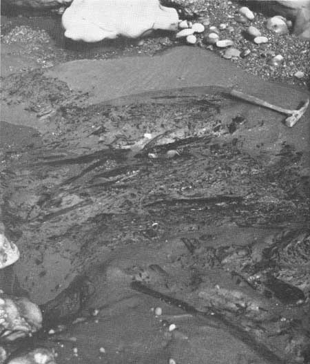
| CARBONIZED BRANCHES and other plant materials in massive sandstone of the Quinault Formation exposed on the beach near Cape Elizabeth. (Fig. 16) |
South of Taholah
Northward for about 1 mile, a partially gravel-covered landslide area separates the first section from a second, nearly continuous sequence of northward-dipping beds of the Quinault Formation. The second section extends about half a mile northward and ends some three-quarters of a mile south of Taholah (fig. 29). These strata are distinct from those of the first section in that they are largely massive to faintly bedded siltstone, a generally finer grained rock than the sandstone beds of the first section. Microfossils are common and varied, indicating that they could have been deposited about the same time as those of the first section. However, final deposition most likely took place in a noticeably deeper marine environment than is indicated by the fossils of the first section, probably well below the outer edge of a continental shelf at water depths between 900 to 2,000 feet. Some of the micro-organisms actually lived at much shallower depths, but their shells were redeposited along with other sediments at the greater depth, together with the remains of those that actually lived at this greater depth.
Cape Elizabeth
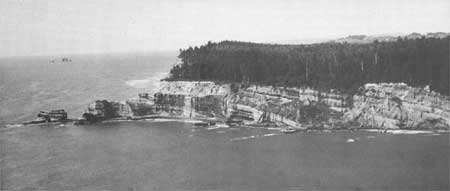
A third, nearly continuous sequence of the Quinault Formation is exposed in the Cape Elizabeth area (fig. 29). Gently, southeastward-dipping beds of conglomerate, sandstone, and some siltstone form the high cliffs and tidal benches, extending from a place about a quarter of a mile north of the mouth of the Quinault River to Cape Elizabeth (fig. 17). Similar outcrops continue northward to a place about 1-1/4 miles north of Cape Elizabeth where they suddenly end in sharp contact with outcrops of older, dark-colored, jumbled Hoh rocks. The sequence of beds at Cape Elizabeth and vicinity forms about 1,600 feet of tilted, nearly continuous strata of the Quinault Formation. These beds are believed to represent an uppermost part of the formation (fig. 14). The basal one-third of this section, visible in the northernmost outcrops, is largely sandstone with beds of siltstone and some conglomerate. Grading upward, conglomerates become dominant in the upper two-thirds; and, extending from the Cape to the mouth of the Quinault River, the beds are largely irregular, lenticular deposits of conglomerate with some sandstone and minor amounts of siltstone. Much carbonaceous or plant material can be seen throughout the section, including large coalified branches, stumps, and even logs (fig. 16). Marine fossils are very rare and have been found only in the lower one-half of the section. Those present, however, are all indicative of very shallow, cool sea conditions.
|
| CAPE ELIZABETH AREA. Looking northward at gently dipping sandstone and conglomerate beds of the Quinault Formation exposed between Cape Elizabeth, shown on the left, and the mouth of the Quinault River. Geologists conclude that the lowest of these strata were deposited in a very shallow marine environment, whereas the uppermost beds were laid down on land by streams and rivers. (Fig. 17) |
Strata of Cape Elizabeth and vicinity most likely accumulated at first near the shore of a marine basin, probably not far from a delta of a major stream or streams. With the gradual filling of the sedimentary basin, water depths became less and less. In the final stages of deposition, an alternation of fluvial (stream) deposition and erosion by streams took place on land to form the lenticular and channeled deposition now visible as conglomerates and sandstones in the cliffs between Cape Elizabeth and the mouth of the Quinault River.
Duck Creek—Pratt Cliff
The thickest of the four major sections of the Quinault Formation is exposed in the area between the mouth of Duck Creek and a place about three-quarters of a mile north of Pratt Cliff (figs. 29 and 45). Although some of the strata are inaccessible at Pratt Cliff, a thickness of about 4,500 feet of nearly continuously exposed southeast-dipping strata form sea cliff and beach outcrops for a distance of nearly 2 miles. Beds exposed southward from the mouth of Duck Creek for about three-quarters of a mile are also a part of this section. However, structural relations, fossil content, and lithologic similarities indicate that they are essentially the same beds as those exposed immediately south of Pratt Cliff.
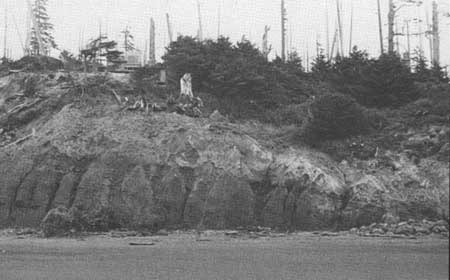
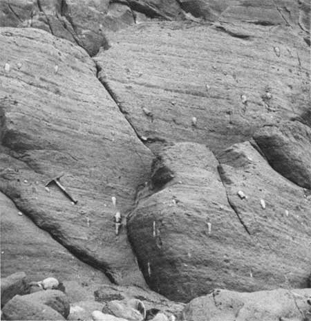
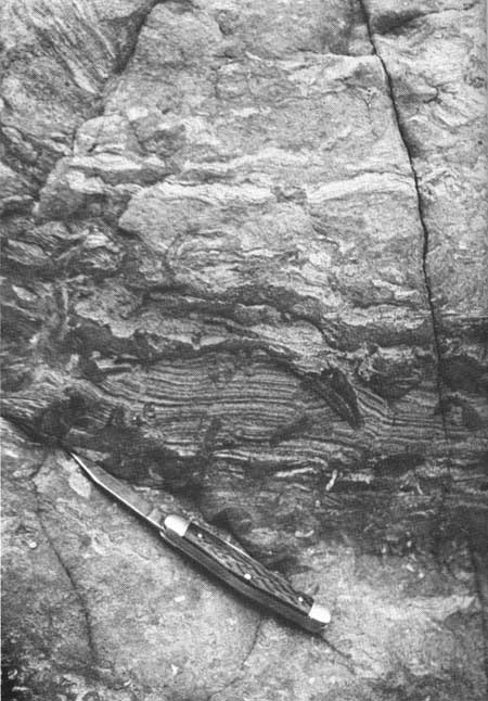
The base of the fourth and thickest section is clearly visible at the north end of its outcrop area (fig. 18). There, siltstone strata of the Quinault Formation rests unconformably on older, dark-colored and jumbled rocks of Hoh melange. The contact between the two units dips gently to the southeast. Lithologically the basal part of the section exposed north of Pratt Cliff is mostly well-bedded, sandy, fossiliferous siltstone, and in places thin-bedded, fine-grained sandstone. Concretionlike structures measuring from 4 to 8 inches in length are common, particularly in the sandstone beds of the area. Almost all are oriented with their long axis perpendicular to bedding planes (fig. 19). Pratt Cliff, although inaccessible, appears from nearby offshore to be uniformly dipping beds, largely of siltstone and possibly some sandstone (fig. 36). The remaining part of the section south of Pratt Cliff is mostly massive or bedded sandy siltstones containing scattered fossils. In many places throughout much of the lower part of the section in the Duck Creek area, bedding of individual strata appear to have been churned or disrupted before the sediments were consolidated (fig. 20).
|
| A CONTACT between the dark-colored jumbled Hoh rocks and the overlying tighter colored siltstone beds of the Quinault Formation, exposed in the cliff about three-fourths of a mile north of Pratt Cliff. (Fig. 18) |
|
| ELONGATED CONCRETIONLIKE STRUCTURES in bedded sandstones of the Quinault Formation exposed in the cliffs north of Pratt Cliff. These structures may have been cavities that were formed by boring animals, perhaps clams, and then were filled with sediments with slightly more cementing material than the surrounding sand. (Fig. 19) |
|
| DISRUPTED BEDDING in siltstone of the Quinault Formation of the Duck Creek area. The burrowing of clams or other marine organisms, together with local slumping of individual beds on unstable submarine slopes before the formation was consolidated, may have been responsible for this phenomenon. (Fig. 20) |
Fossil Foraminifera indicate that the strata of the Duck Creek-Pratt Cliff section of the Quinault Formation most likely were deposited in cool water at depths between 400 and 1,000 feet.
Tunnel Island Area
Although most of the Quinault Formation is represented in the four major sections previously discussed, an additional and sizeable series of discontinuous outcrops extend from Tunnel Island northward for a distance of over 1 mile. The sandstone strata exposed on Tunnel Island (fig. 24), in nearby sea stacks (fig. 25), and in the cliff immediately north of the mouth of the Raft River are all a part of the Quinault Formation. Northward to the end of the outcrop area, sandy siltstone beds are exposed in isolated areas in the cliffs and along the beach during low tide. Both megafossils and microfossils occurring in this series of outcrops suggest that the rocks belong to a lower part of the Quinault Formation, similar to those beds exposed immediately north of Pratt Cliff.
| <<< Previous | <<< Contents >>> | Next >>> |
state/wa/1973-66/sec1-3.htm
Last Updated: 28-Mar-2006