
|
Geological Survey Professional Paper 1547
Sedimentology, Behavior, and Hazards of Debris Flows at Mount Rainier Washington |
FLOW MAGNITUDE AND FREQUENCY
(continued)
FLOWS OF INTERMEDIATE MAGNITUDE AND FREQUENCY (100 TO 500 YEARS)
Debris flows in this intermediate range were analyzed for the time following the deposition of tephra layer Yn (3,400 radiocarbon years) or C (2,200 radiocarbon years), depending on drainage. Erosion or burial by the inset deposits of younger flows prevents a complete analysis of the intermediate-size flows older than these tephras. This span of 2,200-3,400 years is a sufficient period of record for these flows because the types of debris flows that occur at Rainier have not changed significantly in postglacial time. Intermediate-size flows are dominated by noncohesive lahars and their runouts (table 3). The runout phases consisted primarily of hyperconcentrated streamflow, which extended to the Puget Sound lowland or to a large down stream flood plain at least several times in all drainages except the Carbon River.
WHITE RIVER SYSTEM
Sequences of noncohesive lahars and their runout phases occurred at the following times: before the Osceola Mudflow; after the Osceola and before set C; between sets C and W; and after set W (table 3). Pre-Osceola flow deposits are seen only at the few places where the base of the Osceola Mudflow is exposed. All of these sequences are exposed near the Mud Mountain Dam and, therefore, at least locally inundated the downstream Puget Sound lowland.
The largest flows are between tephra sets C and W in age. They probably resulted from the volcanism that was responsible for construction of the summit cone during part of this time interval (table 1). Because the flows were dominantly noncohesive, most of them probably originated as meltwater flood surges that bulked with sediment on the side of the volcano and then debulked, in most cases beginning near the base of the volcano. The melting may have been the result of lava flows, pyroclastic flows and surges (both mainly lithic in composition), steam eruptions, or extensive geothermal heating.
Where approximately synchronous flows occurred in more than one watershed, they are probable evidence of significant episodes of volcanic or geothermal activity. Tephra-producing eruptions were not a general cause of the flows. Only pumice of tephra set C, which was erupted about 2,200 radiocarbon years ago, is found in significant amounts in any flow deposit, and radiocarbon dating shows that this pumice was mainly entrained through erosion. Some flows originated from shallow landslides, indicated by a high content of lithologically similar, hydrothermally stained clasts.
The largest noncohesive flows in the White, Nisqually, and Puyallup River systems probably formed about the same time, if not synchronously, from summit-cone volcanism. Crandell (1971) did not describe the runout phases of lahars, but he noted that the extensive aggradation in the White and Nisqually River systems, which resulted largely from runout flows, could be ascribed to summit-cone volcanism. That volcanism may have begun near the time of the block-and-ash flow in the South Puyallup River valley, 2,350 radiocarbon years ago (Crandell, 1971).
| Location | Stratigraphy and significance | Age1 |
White River (including West Fork) | ||
| 4.8 km upstream from confluence of Buck Creek and White River. | Trees killed by burial by flood deposit of nonvolcanic origin. | 400±75 |
| 2.3 km upstream from White River Campground | Wood in upper part of lahar-runout deposit, 1.0 m thick | 810 ± 75 |
| Confluence of Fryingpan Creek and White River | Wood in Dead Man Flat lahar assemblage; unit includes layer-C pumice. | 1,120 ± 80 |
| In West Fork, 6km upstream from confluence with White River. | Stump on large lahar-runout flow deposit, more than 1.8 m thick, overlain by 7 layers of flood deposits. | 1,255 ± 130 |
| 1.6 km upstream in Clearwater River | Wood below lahar-runout flow from Mount Rainier; a maximum age. | 3,005 ± 230 |
| 1.3 km upstream from confluence of Buck Creek and White River. | Charcoal fragments from base of noncohesive lahar beneath Osceola Mudflow. | 5,230 ± 235 |
| 1.3 km upstream from confluence of Buck Creek and White River. | Charcoal fragments from noncohesive lahar underlying above unit and overlying layer O. | 6,075 ± 320 |
Cowlitz River | ||
| South bank of active channel 1.8 km upstream from Randle (river mile 104.3 on Randle 15-minute quadrangle). | Wood in lowest of four silty sand overbank deposits, 0.2100.5 m thick, representing floods occurring after youngest lahar-runout flow. | 325 ± 180 |
| North side active flood plain 10km downstream from Randle (river mile 117.5). | Wood from base of 0.5 m silt layer over lahar-runout flow with layer-C pumice; dates major flood. | 440 ± 70 |
| South bank of abandoned meander 5.5 km upstream from Randle (near river mile 108.0). | Charred wood bioturbated with set W, in upper part of lahar-runout deposit, below 1.0 m of silt representing large post-W flood. | 815 ± 120 |
Nisqually River | ||
| 12.5 km upstream from main bridge crossing river near Yelm. | Bark from silt-rich unit burying cedar forest; dates flow that killed flood-plain forest. | 220 ± 70 |
| 1.2 km upstream from boundary of Nisqually Indian Reservation. | Wood from same unit as above | 240 ± 60 |
| 0.5 km downstream from National | Wood from lahar-runout flow younger than National; inset sequence in gorge cut in valley bottom. | 410 ± 75 |
| 1.4 km upstream from boundary of Nisqually Indian Reservation. | Outermost wood of 250- to 350-yr-old cedar buried by two silt-rich flood deposits; tree grew on deposit correlated with the National Lahar. | 585 ± 125 |
| 6.2 km downstream from Alder Reservoir | Wood within upper part of 3 m of hyperconcentrated-flow deposits correlated with the National Lahar. | 790 ± 205 |
| 1.6 km downstream from bridge crossing Nisqually River in National Park. | Wood from top of fluvial unit underlying transition facies of National Lahar; maximum date of that flow. | 2,285 ± 155 |
Puyallup River | ||
| 0.1 km upstream from main highway bridge below Electron. | Charcoal fragments from contact between lahar-runout flow and underlying large cohesive lahar. | 840 ± 190 |
| Do | Charcoal fragments from contact between lahar-runout flow and overlying large noncohesive lahar. | 2,740 ± 230 |
| Do | Charcoal fragments in lahar-runout flow under large non-cohesive lahar. | 3,530 ± 255 |
Carbon River | ||
| 4.8 km downstream from glacier terminus | Probable lahar-runout deposit in low terrace (2—4 m above active channel). | 650 ± 120 |
1Years before 1950 in radiocarbon years.
The largest post-C, pre-W noncohesive flows in the White River system are informally designated as the Dead Man Flat lahar assemblage (fig. 6), believed to consist of several nearly synchronous flows, at least one from each fork of the White River. The flows of the assemblage are lahar-runout flows over most of their longitudinal extent. Wood from the flow in the main fork at Fryingpan Creek yields a date of 1,120±80 radiocarbon years (table 4). Although layer-C pumice is abundant in this flow deposit, the date, from a limb segment with bark that was completely contained within the deposit, is probably an accurate measure of flow age. The flow deposit is immediately overlain by a unit interpreted as a blast deposit, with a radiocarbon age of 1,080±25 years (table 1) determined by R.P. Hoblitt (U.S. Geological Survey, oral commun., 1994). The flow apparently came down the main fork and did not originate in Fryingpan Creek. Downstream from the National Park boundary near Buck Creek, the transition facies of this flow locally overtopped the mound-bearing Osceola surface as much as 60 m above the White River (fig. 6A). Downstream from the confluence with the West Fork, the runout deposits of the flow are interbedded with those of a similar flow, also containing set-C pumice, which probably originated in the West Fork White River at about the same time. The outermost wood of a small stump on a large runout deposit along the West Fork yielded a date of 1,255±130 radiocarbon years (table 4). Even though the tree was 55 years old, its corrected age (1,310±130) still overlaps with the radiocarbon date (1,120±80) for the Dead Man Flat assemblage on the main fork. Total thickness of the assemblage, bounded by sets Y and W, is locally more than 3 m. From 6 km below Greenwater to the Mud Mountain Dam (fig. 6B), deposits of the assemblage occur at least 30 m above the White River. Even 11 km beyond the Cascade Range front, the flows reached nearly 20 m above the present river.
The dated occurrences of noncohesive flows show a concentration near but well beyond the end of the period of summit cone volcanism. This period was interpreted by Crandell (1971, p. 14) to be between 2,100 and 1,200 absolute years ago, about the same as the range in radiocarbon years (Stuiver and Becker, 1986). Dating of the noncohesive flows in the White and other river systems indicates that the lahar-producing volcanism continued to at least 800 years ago. Wood fragments from deposits of a small flow upstream from the White River Campground yielded a date of 810±75 radiocarbon years (table 4). A flood deposit that extensively aggraded the present White River channel and killed many trees contains wood yielding an age of 400±75 radiocarbon years. The deposit was only locally emplaced as a debris flow and is dominated by non-Rainier and reworked Rainier rock types. It is probably of nonvolcanic origin.
COWLITZ RIVER SYSTEM
Typical lahar-runout flow deposits occur throughout the Cowlitz River system, from the headwaters of the Ohanapecosh River to cutbanks in the flood plain near Packwood. The watershed was notably less affected by lahars and lahar-runout flows than either the White River system to the north or the Nisqually River system to the west. This difference probably reflects the lack of major, deeply incised valleys in the sector of the volcano drained by the Cowlitz River. Although the three separate flows observed (table 3) were overbank, they were not markedly greater than historical floods in the watershed. An overbank thickness of about 0.5 m is typical for the lahar-runout deposits upstream and downstream from Packwood and is comparable to the thicknesses of interbedded flood deposits (table 4). The lahars observed in the upper Muddy Fork (table 3) average about a meter in thickness, a value also comparable to the thickness of younger flood deposits in that area.
Except for one locality, radiocarbon dates could be obtained only from flood deposits overlying the runout flows. A date from wood within a runout deposit was 815±120 radiocarbon years (table 4). Other minimum ages of runout flows, and the probable actual radiocarbon ages of major-flood deposits occurring above them, are 440±70 and 325±180 radiocarbon years. The dated runout deposit is consistent in age with others in the White, Nisqually, and Puyallup River systems (table 4).
NISQUALLY RIVER SYSTEM
The oldest noncohesive lahar and runout flow to be recorded at multiple locations is pre-Y in age. It occurs at scattered exposures upstream of Longmire, indicating an origin from the part of the watershed headed by the Nisqually Glacier. Although not seen in direct contact with the Paradise Lahar, it is probably younger. Other pre-Y flows certainly existed, but their deposits were seen at only a single locality and could not be correlated. Characteristics used to correlate flow deposits in the absence of age information include soil development, matrix color, alteration products on and in clasts, and deposit texture.
A series of noncohesive lahars and lahar-runout flows occurred between the deposition of tephra sets Y and W (table 3). The flows were part of the aggradational cycle that resulted from summit-cone volcanism, as described above for the White River system. At some localities, set P (3,000 to 2,500 radiocarbon years in age) can be distinguished for further age refinement (figs. 9 and 1 1B). Because none of the Rainier tephras are present on the west side of the volcano, which faces prevailing winds, further tephra-based dating was not possible.
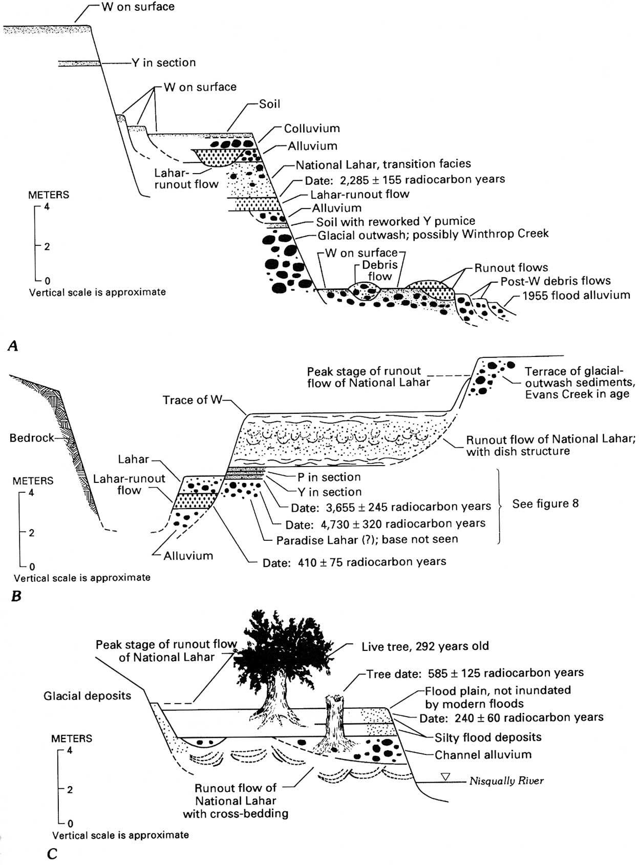
The best exposed lahar of this series, comparable in size with those in the White River system, can be traced to Puget Sound and is here informally named the National Lahar after the town of National (figs. 9 and 11B), a designation incorporating the runout phase. The National Lahar and its runout phase have textures typical of a noncohesive lahar and its hyperconcentrated runout-flow deposits (fig. 2). Mean grain size of the lahar is —1.2 f (2.3 mm); sorting is a relatively low 2.0 f, barely within the range characteristic of flows with sufficient strength to support dispersed coarse clasts (Scott, 1988b). Mean grain size of the runout deposits is +0.5 f (0.7 mm); sorting is 1.3 f, within the range common to runout flow deposits (1.1 to 1.6 f; Scott, 1988b) and reflecting the progressive downstream loss of strength. The lahar transformed to hyperconcentrated flow near the National Park boundary, as indicated by flow deposits consisting of the transition facies (Scott, 1988b, fig. 10) above Longmire. The flow may have originated in more than one tributary of the Nisqually River, but a significant part of the flow was derived from the headwaters of the main stream. The inclusion of erosionally derived clasts of tephra layer C, which was distributed mainly to the east of the volcano but also into the upper Nisqually River watershed (Mullineanx, 1974, fig. 24), supports this probability. Downstream from the National Park boundary, the deposits are largely those of hyperconcentrated flow. The further transformation to normal streamflow is marked by the appearance of well-defined stratification and of sorting below 1.1 f. Mean grain size of the deposits near Yelm is 3.1 f (0.1 mm); sorting is 0.6 f.
|
| Figure 11. Diagrammatic composite sequences of valley-fill deposits in the Nisqually River valley (successive downstream sections). Vertical scale is shown to indicate approximate thicknesses. Horizontal scale is variable for better portrayal of stratigraphic relationships and is not shown. However, vertical exaggeration ranges approximately between 5x and 10x . A, Nisqually River upstream from Longmire. B, Nisqually River between Ashford and National. C, Nisqually River downstream from Yelm. (click on image for an enlargement in a new window) |
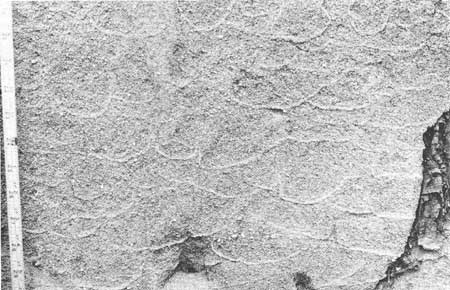
A noteworthy feature of the runout phase of the National Lahar is the presence of dewatering structures (fig. 12). Dish structure, named by Wentworth (1967) and correctly interpreted by Lowe and LoPiccolo (1974), is well developed in the longitudinal interval representing the upper part of the hyperconcentrated range of sediment content. This interval corresponds to the approximately 30 km of flow downstream from the distal end of the transition facies, the point at which the transformation from debris flow to hyperconcentrated flow was complete. Dish structure in the runout deposits of the National Lahar consists of concave-upward, strata-like concentrations of darker, commonly finer sediment that truncate each other laterally and locally resemble cross strata. Concavity increases upward within 2- to 3-in sections of the runout deposits, locally producing closed, concretionary forms near the top of the unit. The structure clearly is not antidune cross-bedding as interpreted by Wentworth. The basic mechanism is, as interpreted by Lowe and LoPiccolo, expulsion of water from the deposit shortly after deposition. However, the more pronounced development of the structure in older runout flows, such as that of the National Lahar, indicates additional progressive development with time as phreatic processes further concentrated fine sediment at the interfaces. Pillar structure (Lowe and LoPiccolo, 1974) is present along with the dish structure in some runout deposits, but is less common than in the deep-water marine sequences from which both structures have been previously recorded.
|
| Figure 12. Dish structure in deposits of National Lahar at the type locality. Note that the concavity of the "dishes" increases upward in the section. Structures shown are about 1 m below the top of a 3-m section. Scale at left is in inches. |
The type section of the flow deposit consists mainly of the lahar-runout phase in a quarry near National (fig. 9). Most attempts to date "wood" fragments in the unit yielded ages either too old (inconsistent with ages of underlying deposits, as well as known tephra ages) or too young (inconsistent with the age of trees growing on the surface). Some of the fragments that resemble carbonized wood were found to be inorganic during analysis; others are low-grade coal derived from Tertiary bedrock. Two dates establish a probable age, however. Wood within the upper, possibly reworked part of the unit below Alder Dam (table 4) yielded a radiocarbon age of 790±205 years. Near the end of the river system, a cedar tree growing on the correlative deposit died 585±125 radiocarbon years ago. This date is from its outermost wood and corresponds to an absolute age of about 550 to 650 years (Stuiver and Becker, 1986). Inasmuch as the tree was 250 to 350 years old when it died, the age of the deposit is at least 800 to 1,000 years. Upstream, trees growing on the sequence containing the flow deposits are at least 800 years old (Crandell, 1971, p. 42). In the White River valley, the most likely correlative surface is probably at least 1,000 years old (Sigafoos and Hendricks, 1961, p. 16). The National Lahar may be a close or synchronous correlative of the Dead Man Flat lahar assemblage in the White River. The lahar of that assemblage in the main fork of the White River has a radiocarbon age of 1,120±80 years. Both the National Lahar and the Dead Man Flat lahar assemblage contain abundant clasts of erosionally derived layer-C pumice.
The carbon content of the National Lahar is high, indicating that it occurred after a large forest fire. Evidence from other parts of the Mount Rainier area shows that at least one such fire did occur in the interval between tephra sets Y and W. Crandell (1971, p. 57) found forest-fire debris in a bank of Tahoma Creek, and he tentatively correlated it with the block-and-ash flow, 2,350 radiocarbon years in age, in the South Puyallup River valley. A remarkable layer of forest-fire debris was found in the banks of Kautz Creek upstream from the Wonderland Trail bridge, and wood from this layer yielded a date of 1,625±70 radiocarbon years. The National Lahar, if associated with a fire, expectedly would contain carbonized wood, but none was found. This suggests either that the flow occurred much later than the fire, after flushing of charred wood from the watershed, or earlier than the fire. The presence of carbon-impregnated rock suggests the former possibility.
The maximum age of the National Lahar is limited by included clasts of tephra layer C, with an age of 2,200 radiocarbon years; set P, which underlies the unit and has an age of 3,000 to 2,500 radiocarbon years; and a date of 2,285±155 radiocarbon years from wood below the unit upstream from Longmire. The maximum possible age is more closely bracketed by samples from beneath the unit, which yield ages of 1,820±300 and 1,970±250 radiocarbon years (R.P. Hoblitt, U.S. Geological Survey, oral commun., 1994).
Another noteworthy feature of the runout phase of the National Lahar is the distance over which the flow was hyperconcentrated, a total of more than 40 km from near National to downstream of Alder Reservoir. Long distances of hyperconcentrated flow were common to most lahar runouts at Mount Rainier.
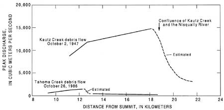
Younger noncohesive lahars, debris flows, and their runout phases in the Nisqually system (table 3) include: (1) flows occurring shortly before and after the National Lahar (fig. 11A, B); (2) lahar-runout-flow deposits interbedded with flood-plain gravel near the National Park headquarters between Ashford and Elbe; (3) a lahar-runout flow exposed in the gorge upstream from National; and (4) the runout phase of the largest of the 1947 debris flows, which originated as glacial-outburst floods in response to precipitation. This last flow, although recent, is a probable example of a flow with an intermediate magnitude and recurrence interval (100 to 500 years). This conclusion is based on its inundation area (it locally overlies set W and inundated a valley width of 0.9 km at the highway crossing) as well as the magnitude of its discharge (fig. 13) and deposit volume. In terms of estimated peak discharge, the flow was at least 10 times larger than any other 20th-century flow in Kautz or Tahoma Creeks.
The 1947 flow was the largest of a series of flood and debris flow surges that occurred mainly on October 2—3 in response to an intense cloudburst that caused the lower 1.6 km of the Kautz Glacier to collapse. Areas of stagnant ice resulting from long-term Neoglacial recession are major factors contributing to the formation of these modern flows, which are discussed more fully in the section on smaller, more frequent flows. Inasmuch as the 1947 flows are well described by Grater (1948a and 1948b), Erdmann and Johnson (1953), Richardson (1968), and Crandell (1971), only a general description is given here, along with any new details relevant to our topic.
Each 1947 debris flow was clearly noncohesive; Erdmann and Johnson (1953) recorded a "more or less complete absence of clay." Two composite samples of complete flow units contained 1 percent or less of clay. Crandell (1971) reported 4 percent clay in two matrix samples. A well-developed runout flow evolved from the largest 1947 debris flow; its deposit near the confluence of Kautz Creek and the Nisqually River is now a source of sand and granule gravel for aggregate, as are many other runout-flow deposits. Downstream, the flow was overbank only locally but can be traced to the western park boundary, 4.5 km downstream. Farther downstream at the gaging station at National, the flood wave had transformed from hyperconcentrated flow to normal streamflow; at that point the flow had attenuated to only 42 m3/s above base flow (Nelson, 1987).
The 1947 runout deposits are easily distinguished from older lahar-runout deposits of volcanic origin by their darker color, contrasting with the lighter, generally more yellow colors, typical of volcanic alteration, of the flows originating as lahars. The darker color is ascribed to the dominance of morainal streambed sediment as the main 1947 source materials. This sediment originated as ice-shattered debris scoured and eroded from the surfaces of relatively unaltered lava flows. Headwalls above Kautz Glacier expose flows (frontispiece) less altered than those above Tahoma Glacier in the Sunset Amphitheater, source of several flows in the Tahoma Creek valley. As much as 18.3 m of net channel erosion accompanied formation of the flows, deposits of which totaled 38 million m3 in volume along Kautz Creek (Grater, 1948a).
The 1947 runout deposits have size distributions typical of hyperconcentrated streamflow derived by direct transformation from debris flow, as shown in figure 2 for the National Lahar and its runout flow. The main debris flow deposit has a bimodal size distribution, mean grain size of —2,1 f (4.2mm), and sorting of 3.8 f. More than 80 percent of grains in two samples of the runout flow are in the sand size range; the mean grain sizes in these samples are 1.0 and 0.9 f (0.5 mm), and their sorting values are 1.3 and 1.6 f, respectively.
The behavior of the main 1947 flow was similar to that of smaller, more frequent flows. Its peak discharge attenuated rapidly at places of rapid energy loss as sediment debulked from the flow (fig. 13), transforming the debris flow surges to hyperconcentrated streamflow. Unlike the smaller modern flows on both Kautz and Tahoma Creeks, however, the place where debulking was most rapid was not at the main slope inflection at the base of the volcano, but near the confluence with the Nisqually River. The energy loss was in response to a great increase in valley width and spreading of the flow across the maturely forested fan. The hazard implications of the rapid attenuation and debulking of noncohesive flows are discussed in the section on risk analysis.
|
| Figure 13. Discharge versus distance for two debris flows resulting from glacial outburst or collapse. Rapid decline of discharge downstream reflects debulking of sediment in response to valley expansion, slope reduction, or confluence with streamflow. |
PUYALLUP RIVER SYSTEM
Flows in this drainage are dominated by large, mainly cohesive lahars, the valley-bottom deposits of which would have buried most runout deposits of the generally smaller, noncohesive flows. Several deposits of noncohesive flows were seen, including the large noncohesive lahar described in the section on large, infrequent flows. That flow extended as debris flow for at least 6.0 km beyond the lowland boundary and is the most far-reaching noncohesive lahar known from Mount Rainier. It is directly overlain and directly underlain by lahar-runout-flow deposits (tables 3 and 4), and the younger, overlying runout unit is evidence of an upstream lahar nearly synchronous with the large noncohesive lahar.
CARBON RIVER SYSTEM
Most of this river system consists of a deeply incised bedrock gorge from which any volcaniclastic flow deposits have been eroded. A ridge extending north of the summit may have diverted some noncohesive flows originating at the summit to the White or Puyallup River systems (Crandell, 1971). Crandell observed a lahar in the headwaters, and we noted two valley-wide lahar-runout deposits that are pre- and post-W in age. Set W was not found by Mullineaux (1974, fig. 18) to extend significantly into the watershed, but a distal facies of that tephra is locally recognizable. Layer Yn is more widespread (Mulineaux, 1974, fig. 16). Its preservation at the surface on low valley-side slopes shows that no large flows have originated in the river system in the last 3,400 radiocarbon years. However, neither the diversionary effect of the ridge noted above nor the paucity of previous debris flows in the watershed changes its susceptibility to a future cohesive lahar originating as a sector collapse (Frank, 1985).
| <<< Previous | <<< Contents >>> | Next >>> |
pp/1547/sec2b.htm
Last Updated: 01-Mar-2005