
|
Geological Survey Professional Paper 1547
Sedimentology, Behavior, and Hazards of Debris Flows at Mount Rainier Washington |
FLOW MAGNITUDE AND FREQUENCY
(continued)
FLOWS OF HIGH MAGNITUDE AND LOW FREQUENCY (500 TO 1,000 YEARS)
Most of the lahars in this category originated directly from the large debris avalanches known as sector collapses (fig. 4). The major flows are listed in table 2, along with smaller flows of the same general origin. Many of the deposits were recognized and named by Crandell (1971). Size distribution measurements show that most are the deposits of cohesive debris flows, containing at least 3 to 5 percent clay. Consequently, most of the flows did not transform as they flowed downvalley for long distances. Some do not correlate with known episodes of volcanic activity (table 1), which has implications for hazards planning, as discussed later in the report.
| Flow | Clay (percent) |
Age1 | Drainage | Volume (km3) | Extent |
|
Broadly peaked flows that traveled a significant distance from the volcano | |||||
| Central part of Tahoma Lahar | 3-4 | Post-set W | Tahoma Creek; Nisqually River | <0.15 | Probably to Elbe. |
| Electron Mudflow | 6-11 | 530-550 | Puyallup River | 0.26 | Puget Sound lowland. |
| 1,000-yr-old lahar | 5-12 | 1,050-1,000 | Puyallup River | Possibly >0.30 | At least to Mowich River; possibly to Puget Sound lowland. |
| Unnamed lahar (possibly same as Round Pass Mudflow) | 4-5 | Same as below? | Puyallup River | --- | Puget Sound lowland. |
| Round Pass Mudflow (main part) | 4-5 | 2,170-2,710 | Puyallup River | --- | Puget Sound lowland. |
| Osceola Mudflow (probably includes Greenwater Lahar) | 2-15 | 4,500-5,000 | White River (main fork and West Fork). | 3 | Puget Sound lowland. |
| Greenwater Lahar (probably part of Osceola Mudflow) | <3 | --- | Main fork White River | --- | Puget Sound lowland. |
|
More sharply peaked flows that attenuated rapidly on or beyond the volcano | |||||
| Lahar from main avalanche from Little Tahoma Peak | <2-4 | A.D. 1963 | White River | 20.01 | White River Campground. |
| Avalanche on Tahoma Glacier (small derivative debris flow) | --- | 3A.D. 1910-1927 | Puyallup River | 40.01 | Below glacier terminus. |
| Round Pass Mudflow (part in Tahoma Creek) | 2-8 | 2,610-2,790 | Tahoma Creek; Nisqually River. | <0.1 | Unrecognized below Tahoma Creek. |
| Pre-Y lahar at Round Pass | 5>3 | >3,400 | Puyallup River; Tahoma Creek. | --- | Unknown. |
| Paradise Lahar (probably synchronous with Osceola Mudflow | 1-6 | 4,500-5,000 | Paradise River; Nisqually River. | 3~0.1 | At least to National. |
1 Years before 1950 in radiocarbon years, except as otherwise indicated.
2Avalanche volume, form Crandell and Falamestock (1965).
3Slightly modified from Crandell's (1971) estimate of 1910-1930.
4Avalanche volume.
5Estimated.
|
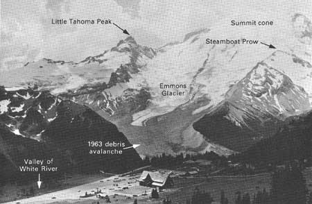
| Figure 4. View of northeast side of Mount Rainier (right) and Little Tahoma Peak (left center). Note large embayment, now partly filled by the snow-clad summit crater, which yielded the sector collapse that formed the Osceola Mudflow. The flow diverged across Steamboat Prow, the apex of the partly barren triangle of rock at the right side of the photograph, into the main fork of the White River (center), now the site of the Emmons Glacier, and northward into the West Fork White River (to right of photo). Dark rubble on surface of the lower part of the Emmons Glacier is from the 1963 debris avalanche originating from Little Tahoma Peak. |
As noted above, Crandell (1971) concluded that the critical clay content defining flows of avalanche origin is approximately 5 percent, whereas Scott (1988b) found that the clay content defining this origin at Mount St. Helens, as well as the limit below which the flow behavior was noncohesive, is close to 3 percent. However, this difference results largely from differences in sampling and analysis procedures. Therefore, rather than modify Crandell's data, we describe the critical limit here generally as 3 to 5 percent. Probably no absolute limit exists, but the actual separation of behavior types at both Mounts Rainier and St. Helens correlates best with a clay content of about 3 percent. The observed behavior-limiting clay content will vary, depending on overall size distribution and clay mineralogy as well as analytical technique. Field "pebble counts" can be strongly influenced by the presence of a few large clasts, and the results of laboratory analyses of cohesive deposits are extremely sensitive to technique.
An interesting correlation exists between flow volume, and thus avalanche volume, and the clay content of the resulting lahars. The larger the flow, the greater the clay content (fig. 5). The implication is that the larger the flow, the greater the penetration of the collapse into the hydrothermally altered core of Mount Rainier. Hydrothermal alteration and, consequently, clay content logically increase toward the center of the volcanic edifice. Clay mineralogy supports this conclusion (Frank, 1985, p. 144—145). Near-surface clay-rich areas can yield small cohesive flows, such as the modern debris avalanche on the Tahoma Glacier (Crandell, 1971, p. 17); that flow (of relatively small volume) would be an exception if plotted on figure 5. A practical use of the overall relation is that in a downstream sequence of Mount Rainier lahars, those with the highest clay content tentatively can be inferred to have been the largest. Much of the scatter in figure 5 is caused by the effects of scattered large clasts on the size distributions; clay content of only the matrix of each flow is more uniform.
In the following sections the flows relevant to hazard analysis are discussed in stratigraphic order of their deposits from oldest to youngest. The focus in each case is on aspects that are critical to analyzing risk: flow behavior, dynamics, and age. (Age is relevant chiefly for what it reveals about flow frequency.) Details of stratigraphy and exposure localities are not given here unless they have been changed or reinterpreted from Crandell (1971) on the basis of new exposures.
GREENWATER LAHAR AND OSCEOLA MUDFLOW
The Greenwater Lahar was described by Crandell (1971) as a hummocky, relatively low-clay lahar that filled the White River valley to levels not surpassed at most locations by the subsequent, high-clay Osceola Mudflow (pl. 1). Backwater deposits of the Greenwater Lahar form mounds in many tributary valleys in the river system as mapped by Crandell (1971, fig. 6), and were described as undifferentiated lahar deposits by Frizzell and others (1984). The mounds are the surface expression of blocks of the volcanic edifice that were grounded or stranded in backwater areas. The unit has been interpreted as a debris avalanche (Siebert, 1984; Siebert and others, 1987). According to Crandell (1971), the Greenwater Lahar is overlain by the Osceola Mudflow and is differentiated from it by surficial mounds and a lower clay content of the matrix.
A deposit typical of the Greenwater Lahar contains 3 percent clay, without megaclasts included in the size distribution. Mean grain size (Mz of Folk, 1980) is —1.7 f (3.2mm), sorting (sG of Folk, 1980) is 5.1 f and skewness (SkG of Folk, 1980) is +0.04. The matrix of the Osceola is remarkably clayey; the composite deposit (matrix and coarse phases excluding megaclasts) contains 2 to 15 percent clay, with a mean of 7 percent (13 samples). Mean grain size is —0.3 to —5.7 f (1.2 to 51.0mm), sorting is 4.6 to 6.2 f and skewness is —0.05 to +0.48, with all but one value positive, indicating the excess of fine material typical of lahars. Longitudinal change in size distribution is variable, but a general downstream increase in mean grain size probably is the result of bulking of bed and bank materials coarser than clay, and from which the clay had largely been removed by hydraulic (or selective) sorting.
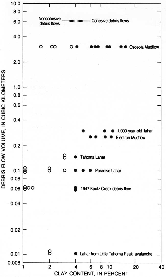 |
| Figure 5. Flow volume versus clay content in several postglacial debris flows at Mount Rainier. (click on image for an enlargement in a new window) |
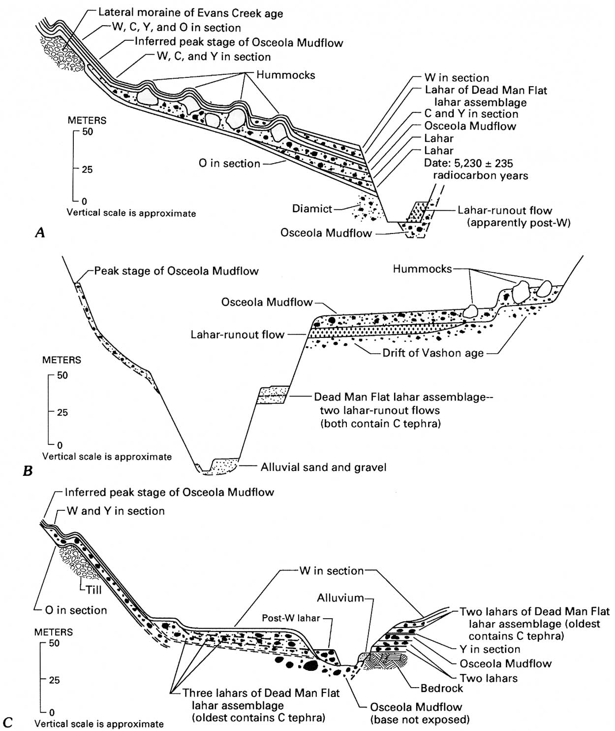
Four radiocarbon dates reported from the Osceola Mudflow by Crandell (1971) range from 4,700±250 to 5,040±150 radiocarbon years. Materials collected by us yield ages of 4,455±355, 4,980±200, and an older, age-limiting date of 5,230±235 radiocarbon years. The locations and implications of the younger dates are discussed below; the older date is from charcoal fragments above layer O but at the base of two pre-Osceola lahars near Buck Creek (fig. 6A). Those two flows probably are part of the pre-Osceola lahar assemblage described by Crandell (1971, p. 23) from upstream exposures, mainly on the south valley bank of the White River near Fryingpan Creek. Charcoal fragments from a third, older lahar, which is also near Buck Creek and is stratigraphically above layer O and below the Osceola, were 6,075±320 radiocarbon years in age. Both of the dated pre-Osceola deposits are noncohesive; the youngest pre-Osceola deposit is cohesive. Pre-Osceola lahars are also present in the valley of the West Fork White River (fig. 6C).
A new interpretation of the Greenwater Lahar and Osceola Mudflow in the White River system is suggested, largely based on new exposures, especially those near the confluence of Huckleberry Creek with the White River. Much of what is mapped as the Greenwater Lahar (Crandell, 1971, fig. 6) may be a peak-flow facies of the Osceola Mudflow with a high megaclast concentration, as inferred from the following evidence: the deposits of both lahars are present at the same level at several localities, such as Crandell's cross section A—A' near Buck Creek (Crandell, 1971, pl. 2), but, at the localities where the base of the younger Osceola Mudflow is exposed, it most commonly overlies lahar-runout deposits and Pleistocene glacial drift rather than Greenwater deposits. If the Greenwater Lahar is a separate unit, much time must have elapsed for it to have been so extensively eroded before occurrence of the Osceola Mudflow. A cohesive lahar locally underlies the Osceola near Buck Creek and at a locality near the confluence with the West Fork White River where there is no evidence of a significant time break between the two lahars.
Two terraces north of the Mud Mountain Reservoir, near the point of discharge to the Puget Sound lowland, are underlain by a mounded lahar. Moreover, 90 percent of the mounds, which are as much as 15 m high and 60 m across, have cores composed of Mount Rainier rocks, indicating an origin from the slopes of the volcano. Less than 1 km upstream along Scatter Creek, a small tributary of the White River on the north side of the Mud Mountain Reservoir, the Osceola and underlying Pleistocene drift crop out nearly continuously without an intervening Greenwater equivalent, indicating that the mounded deposits downstream are Osceola rather than Greenwater. We infer that Osceola megaclasts were grounded here and formed mounds as peak discharge passed downstream, allowing the more fluid matrix to drain away. Other mound-bearing deposits along the West Fork of the White River must be Osceola because the Greenwater Lahar is thought to have flowed down only the main fork of the White River (Crandell, 1971, fig. 6). Two levels of mounded deposits downstream from the confluence of the west and main forks of the White River are explained by pre-existing topography or by slightly different arrival times of the peak from each fork at the confluence.
The textural difference between Greenwater and Osceola deposits corresponds to that between the lateral mound-bearing deposits and the clay-rich valley deposits of the Osceola into which the White River is incised. If these are deposits of the same flow, the textural variation is explained by figure 5. The clay-rich valley deposits represent a late stage of flow, assuming the normal behavior of a lahar flood wave. Thus, these deposits were probably derived from fluidization of a deeper and more altered, clay-rich part of the volcano. This hypothesis is, in essence, not greatly different from the sequence of two flows proposed by Crandell (1971, p. 23) in which the first (Greenwater), formed from relatively unaltered surficial rock, exposed the underlying, altered part of the edifice for the sector collapse that produced the second (Osceola). Separate peaks in the same huge flow are possible, as in the sequence of slide blocks that produced the 1980 debris avalanche at Mount St. Helens (Glicken, 1986), but would yield deposits revealing their separation in time, however brief.
|
| Figure 6. Diagrammatic composite of valley-fill deposits in the White River valley (successive downstream sections). Vertical scale is shown to indicate approximate thicknesses. Horizontal scale is variable for better portrayal of stratigrahic relationships and is not shown. However, vertical exaggeration ranges approximately between 5x and 10x. A, White River between Buck and Huckleberry Creeks. B, White River at Mud Mountain Reservoir. C, West Fork White River between 25 km from Mount Rainier and confluence with main fork of White River. (click on image for an enlargement in a new window) |
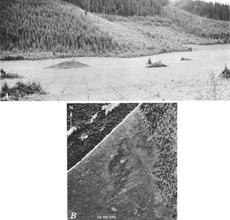
At the confluence of the White River and Huckleberry Creek, almost the entire backwater fill of mounded material, mapped as the Greenwater Lahar (Crandell, 1971, fig. 6), has been cleared of vegetation (fig. 7A). Aerial photographs of the clearing (fig. 7B) show, in addition to topographic mounds, abundant ghost-like shapes, some of which we interpret as disintegrated megaclasts. The disaggregation of blocks of relatively unaltered material, both during flow and after deposition, may partially explain the mounded, relatively low-clay backwater deposits and thus their contrast with the clay-rich deposits in the central valley. In addition, size analysis of material between megaclasts in an extreme backwater position shows a prominent mode in the sand range, as in a typical noncohesive lahar, and it is likely that some of this sand originated by bulking during passage of the locally erosive peak of the flow. Calculation of the overall proportion of eroded sediment in the deposits at this point, by means of the lahar-bulking factor (LBF), shows that material derived by bulking of stream and valley sediment makes up at least 20 percent more of the sediment (excluding megaclasts) in the mounded deposit near the lateral margin than in the cohesive central-valley deposits. Our preferred hypothesis thus is that these two types of deposits (noncohesive with abundant megaclasts and cohesive with fewer megaclasts) are facies resulting from a single large flow wave.
|
| Figure 7. Mound-studded surface of the Osceola Mudflow in the embayment formed by the tributary valley of Huckleberry Creek. A, View upstream across the cleared surface of the deposit. Note the gentle slope of the lateral deposit toward the White River, behind and to the left of the photographer. Largest mound visible, left of center, is approximately 3 m high. B, Aerial view of part of same area on April 20, 1982. Note that some masses that are possible megaclasts are not topographic mounds. |
Also at Huckleberry Creek, newly exposed Osceola Mudflow deposits overlie a thick glaciofluvial section in a gravel pit within 180 m of the nearest mound that, along with many others, protrudes from a level identical with the surface of the Osceola Mudflow. Wood from the basal 50cm of a 3.1-meter section of the Osceola Mudflow at the quarry yields the date of 4,455±310 radiocarbon years, evidence that the deposit is not of pre-Osceola age (table 2). Wood from the upper meter of the quarry section yields the date of 4,980±200 radiocarbon years, a date likewise conformable with an age of 4,500 to 5,000 radiocarbon years for the Osceola Excavation of the mound nearest the quarry to a depth greater than 4 m shows it to be enclosed by typical deposits of the Osceola Mudflow. The existence of two flows or two separate peaks requires, therefore, the unlikely coincidence that mounded deposits of the Osceola filled the valley to exactly the same level as did mounded deposits of the Greenwater Lahar. The lateral, but not central or distal presence of the mounds is explained both by megaclast disintegration during flow, and by the similarity of a debris flow path to the path of a tractor tread: "The coarsest clasts remain in the front and are deposited along the sides of the moving flow, but the finer debris is recycled * * *," continuing downstream because "* * * debris at the center and top of a channel moves faster than debris along the sides and bottom * * *" (Johnson, 1984, p. 287).
This interpretation does not change Crandell's interpretations of the volume of the Osceola or of its distribution underlying the Puget Sound lowland. It does indicate, however, that mounds are not diagnostic of a debris avalanche in the Cascade Range. The other two notably mounded deposits, the 1980 rockslide-debris avalanche deposit at Mount St. Helens (Glicken, 1986) and the huge hummocky landslide north of Mount Shasta (Crandell and others, 1984; Crandell, 1988), are both debris avalanches. Overall, the mound-bearing deposits in the White River system, be they Osceola or two separate flows, are best characterized as those of a lahar. The fill of backwater areas with muddy, horizontally surfaced deposits (excluding the mounds) indicates fluidity and strength in the range typical of lahars. The flow originated by collapse of a hydrothermally altered, water-rich edifice. The contrast between the presumed Greenwater deposits, with the hummocky surfaces of a debris avalanche, and the Osceola Mudflow deposits is the contrast between relatively clay-poor sources with less water, and clay-rich sources with more water. The deposits represent, respectively, the initial part of the flow wave (the "Greenwater Lahar"), composed of surficial, relatively unaltered rocks, followed by flow derived from highly altered, deep-seated materials (the Osceola Mudflow). The Round Pass Mudflow, Electron Mudflow, and Tahoma Lahar, described below, also contain megaclasts expressed as mounds in lateral facies. Each of these, like the Osceola, is a lahar inferred to have formed by mobilization of a debris avalanche.
The Osceola Mudflow contains weak megaclasts of unconsolidated, stratified gravel, sand, and silt that represent flood-plain deposits. Some such megaclasts were rotated from the horizontal; others were deformed. To document the proportion of eroded and disaggregated flood-plain sediment in the flow, we calculated the lahar-bulking factor from clast roundness, and we also compared the roundness and lithology of various clasts. The combination of LBF and rock type yields estimates of the proportion of material derived from the volcano, from valley-side slopes, and from the flood plain and channel.
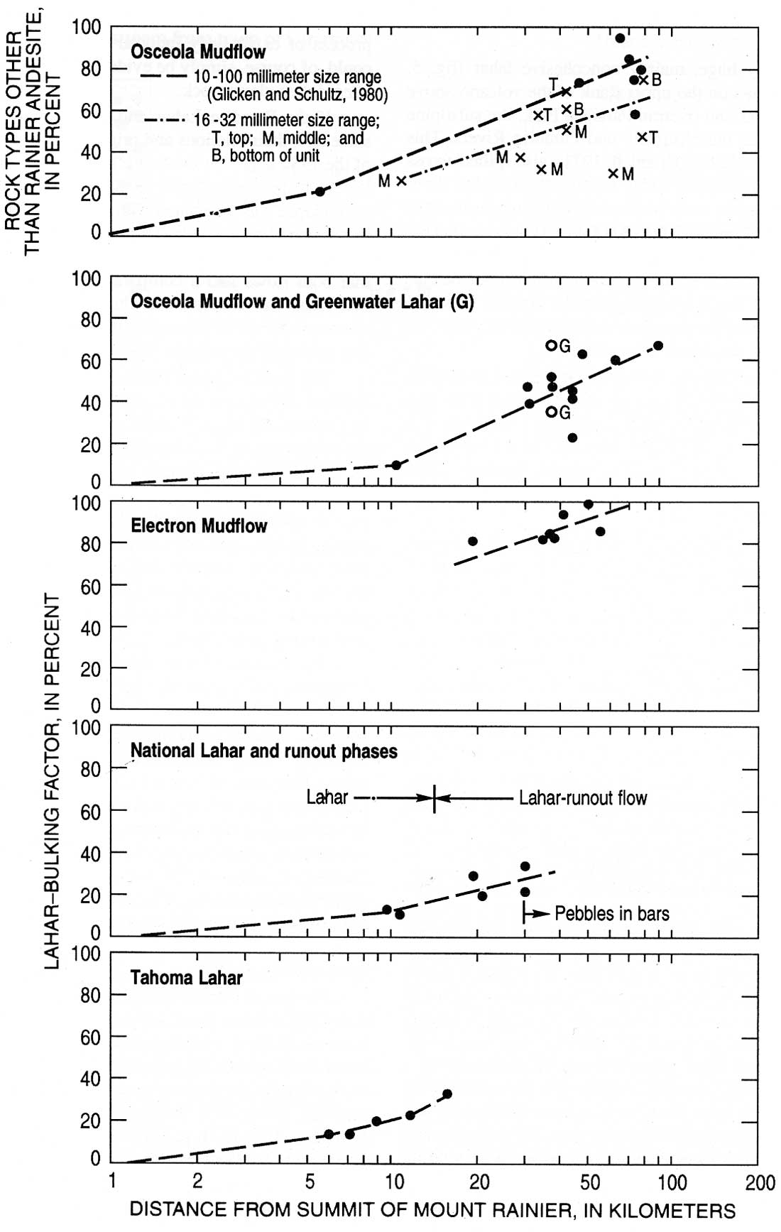
The results for all or part of the size range of —3.0 to —5.0 f (8 to 32 mm) (fig. 8) indicate that bulking was substantial and progressive, but slightly less than indicated by the composition analysis of Glicken and Schultz (1980). This general degree of bulking is probably applicable to most of the gravel-size sediment (—1.0 f and coarser; 2.0mm and coarser). Lesser but substantial amounts of bulking probably occurred in the sand (4.0 to —1.0 f; 0.0625 to 2.0 mm) and silt (8.0 to 4.0 f; 0.004 to 0.0625 mm) size ranges. Bulking did not add to the already high clay content of the flow; the bed material and channel deposits that compose most flood-plain sediment generally contain less than 1 percent clay. Variations in clast roundness with composition indicate substantial bulking from steep valley sides between the volcano and Greenwater, a distance of about 40 km. Farther downstream, the same comparisons indicate the increasing incorporation of more highly rounded valley-bottom sediment, especially on the drift plain of the Puget Sound lowland. The roundness of Mount Rainier rock types downstream indicates the incorporation of already rounded alluvial clasts. Bulking, although substantial, was not sufficient to increase the peak discharge of the lahar wave downstream. However, the flow volume obviously would have declined much more rapidly downstream had it not been for the effects of bulking, which accounted for at least 50 percent of sediment in the —3.0 to —5.0 f (8 to 32mm) size range after 60 km of flow.
|
| Figure 8. Lahar-bulking factors for four lahars at Mount Rainier, and composition changes in the Osceola Mudflow. (click on image for an enlargement in a new window) |
Clasts in the —3 to —5 f (8 to 32 mm) range with partially stream-rounded surfaces were examined for evidence of abrasion or breakage (cataclasis) during flow. Between 20 and 35 percent of the rounded clasts were broken, but only about half of these showed clear evidence that the breakage occurred during flow, rather than before or after. Coarse abrasion or grinding on clast faces was interpreted as the result of impacts with other particles during flow rather than glacial abrasion. Overall, cataclasis and grinding were nearly as abundant in the Osceola Mudflow as they were in the largest noncohesive lahar at Mount St. Helens (Scott, 1988a). This result occurred in spite of the probable cushioning effect of the more cohesive matrix in the clay-rich Osceola Mudflow.
PARADISE LAHAR
An initially huge, mainly noncohesive lahar (fig. 5, table 2) originated on the upper flank of the volcano above Nisqually Glacier and overran Paradise Park, the subalpine meadow between the Nisqually and Paradise Rivers. This flow, the Paradise Lahar (Crandell, 1971), also spilled across the demarcating Mazama Ridge to enter the Cowlitz River system. Radiocarbon dates within the same range as those of the Osceola Mudflow (4,500 to 5,000 years) indicate that the Paradise Lahar probably reflects the same edifice collapse as the Osceola Mudflow. What was most unusual about the Paradise Lahar was that it attenuated rapidly and left only thin deposits, in spite of having reached depths of more than 300 m in canyons on the side of the volcano.
The Paradise Lahar contains from less than 1 to as much as 6 percent clay with an average of 2.5 percent (four new composite samples). Mean grain size ranges from 0.6 to —2.8 f (0.7 to 6.9 mm); sorting falls between 2.5 and 4.9 f Skewness is generally slightly positive, ranging between —0.03 and +0.20. Fine sediment is not as abundant as in more cohesive lahars like the Osceola.
The Paradise Lahar is noteworthy for several characteristics: (1) The size distributions are strongly influenced by the presence or absence of widely distributed, hydrothermally stained clasts, including large boulders 2 to 3 m in intermediate diameter, set in a thin (less than 1.0 m) layer. (2) Crandell's measurements (1971, p. 33) of very large flow depths on the flank of the volcano were substantiated; consequently, the ratio of deposit thickness to original flow depth is very low. (3) These flow depths declined rapidly downstream, and thus the rate of flow wave attenuation, as in the Round Pass Mudflow on Tahoma Creek, is uncommonly high. (4) The deposit is also remarkable for its occurrence directly above layer O, revealing its inability to erode this very thin layer (less than several centimeters) of fine-grained tephra and forest duff where flow depths were more than 100 m.
The above four features lead us to infer that the flow began, essentially as interpreted by Crandell (1971, p. 35, 36), as one or more huge avalanches. We interpret this as having been only a single avalanche, which had a degree of sudden, laterally directed momentum to create a sharply peaked flow wave in which the sediment was in part dispersed. Although these features could be explained by a large vertical drop (Crandell, 1971, p. 36), we infer that the Paradise Lahar is more likely to have been initiated by volcanic or phreatic explosive activity than the more broadly peaked flows originating as sector collapses. Such an origin also reconciles any difficulties in comparing the apparent flow volume and the volume of deposits (Crandell, 1971, p. 36). A similar explosive origin was proposed for some lahars originating with the 1980 lateral blast at Mount St. Helens (Major, 1984; Pierson, 1985; Scott, 1988b). The low clay content of the Paradise Lahar may reflect loss of fines by the process of explosively induced sorting (Scott, 1988b) but could, of course, simply be evidence of formation from less altered, less clayey rock.
If the Paradise Lahar and Osceola Mudflow are the same age, their relations and origin are comparable to those of the 1980 lahars on the South Fork and North Fork Toutle Rivers, respectively (Scott, 1988b). In that case, a major sector collapse was associated with explosively initiated lahars in peripheral watersheds. The probable synchroneity of the Paradise Lahar with the Osceola Mudflow clearly suggests that both flows had a comparable explosive origin. Most likely, the Paradise Lahar resulted from concomitant failure of part of the rim of the crater formed by the sector collapse that produced the Osceola Mudflow.
The Paradise Lahar attained its maximum downstream depth of 240 m near the Ricksecker Point locality described by Crandell (1971, p. 36 and fig. 13), 1.2 km upstream from the confluence of the Nisqually and Paradise Rivers. Deposits at this locality contain charcoal yielding an age of 4,625±240 radiocarbon years.
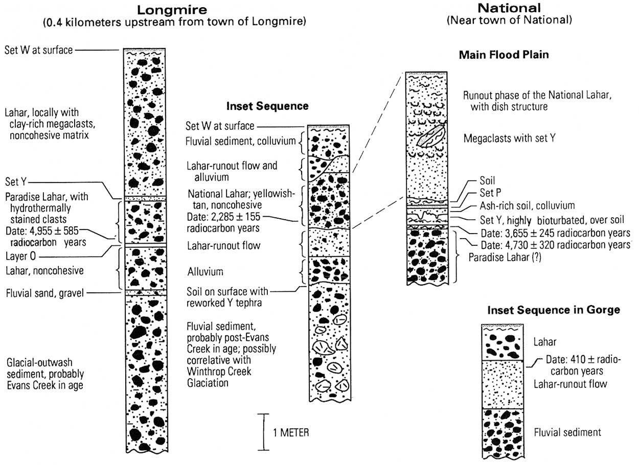
The depth of the Paradise Lahar declined rapidly down stream, but the flow was still at least 70 m deep near Longmire, where the deposit also overlies layer O, has only 1 percent clay, and is as much as 1.2 m thick. At that location, wood from just above layer O yields an age of 4,955±585 radiocarbon years (fig. 9).
|
| Figure 9. Composite columnar sections of lahars and associated deposits at Longmire and National in the upper Nisqually River drainage. (click on image for an enlargement in a new window) |
The Paradise Lahar is known to extend to Ashford (Crandell, 1971, plate 3), but it probably inundated the deeply incised flood plain of the Nisqually River beyond National. At least 1.0 in of a noncohesive lahar with hydro thermally stained clasts occurs below tephra set Y on the main valley floor at National (fig. 9); charcoal fragments in the upper part of the unit yield an age of 4,730±320 radiocarbon years. This probable distal part of the Paradise Lahar is evidence of a flow volume near the upper limit of the range proposed by Crandell (1971, p. 36). Although the flow was generally noncohesive, a runout phase has not been identified, possibly because of the age of the flow and the consequent loss of the deposit by erosion or burial by later, post-set-Y aggradation.
No dates for the Paradise Lahar were reported by Crandell (1971) who noted, however, that the flow occurred between the times of tephra layers O and D, a range between about 6,800 and 6,000 radiocarbon years ago (table 1). The reason for the discrepancy with the three radiocarbon dates reported above was investigated. Interestingly, Crandell (1963a, p. 138; 1971, p. 35) originally thought the Paradise Lahar and Osceola Mudflow were the same age before the tephra evidence apparently negated the possibility. Our radiocarbon dates support Crandell's original inference; the new radiocarbon dates conform in near equivalence to the age of the Osceola, and conflict with the tephra evidence. One possible explanation for this conflict is that the "Paradise Lahar" deposit on which Crandell based his tephra stratigraphy may actually be a nearly identical but somewhat older flow. He reports (1971, p. 33) a thin Paradise Lahar deposit underlying layer D on the east side of Paradise Valley near Sluiskin Falls. The tephras there confirm an older age, as does a date of 6,950±355 radiocarbon years obtained by us from wood collected from the lahar at the site. Thus, the main Paradise Lahar is, as originally surmised by Crandell, close to or synchronous in age with the Osceola, and the tephras correctly date an older, smaller lahar near Sluiskin Falls.
ROUND PASS MUDFLOW (BRANCH ON TAHOMA CREEK)
A large lahar is exposed at Round Pass from which flow diverged into both the Puyallup and Nisqually River drainages, the latter by way of Tahoma Creek (fig. 1B). Crandell (1971) showed that the branch on Tahoma Creek attenuated rapidly, is post-set Y in age, and has a radiocarbon age of 2,610±350 years. A date obtained by us from wood in valley-bottom deposits was 2,790±130 radiocarbon years.
The texture is highly variable at the three main exposures, ranging from cohesive to noncohesive as follows: Round Pass, 2—8 percent clay; valley bottom, unit 3 of Crandell's section 9, 3—5 percent; and Indian Henrys Hunting Ground, 3 percent. Mean grain size is between +0.5 and —3.5 f (0.7 to 11.0 mm); sorting ranges from 3.5 to 5.0 f (five samples). Skewness is not uniform in direction, varying between -0.10 and +0.18.
Rounded clasts, especially in the coarse fractions, characterize the unit at the type locality. A partial but less-than-satisfactory explanation is that valleys on both sides of Round Pass were filled with outwash gravel or debris-rich glacial ice to a higher level than they are now, and thus that the lahar was shallower than the present topography would suggest. In this event the lahar could have transported entrained material to the height of Round Pass. An early Neoglacial advance culminated in the time interval a synchronous advance probably occurred at Mount Rainier (Crandell and Miller, 1974). However, the lahar contacted the modern valley bottom only 3 km away from Round Pass, and Crandell (U.S. Geological Survey, written commun., 1989) does not believe that the Neoglacial advance could have filled the valleys significantly near Round Pass. Some rounded material in the lahar may have come from Evans Creek Drift in the vicinity (Crandell, 1969, pl. 1), and some undoubtedly came from local deposits of outwash gravel, which were probably more extensive and abundant than they are now.
The most likely origin of the flow was as a debris avalanche from the Sunset Amphitheater mainly confined to the watershed of the South Puyallup River. The part spilling over into the Tahoma Creek valley, although possibly more than 300 m deep in the headwaters of Tahoma Creek, apparently attenuated rapidly and was a sharply peaked distributary of the flow, subsidiary to the main part that traveled a longer distance in the Puyallup River valley. The pattern of erosion of tephra set Y by the Round Pass Mudflow clearly reveals the dynamics of the flow and shows that Crandell's (1971, fig. 25) interpretation of rapid attenuation is the most likely explanation of its limited extent along Tahoma Creek. The unit's most distal exposure in that valley is 3 km upstream from the mouth of Tahoma Creek, where it supported a forest inundated by the younger Tahoma Lahar.
ROUND PASS MUDFLOW (BRANCH ON PUYALLUP RIVER)
The behavior of the Round Pass mudflow in the Puyallup River system was substantially different from that of the sharply peaked distributary of the flow to the south. The initial flow was a broad lahar wave that probably reached the Puget Sound lowland. Ages of 2,710±250 and 2,170±200 radiocarbon years were obtained by Crandell (1971) from wood near the confluence with the Mowich River. A piece of wood collected by us at the same location yielded an age of 2,440±290 radiocarbon years. The flow overran a forest 4.5 km upstream from the confluence of the North and South Puyallup Rivers, just outside the park boundary. The outermost 10 rings of a buried tree from that forest yielded an age of 2,600±155 radiocarbon years. Three of the four dates are, therefore, consistent with the age of the distributary of the flow in the Tahoma Creek drainage.
Clay content is variable, as in the deposits along Tahoma Creek, but the Puyallup River deposits are mainly in the cohesive category if megaclasts are excluded from the size distributions. Two upstream samples contain 4 and 5 percent clay, and downstream the deposits become more cohesive. Mean grain size of the upstream samples is —1.6 and —1.3 f (3.0 and 2.4 mm), respectively, sorting is 4.2 and 4.9 f, and skewness is slightly positive.
Where the unit is as much as 16 m thick near the confluence of the Mowich and Puyallup Rivers, large exposed megaclasts and the presence of many mounds farther upstream establish a slope-failure origin (as a debris avalanche) that is consistent with the generally cohesive downstream texture. That these mounded deposits probably are not those of an untransformed debris avalanche is indicated by their texture, both on Tahoma Creek and at the site of the buried forest mentioned above. At the latter locality the deposits between megaclasts have the character of a lahar, are generally cohesive in texture, and represent an upstream part of the flow distributed on the flank of the volcano as shown by Crandell (1971, fig. 25). The deposits in the upper Puyallup valley are more likely a mounded facies of a large lahar, similar in origin to the deposits mapped as the Greenwater Lahar.
Both flow depth and velocity were remarkable at the site of the buried forest near the park boundary. There the megaclast-bearing flow knocked down trees 240 m above the valley bottom on the south, outer side of a broad, northerly valley curve that begins upstream from Round Pass. The peak flow level is defined by a terrace with a mounded surface and a small, ephemeral lahar-margin lake. Estimates of minimum runup on lateral ridges strongly suggest a peak velocity of at least 40 m/s. Round Pass, only 3.0 km upstream from the buried forest, is 170 m above the valley bottom in a more confined reach; consequently, flow in the South Puyallap River valley was certainly deep enough to send a major distributary across Round Pass into Tahoma Creek as shown by Crandell (1971, fig. 25). Flow across divides farther upstream is even more likely. Concomitant with these findings is a probable hydraulic explanation of the high attenuation rate of the flow in the Tahoma Creek valley. Flow across the divides would have occurred only during the relatively brief passage of the peak of the high velocity flow, resulting in exactly the highly peaked, rapidly attenuating flow(s) recorded by the texturally variable deposits in Tahoma Creek valley.
A noncohesive lahar and lahar-runout deposit, which have bounding ages of 840±190 and 2,740±230 radiocarbon years, and an older runout deposit 3,530±255 radiocarbon years in age, occur 6.0 km downstream from the boundary of the Puget Sound lowland (fig. 10B). The youngest two of the three units, described below, could be distal correlatives of the Round Pass Mudflow based on their ages. However, we believe that neither of the units is a likely correlative because of their noncohesive texture. A more probable origin was as meltwater surges resulting from volcanism as in the case of the younger two deposits exposed upstream, which formed near or following the time of the block-and-ash flow in the South Puyallup River valley. The deposit of the block-and-ash flow is noncohesive (with only 1 percent clay), and it is 2,350±250 radiocarbon years old (Crandell, 1971). The Round Pass Mudflow probably extended to the Puget Sound lowland intact as a cohesive debris flow, untransformed to a hyperconcentrated runout.

|
| Figure 10. Diagrammatic composite sequences of valley-fill deposits in the Puyallup River valley (successive downstream sections). Vertical scale is shown to indicate approximate thicknesses. Horizontal scale is variable for better portrayal of stratigraphic relationships and is not shown. However, vertical exaggeration ranges approximately between 5x and 10x. A, Puyallup River at Mowich River confluence. B, Puyallup River 6.0 km downstream from boundary of Puget Sound lowland. |
UNNAMED PRE-ELECTRON DEPOSITS, PUYALLUP RIVER SYSTEM
The oldest postglacial lahar recognized during this study occurs above glacial drift and below set Y in the Puyallup River system (fig. 10A). The gray, generally noncohesive unit contains wood yielding an age of 10,175±365 radiocarbon years. Because tephra layers show that the valley configuration did not change greatly in postglacial time, the height to which the deposit extends above the present channel, about 100 m near the Mowich River confluence, indicates the flow was large.
Deposits of brown or gray cohesive diamicts of uncertain age and origin occur locally in the Puyallup River system (fig. 10A). Some exposures probably are of a non-megaclast-bearing facies of the Round Pass Mudflow; others are pre-Y in age, and their correlation is not certain. In any case, the units record at least one cohesive pre-Y, postglacial lahar that attained levels approaching, but below, the peak stage of the younger Electron Mudflow. South of the Mowich-Puyallup confluence (fig. 10A), a brown cohesive diamict underlies a strikingly monolithologic and noncohesive debris flow deposit consisting of clasts of black vitric Rainier andesite. However, at the upstream site of the buried forest, a megaclast of an identical deposit is incorporated in the Round Pass Mudflow, the identification of which is verified by a nearby radiocarbon date. Thus, the brown unit below the black lahar near the confluence is probably not the Round Pass Mudflow but is most likely a pre-Y lahar.
The monolithologic lahar reaches at least 43 m above the valley bottom near the Mowich River confluence. The lahar is granular and resembles a lithic pyroclastic flow, but it is distinct from the deposit of the block-and-ash flow exposed on the volcano (table 1). The unit very likely represents the cooled downstream continuation of such a flow, and it is closely similar to a pre-Osceola unit in the White River valley. The flow was probably larger than that producing the block-and-ash flow deposit seen on the volcano; that unit has not been traced downstream with certainty, although a granular, lithologically similar lahar with a pronounced content of prismatically jointed clasts is locally present beneath the Electron Mudflow in low, channel-bank exposures.
A large noncohesive lahar, untransformed to a runout phase, is recorded by deposits on the Puget Sound lowland in the Puyallup River system (table 3, fig. 10B). The age of the unit and its probable lack of correlation with the Round Pass Mudflow are discussed above in the section on the Round Pass Mudflow (Puyallup River branch). The lahar, which has an approximately 20-cm-thick, Type I sole layer (sandy, without a dispersed coarse phase), has inverse and normal grading identical to that of many granular lahars at Mount St. Helens (Scott, 1988b). The unit crops out at a level at least 6 m above the present river, 0.1 km upstream from the valley constriction at the first bridge upstream from Orting, and 6.0 km downstream from the lowland boundary. Clasts in the coarse mode are no larger than pebbles in size. The loss of coarser gravel and a locally intact framework indicate that transformation occurred not far downstream. Runout sands underlie and overlie the unit. The lack of weathering during the hiatus between the flows indicates that little time separated the lahar and the overlying runout deposit.
1,000-YEAR-OLD LAHAR
This clayey lahar extends down the Puyallup River system at least as far as a point 1.6 km below the mouth of the Mowich River (Crandell, 1971) but may have extended much farther. Wood yielding a radiocarbon date of 990±130 years was collected from beneath a clayey lahar, which is exposed in a roadcut 1.0 km up Fox Creek on the Puget Sound lowland. This lahar flowed into a reentrant, Vashon-age (Crandell, 1963b) hanging valley about 1 km upstream from the lowland and then into Fox Creek before reentering the Puyallup River. Because the height of this deposit above the present river (37 m) is typical of Electron deposits at this point, it is more probably the Electron Mudflow than the 1,000-year-old lahar. The possibility exists, however, that a cohesive lahar extended to the lowland about 1,000 years ago.
ELECTRON MUDFLOW
This cohesive lahar in the Puyallup valley (table 2) is like the Osceola Mudflow, although it is smaller in volume. Nevertheless, the Electron is still large, and its volume is more typical of the group of "large but infrequent" cohesive lahars that have formed at Mount Rainier in postglacial time. Like the Osceola, the Electron is relatively clay-rich (table 2, fig. 5) and has a significant LBF (fig. 8), which acted to reduce the rate of downstream attenuation and volume decline. The volume of deposits as measured by Crandell (1971, p. 57) on the Puget Sound lowland is accepted, but an additional volume representing an estimate of postdepositional erosion and dewatering losses is included in the value given in table 2. The lost volume was estimated by assuming an even, nearly horizontal original surface and then determining the volume represented by the difference between that surface and the present lower, dissected surface.
The clay content of the Electron Mudflow ranges from 6 to 11 percent with a mean of 8 percent (four samples). Its mean grain size is finer than that of the Osceola, in part because nearly all exposures are of thin deposits on steep valley side slopes; values range from +1.7 to -2.2 f (0.3 to 4.5 mm). Sorting ranges from 4.2 to 5.1 f, and skewness values are positive, from +0.06 to +0.38. The unit contains only a few scattered megaclasts, forming mounds on lateral deposits in upstream reaches; the deposits are notable for a relative scarcity of mounds compared to those of other flows believed to have had the same origin of sector collapse and mobilization of the consequent debris avalanche. Crandell (1971) described large coherent boulders on the lowland, as opposed to the less coherent mound-forming megaclasts representing pieces of the failed edifice, and similar boulders were observed upstream.
A wood sample obtained by Crandell (1971) near Electron yielded an age of 530±200 radiocarbon years. A sample collected by us downstream, 4.0 km below the town of Electron, yielded a date of 550±190 radiocarbon years (fig. lOB). Forest duff at the base of the deposit, 5.5 km downstream from Electron, yielded a date of 840±190 radiocarbon years. As noted by Crandell (1971), no volcanic activity has been recorded at Mount Rainier near the time the Electron Mudflow occurred.
Although set W is not well developed in the Puyallup River valley (Mullineaux, 1974, fig. 18), we have tentatively identified a distal version of the tephra, which overlies the Electron on the surface of the terrace described by Crandell (1971, p. 57) near the mouth of St. Andrews Creek. This stratigraphy corresponds to the most probable absolute ages of the events. These ages are critical because of the closeness in time of both events to the Tahoma Lahar, a smaller flow in the valley of Tahoma Creek (described subsequently) which is clearly of debris-avalanche origin. Set W was deposited just before that flow and can be documented to underlie it in new exposures. The Tahoma Lahar correlates with unit 9 of Crandell's measured section 9 (1971, p. 58), where he recognized set W at the base of the deposit.
| Drainage and flows | Age1 | Extent (as flow large enough to inundate flood plain) |
White River (including West Fork) | ||
| Large gravel-rich debris flow and flood gravel extensively aggraded present channel; nonvolcanic in origin. | ~A.D. 1550 | At least to Mud Mountain Reservoir. |
| At least one lahar-runout flow in both main and West Fork, the latter valley-wide below park boundary. | Post-W | At least 5 to 10 km outside perk boundary. |
| Lahar in West Fork 5 km above confluence of the forks. | Post-C, pre-W | Unknown; at least to confluence of forks. |
| Transition facies in West Fork, 6km above confluence. | Post-C, pre-W | Unknown; possibly to Puget Sound lowland. |
| Dead Man Flat lahar assemblage--transition facies filled valley from near Fryingpan Creek to Buck Creek; runout flow farther downstream. | Post-C, pre-W | At least 11 km on Puget Sound lowland as large runout flows from both main fork and West Fork; flows probably reached Puget Sound. |
| At least five lahar-runout flows inset in channel incised in Osceola, near confluence of forks of White River. | Post-Osceola, pre-W. | Most flows in this group probably readied the margin of the Puget Sound lowland. |
| At least two lahar-runout flows, near Buck Creek, Greenwater, and also near Mud Mountain Reservoir. | Pre-Osceola | Puget Sound lowland. |
Cowlitz River | ||
| At least two runout flows | Post-W | At least 10 km downstream from Packwood. |
| Lahar-runout flow | Post-C, pre-W | Packwood. |
| At least three lahars | Probably post-Y, pre-W. | At least to park boundary in Muddy Fork. |
Nisqually River | ||
| Debris flow and runout flow of glacial-outburst origin in Kautz Creek | A.D. 1947 | Only locally overbank below confluence with Nisqually River. |
| Lahar and lahar-runout flow | Post-W | At least to Elbe. |
| Lateral parts of Tahoma Lahar | Post-W | At least to Elbe. |
| Lahar-runout flow | Post-P, pre-W | At least to National. |
| Lahar-runout flow | Probably post-P. | To Elbe. |
| National Lahar (runout phase inundated all valley bottoms above Alder Reservoir to a depth of at least 3 in). | Post-C, pre-W | Puget Sound. |
| Lahar-runout flow | Post-Y, pre-W | At least to Ashford. |
| Large lahar and lahar-runout flow | Pre-Y | Probably to Puget Sound lowland. |
Puyallup River | ||
| Lahar-runout flow | Post-Y, pre-Electron2 | Puget Sound lowland. |
| Lahar | Post-Y, pre-Electron.2 | Puget Sound lowland, untransformed to runout flow. |
| Lahar-runout flow | Immediately pre-Y. | Puget Sound lowland. |
Carbon River | ||
| Lahar-runout flow | Post-W. | At least 5 km below glacier terminus. |
| Lahar-runout flow | Pre-WA | 8 to 10 km below glacier terminus. |
1 Ages of tephras shown in tables 1 and 2.
2Flows closely related in time.
A cohesive diamict caps a terrace along a logging road on the north side of the Mowich River about 2 km upstream from its mouth. The unit was mapped as Round Pass Mudflow by Crandell (1971). A log at the base of the unit yielded a radiocarbon date of 530±90 years (fig. 10A), indicating that the unit is the Electron Mudflow, which was more than 25 m deep near this locality.
The Electron Mudflow, as interpreted by Crandell (1963b, p. 69), dammed the drainage of Kapowsin Creek to form Lake Kapowsin. The lake has a maximum depth of 9 m (Crandell, 1963b), which is deep for a lahar-margin lake (Scott, 1989) and suggests that the strength of the flow was significant (Johnson, 1984, equation 8.6c). The original flow margin may or may not have had that much relief, however; according to local residents, the lake level has risen substantially in the last century due to outlet blockage, either natural or constructed.
OTHER LAHARS AND POSSIBLE LAHARS
Other cohesive lahar deposits were reported by Crandell (1971) or observed by us. These observations were mainly at single localities on the volcano, but because the deposits are cohesive, it is possible that some of the flows were large enough to have extended long distances. Some were early in postglacial time, and their deposits on down stream valley-side slopes may have been eroded.
The deposits listed here were observed at altitudes or with thicknesses indicating that the flows were of significant size. Deposits noted by Crandell (1971) include unnamed deposits along the South Puyallup River (pre-Y in age); the relatively young unit 3 in section 10 of Crandell (1971); deposits at Round Pass (pre-Y in age); a lahar at Van Trump Park (pre-O in age); and a lahar older than the Paradise Lahar at Paradise Park. Additional clay-rich lahars discovered during this study include a post-Paradise, pre-Y lahar on Mazama Ridge above Reflection Lakes; a post-O, pre-Osceola Mudflow lahar locally preserved near Buck Creek and Greenwater, and a post-Osceola Mudflow, pre-Y lahar along the White River near Fryingpan Creek.
The pre-Y lahar on the South Fork Puyallup River may record a flow approaching 180 m in depth in that tributary (Crandell, 1971). A possible correlative consists of slumped, clay-rich deposits near Electron that yielded wood fragments with a date of 3,760±350 radiocarbon years. This deposit suggests that yet another cohesive lahar in the Puyallup valley reached the Puget Sound lowland, but it may also be interpreted as a slumped glacial deposit that incorporated younger wood.
SYNTHESIS OF THE RECORD OF LARGE, LOW-FREQUENCY LAHARS
At least six lahars can be documented to have inundated parts of the Puget Sound lowland or can reasonably be inferred to have done so. A seventh, the Greenwater Lahar, is not interpreted as a separate flow. These lahars occurred after deposition of layer O, 6,800 radiocarbon years ago. At least seven other postglacial flows were cohesive and, therefore, possibly large enough to have reached the lowland. The recurrence interval of these largest debris flows therefore is in the range of 500 to 1,000 years.
| <<< Previous | <<< Contents >>> | Next >>> |
pp/1547/sec2a.htm
Last Updated: 01-Mar-2005