
|
Geological Survey Bulletin 1393
The Geologic Story of Arches National Park |
A TRIP THROUGH THE PARK
(continued)
Headquarters Area
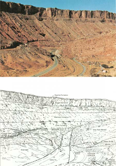
The junction of the park road with U.S. Highway 163 is shown at the lower left of figure 23, and the entrance station, Visitor Center, parking lot, and several buildings are seen at the lower right. Several residences for park personnel and other buildings are shown in figure 25. As shown in the lower part of figure 23, the geology at the park entrance is rather complex, as the park boundary here is partly along the Moab fault and partly along a branch fault—both in the Seven Mile—Moab Valley anticline (fig. 7). The Moab fault extends northwestward from Moab for more than 30 miles (McKnight, 1940, p. 120, 121, pl. 1).
As shown in figure 23, soon after leaving the checking station the park road begins to ascend the first of several switchbacks, and cuts first into the Slick Rock Member, then the Dewey Bridge Member, and finally the Navajo Sandstone the rest of the way to and beyond the top of the hill.
|
| FAULTED SEVEN MILE—MOAB VALLEY ANTICLINE. Top, View toward the southwest from park road about 1 mile above entrance station. Bottom, Geologic interpretation of photograph in part after McKnight (1940, pl. 1). Moab fault and branch fault (both normal faults, fig. 6) unite just beyond ridge of Slick Rock Member. Total vertical displacement along both faults is about 2,500 feet. H.F., unnamed upper member of Hermosa Formation; M.F., Moenkopi Formation; D, downthrown side of faults; U, upthrown side. Valley fill and slope wash of recent (Holocene) age obscure faults and underlying rocks. The original sequence of the rocks may be visualized by placing the Navajo Sandstone, the upper part of which is exposed at the lower right, on top of the Kayenta Formation, the lower few feet of which cap and protect the cliffs of Wingate Sandstone in the background. The Pacific Northwest (gas) Pipeline mentioned on page 15 is buried beneath the slice of the Moenkopi Formation between the two faults, which accounts for the disturbed appearance of the rock. (Fig. 23) |
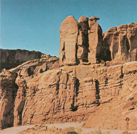
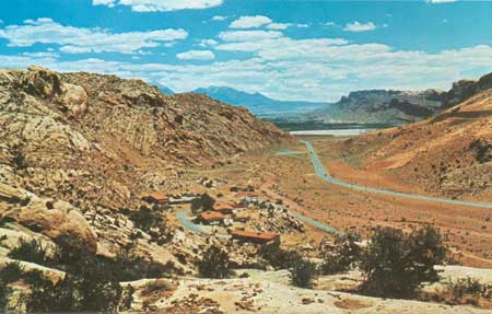
From points a mile or so up the hill may be seen interesting features in several directions.5 The view to the southwest is shown in figure 23, to the west are the Three Penguins (fig. 24). A good view of the Moab Valley is had by looking southeastward (fig. 25). A well in the Navajo Sandstone at the base of the hill supplies water to all the residences and to the Visitor Center, where a drinking fountain and modern restrooms are available to the public. Storage is provided by a steel tank hidden in a ravine above the buildings shown in figure 25.
5This is numbered stop 1 in the booklet referred to earlier "The Guide to an Auto Tour of Arches National Park," and corresponds to the numeral one on a small sign at the roadside parking place. Some of the other numbers are given in the pages that follow.
|
| THREE PENGUINS, viewed westward from park road about 1 mile above entrance station. Penguins are carved in massive Slick Rock Member seen resting upon thin-bedded Dewey Bridge Member. (Fig. 24) |
|
| MOAB VALLEY, viewed southeastward from park road about 1 mile above entrance station. Moab fault in about middle of valley, hidden beneath recent (Holocene) valley fill and slope wash, separates unnamed upper member of Hermosa Formation just above U.S. Highway 163 on right from Navajo Sandstone forming hills on left and ledges in foreground. Park Service residences at base of hill. White patch bordering Colorado River on northwest is tailings pile of Atlas Corporation's uranium mill. Moab and Spanish Valley are beyond river, and south end of La Sal Mountains forms distant skyline. (Fig. 25) |
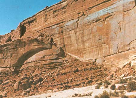
To the north the wall of Entrada Sandstone is cut by a normal fault (fig. 6), as shown in figure 26.
|
| FAULTED WALL OF ENTRADA SANDSTONE, north of park road A about 1 mile above entrance station. Fault is nearly vertical and normal (fig. 6), but fault trace slopes steeply downward to right, separating upthrown Slick Rock and Dewey Bridge Members on left from downthrown Slick Rock Member on right. Light-colored rock in foreground is Navajo Sandstone. Displacement probably does not exceed 50 feet. (Fig. 26) |
| <<< Previous | <<< Contents >>> | Next >>> |
bul/1393/sec10a.htm
Last Updated: 8-Jan-2007