
|
Geological Survey Bulletin 1393
The Geologic Story of Arches National Park |
A TRIP THROUGH THE PARK
Colorado River Canyon
THE SOUTHEASTERN BOUNDARY of the park for about 11 miles is the Colorado River, from the bridge on which U.S. Highway 163 crosses the river to a point upstream about half a mile below the mouth of Salt Wash. Illuminated night float trips down part of this reach are run during the summer, as noted on p. 16. Partly paved State Highway 128 follows the southeast side of the river for about 30 miles to Dewey Bridge, then goes northward about 15 miles to Cisco, where it connects with Highway I—70.
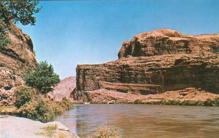
The rocks of the Glen Canyon Group form the southernmost corner of the park, as shown in figure 19. About 2 miles northeast of the bridge, we cross the axis of the Courthouse syncline (fig. 9), which brings the Navajo Sandstone down nearly to river level, as shown in figure 20. The underlying Kayenta Formation is largely hidden by vegetation and alluvial deposits in this view.
|
| GLEN CANYON GROUP, forming southernmost point of park, as viewed across the Colorado River from State Highway 128 half a mile above Moab bridge carrying U.S. Highway 163. Massive sandstone forming about the lower third of cliff is the Wingate Sandstone, darker thin-bedded sandstones and mudstones forming middle section of cliff comprise the Kayenta Formation, upper cliff is the lower part of the Navajo Sandstone. Note that the saltcedar (tamarisk), which lines both banks of the river, is in full bloom. (Fig. 19) |

|
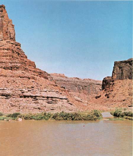
| NAVAJO SANDSTONE CLIFFS, bordering west bank of Colorado River in Courthouse syncline, from State Highway 128 about 2 miles above the Moab bridge. Note rounded domes at top of cliff. (Fig. 20) |
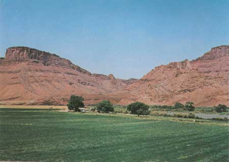
About 11 miles above the Moab bridge is the mouth of Salt Wash (fig. 1), as viewed from State Highway 128. (See fig. 21.) Seventeen miles above the bridge (east of area shown in fig. 1), we get an excellent view of the southeast end of the highly faulted Cache Valley anticline, as shown in figure 22. The background shown in the photograph formerly was the easternmost part of the former monument, but when the monument graduated to a park on November 16, 1971, this part of Cache Valley along with most of Dry Mesa was withdrawn from the park and put under the supervision of the Bureau of Land Management, also a part of the Department of the Interior.
|
| MOUTH OF SALT WASH, viewed across Colorado River from point on State Highway 128, 11 miles above Moab bridge. Dark cliffs on upper right and left are of Wingate Sandstone capped by thin protective cover of resistant sandstone beds of the Kayenta Formation. In background Wingate is overlain by entire Kayenta Formation and lower part of the Navajo Sandstone. Wingate is underlain to river level by weathered slope of the Chinle Formation. Water in Salt Wash is largely backwater from the bankfull river; actual flow in wash generally is much less but at times reaches flood proportions. (Fig. 21) |
|
| SOUTHEAST END OF FAULTED CACHE VALLEY ANTICLINE, viewed northwestward across Colorado River from a point on State Highway 128, 17 miles above Moab bridge. High cliff of Wingate Sandstone on left is capped by thin protective layer of the Kayenta Formation. About upper third of slope below base of cliff is the Chinle Formation, below which is the Moenkopi Formation extending to high-water level. Note bent and broken beds on right. (Fig. 22) |
As noted on page 16, part of "Run, Cougar, Run" was filmed just upstream from the irrigated field in the fore ground of figure 22, in a wide part of the valley called Professor Valley (fig. 7). This valley and the Richardson Amphitheater on the southeast side of the river were named after a Professor Richardson who settled in the area in the 1880's. The long abandoned townsite of Richardson was 1-1/4 miles due east from the point from which figure 22 was taken.
| <<< Previous | <<< Contents >>> | Next >>> |
bul/1393/sec10.htm
Last Updated: 8-Jan-2007