
|
Geological Survey Bulletin 1288
Surficial Geology of Mount Rainier National Park Washington |
TABLE OF CONTENTS
Surficial deposits record recent geological events
How surficial deposits are formed
Landslides, mudflows, and Mount Rainier's shape
Surficial deposits shown on the geologic map
Old drift
Hayden Creek Drift
Evans Creek Drift
Mudflow at Van Trump Park
McNeeley Drift
Rock-glacier deposits
Protalus ramparts
Mudflow at Paradise Park
Osceola Mudflow
Interbedded mudflows and alluvium
Burroughs Mountain Drift
Garda Drift
Bomb-bearing deposit in South Puyallup River valley
Mudflows
Taluses
Block-field deposits
Landslide deposits
Travertine
Alluvial cones
Alluvium
Avalanche deposits from Little Tahoma Peak
Perspective
ILLUSTRATIONS
PLATES
1. Surficial geology of Mount Rainier National Park, Washington (omitted from online edition)
FIGURES
Frontispiece Avalanche deposit of clay and debris on Tahoma Glacier
1. East side of Mount Rainier
2. Distribution of pumice deposits in Mount Rainier National Park
3. Recent pumice deposits on the floor of a cirque near Sluiskin Falls
4. Map of Mount Rainier National Park
5. Old drift on the north side of Glacier Basin
6. Bouldery till exposed in a gully on the north side of Glacier Basin
7. Hayden Creek till along the Mowich Lake road
8. Yellowish-orange rinds on stones of gray volcanic rocks
9. Extent of glaciers at Mount Rainier and in the adjacent mountains during the most recent major glaciation
10. Rock-glacier deposit at The Palisades
11. Protalus rampart on the north side of Sunrise Ridge
12. Pumice layer O underlies a yellowish-orange mudflow at Ricksecker Point
13. Osceola Mudflow exposed on the south bank of Inter Fork
14. Pumice layer C veneers a Burroughs Mountain moraine
15. End moraine of Garda Drift formed by Emmons Glacier
16. Breadcrust bomb
17. Mudflow from Mount Rainier on top of pumice layer Y from Mount St. Helens
18. Alluvial cone at the east base of Mount Wow
19. Avalanche deposit of rock debris from Little Tahoma Peak
TABLES
1. Characteristics, sources, and ages of pumice layers in Mount Rainier National Park
|
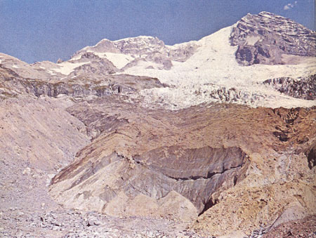
| AVALANCHE DEPOSIT of yellow-orange clay and rock debris lies on top of Tahoma Glacier on the west side of Mount Rainier. The avalanche originated in rockfalls at the cliffs at the upper left and slid down to the end of the glacier. The cliffs from the headwall of Sunset Amphitheater; Point Success is the peak at the right. The front of the glacier, in the foreground, is about 200 feet high. |
| <<< Previous | <<< Contents >>> | Next >>> |
bul/1288/contents.htm
Last Updated: 01-Mar-2005