
|
Geological Survey Bulletin 1288
Surficial Geology of Mount Rainier National Park Washington |
SURFICIAL DEPOSITS SHOWN ON THE GEOLOGIC MAP
OLD DRIFT
The age and extent of the glaciers responsible for the old drift are not known, but glaciers evidently covered this part of the Cascade Range very early in the development of Mount Rainier, perhaps even before the volcano first appeared. The old drift consists mostly of glacial deposits over lying bedrock formations that are older than Mount Rainier and underlying lava flows from the volcano. The lava flows are of a rock known as andesite,1 and they form many of the ridges that radiate from the base of the volcano, such as Mazama and Rampart Ridges and Burroughs Mountain. Each old drift deposit shown on the geologic map contains compact till, but some also include mudflows and rubbles of volcanic origin.
1Rock formations in Mount Rainier National Park are described in some of the reports listed at the end of the text.
Old drift exposed in a roadcut upslope from Narada Falls lies on a surface of glacially smoothed and scratched bedrock (fig. 4, locality 1). The till at this locality is overlain by a pumice-bearing deposit of sand and fine gravel that is interbedded with mudflows. This deposit, together with the till, is about 100 feet thick and is overlain by a lava flow from Mount Rainier that forms Mazama Ridge.
|
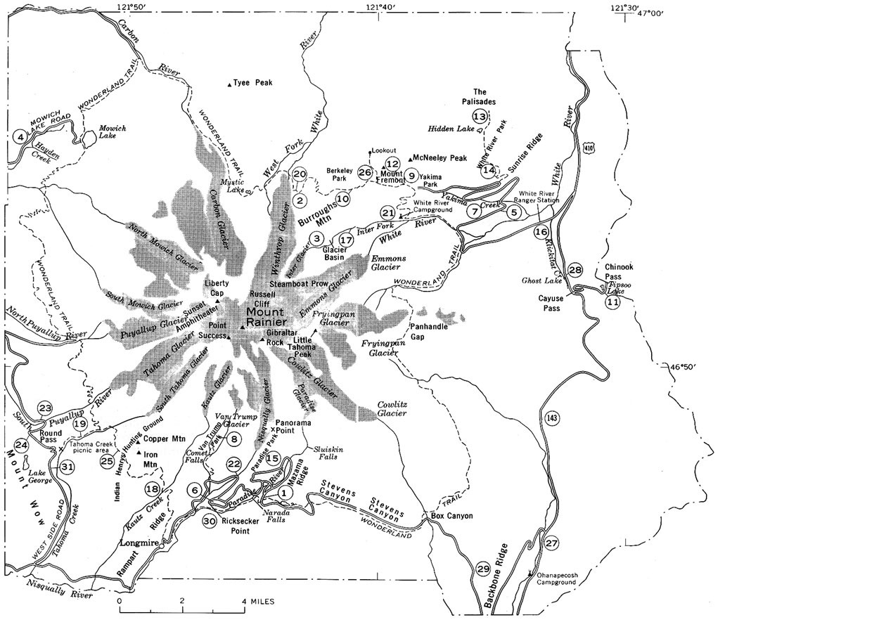
| MAP OF MOUNT RAINIER NATIONAL PARK, showing localities mentioned in test (numbered). (Fig. 4) (click on image for an enlargement in a new window) |
Old drift at the west end of Burroughs Mountain (fig. 4, locality 2) consists of about 800 feet of compact bouldery gray till and beds of sand and fine gravel. It is overlain, consecutively, by a deposit of loose gray and red volcanic rubble about 300 feet thick and by a lava flow from Mount Rainier. In Glacier Basin (fig. 4, locality 3) old till lies on top of compact mudflows and hard bedrock (fig. 5) . The till is very compact and bouldery (fig. 6) and is several hundred feet thick. Banked against it is an old lava flow from Mount Rainier, and both the till and the flow are over-lain, in turn, by a red volcanic rubble and a younger lava flow from Mount Rainier. The red rubble probably is part of the deposit that overlies the old drift at the west end of Burroughs Mountain. The old mudflows, the till, and the red rubble have been intruded by a wall-like andesite dike that forms a prominent ridge along the north side of Glacier Basin.
|
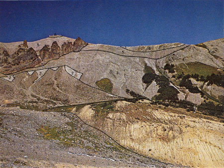
| OLD DRIFT on the north side of Glacier Basin. The geologic formations, in order of decreasing geologic age, are: 1, Bedrock much older than Mount Rainier; 2, mudflows which came from an old Mount Rainier volcano; 3, old drift, which consists mostly of very bouldery till; 4, an old andesite lava flow from Mount Rainier; 5, a red volcanic rubble from Mount Rainier; 6, a younger andesite lava flow from Mount Rainier; and 7, an andesite dike. The age relation of the dike to the younger lava flow is not known. The yellow deposit in the right foreground is a Garda moraine of Inter Glacier; it is about 200 feet high and consists almost wholly of Osceola Mudflow, which was eroded from the floor of the basin and redeposited by the glacier. The deposits in the left foreground and middle distance are alluvium younger than the moraine. (Fig. 5) |

|
| BOULDERY TILL exposed in a gully on the north side of Glacier Basin is part of the old drift. The boulders and smaller stones of various colors in the till are derived from the bedrock that underlies the volcano. The stones are contained in a very hard and compact matrix of brownish-gray silt and sand. (Fig. 6) |
| <<< Previous | <<< Contents >>> | Next >>> |
bul/1288/sec5.htm
Last Updated: 01-Mar-2005