|
Cowpens
Administrative History |

|
Chapter Seven:
RESOURCES MANAGEMENT AND PROTECTION AT COWPENS
Cultural Resources Management
The NPS has undertaken several inventory and planning efforts for cultural resources at Cowpens. In the 1970s, the Southeast Regional Office established an inventory of historic structures at the park through the List of Classified Structures (LCS) program. Park cultural resources on the LCS included the Robert Scruggs House, the Richard Scruggs House Ruin, the Green River Road, the U.S. Monument, and the Washington Light Infantry Monument. National Register of Historic Places documentation for Cowpens was prepared by the Southeast Regional Office in 1976 and approved by the National Register two years later. Contributing features included the Robert Scruggs House, the Green River Road, the U.S. Monument, and the Washington Light Infantry Monument. [1] A 1987 National Register of Historic Places amendment added the Richard Scruggs House Ruin as a contributing feature. The park prepared a resources management plan in 1984, finalized it the following year, and revised it in 1991. The University of Southern Mississippi began developing a geographical information system (GIS) in the mid-1990s as a management tool for the park's cultural and natural resources. The Southeast Regional Office supported this project as a GIS demonstration project for small parks in the region. [2]
Historic Structures
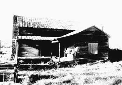
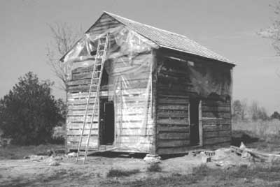
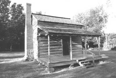
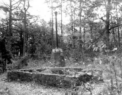
Of the eight historic residential structures identified during the planning process prior to the development of Cowpens, only two remained as part of the developed parkthe Robert Scruggs House and the Richard Scruggs House Ruin. The Robert Scruggs House was a log cabin built around 1830 and later enlarged with frame additions. NPS Historian Edwin C. Bearss documented the history of the structure and its significance in a 1974 historic structure report. As part of the park's development, the Scruggs House was restored to its original appearance between 1979 and 1980 by Moretti Construction, Inc., of Charlotte, North Carolina. [3] A local Boy Scout troop helped re-chink the Scruggs House in 1984, and park staff later performed other periodic re-chinking. In 1985 rotted elements of the rear porch were replaced with nonhistoric fabric in order to stabilize the structure adequately. By the early 1990s, significant deterioration threatened the Scruggs House. A 1991 historic structure assessment report by the Center for Architectural Conservation at the Georgia Institute of Technology detailed various structural problems. Two years later, park staff and the Historic Architecture Division in the Southeast Regional Office undertook a stabilization project that included replacing the roof, re-chinking with perma-chinking instead of the previous clay, and repairing deteriorated logs. [4] In addition to the Robert Scruggs House, the NPS preserved the Richard Scruggs House Ruin, the remains of a stone chimney from a historic house that burned during the 1950s. Stabilization of the chimney occurred around 1979. A local Boy Scout troop repaired the chimney's deteriorated mortar in 1984 and 1991, and the park filled in a well to the rear of the ruin in 1991. [5]
|
| Figure 29: The Scruggs House before restoration, 1977 |
|
| Figure 30: The Scruggs House during restoration, 1979 |
|
| Figure 31: The Scruggs House after restoration, 1999 |
|
| Figure 32: The Washington Light Infantry Monument in a deteriorated condition, 1975 |
Besides historic residences, the park manages two monuments. By the mid-1980s, the U.S. Monument had substantial leaching around the mortar joints, and its bronze plaques showed signs of oxidation. A 1986 cyclic maintenance funding request to address these problems was turned down. Lacking funds, the park cleaned the leaching stains with high-pressure water in 1985, 1987, and 1990. In addition, the plaques were cleaned and waxed. Staff from the Historic Architecture Division undertook limited mortar repairs in 1988, but the leaching continued. Using cyclic maintenance funds, the park contracted Masonry Stabilization Services Corporation to assess the condition of the U.S. Monument in 1992. The assessment report blamed the relocation of the monument, which had been cut into smaller pieces for the move, for creating the moisture problem that caused the leaching. Since the park lacked information on the monument's assembly and interior, the report recommended further research on the monument's construction before determining a final course of action. Two years later, staff from Vicksburg National Military Park assisted Cowpens with cleaning the monument and repairing its deteriorated mortar. However, leaching remains a serious problem awaiting a solution. [6]
As part of the development of Cowpens, the NPS restored the Washington Light Infantry Monument in 1980. The restoration involved a plaster coat over the concrete octagonal base. [7] By the mid-1980s, the park noted deterioration in the plaster and concrete at the monument's base. Although no work was undertaken on the monument at the time, park staff repaired the surrounding iron fence. The 1992 condition assessment for the U.S. Monument included the Washington Light Infantry Monument; restoration work was completed the following year. [8]
Another park resource that has required sensitive management is the Byars-Ezell Cemetery, the burial site of prominent locals like Nathan Byars and James H. Ezell. Containing several headstones and numerous unmarked graves, the small cemetery was cited by Bearss in his 1974 historic grounds and resource study for its significance to the local community. [9] Management of the cemetery has mostly involved reducing overgrowth with periodic maintenance. Due to fears of vandalism, the park placed the loose Nathan Byars headstone in museum storage after consultation with the regional curator in 1987. Four years later, Superintendent Armstrong met with Byars-Ezell descendants to discuss cooperative efforts to improve the cemetery's condition. Armstrong agreed to work towards having the park secure the Nathan Byars headstone in the cemetery and discussed other possible improvements. With little progress made on the cemetery by the late 1990s, the park was once again asked by descendants to improve the appearance of the cemetery and allow the placement of a new grave marker at the Nathan Byars grave. Superintendent Saunders made improvement of the Byars-Ezell Cemetery part of the park's five-year GPRA planning process and requested a two-year project for the cemetery. The first year would include a study of the historic appearance of the site, while the second year would involve restoration work. Besides suggesting that a new grave marker would harm the historic appearance of the cemetery, Saunders recommended waiting until a study was conducted before placing the headstone of Nathan Byars back at his grave. [10]
The Cultural Landscape
Besides historic structures, the initial development program at Cowpens focused on the restoration of the battlefield landscape to its 1781 appearance. Due to tree-growth rates, planners in the 1970s predicted that it would take ninety years to accomplish that process. The historic grounds and resource study by Bearss provided guidance on the elements that the restored landscape should incorporate. However, the only significant progress made on the issue during the 1970s was the removal of post-battle manmade features from the battlefield core. [11]
Throughout the 1980s and 1990s, sporadic landscape restoration work included the removal of exotic plants and other historically inappropriate vegetation. As trees and undergrowth were removed, the park planted hardwood seedlings in accordance with the recommendations in the 1974 historic grounds and resource study. However, the park lacked the funding to do any major landscape restoration. By the 1990s, the NPS was systematically surveying its historic landscapes with the Cultural Landscape Inventory (CLI) program. The CLI for Cowpens is currently underway along with a cultural landscape report, which will provide detailed information and management recommendations. [12]
An agricultural leasing program was another park initiative begun at Cowpens in March 1995. Due to the time and expensive equipment required to maintain the battlefield core area, the park began searching for alternatives. One such alternative was provided under the NPS's 1982 historic property leasing program. This program allowed Cowpens to lease around eighty acres at the battlefield to a local farmer for the production of hay. At first glance, the policy seems to contradict the basic notion of returning the park to its 1781 state, which was, after all, a grazing range. However, in the absence of cattle to control vegetation growth, and given the need to meet other park objectives, some active management of the landscape has been required. [13] For example, left to grow naturally, heavy underbrush interferes with visitor access and ease of interpretation. Among the issues that this policy raises are how to balance visitor expectations with park goals, how to meet park goals with funding limitations, and what landscape management methods are better or worse in light of these other issues. The current arrangement frees park maintenance staff from some mowing responsibilities and brings a few extra dollars for park projects. Because mechanical techniques used to control landscapes create their own problems, such as noise, spilled oil, and dust, the park may be funded in the future to use fire-management techniques to control underbrush and to reintroduce natural flora. [14]
Archeology
In addition to preserving above-ground cultural resources, Cowpens has undertaken a number of archeological investigations. For two main reasons these efforts have yielded only limited information on the battle. First, the brief event occurred in an open wooded area and left little in terms of physical remains. Second, the battlefield was heavily disturbed by post-battle developments, including farms, residences, and roads. [15]
Before the NPS began its archeological efforts at the battlefield, local farmers and souvenir hunters occasionally discovered minor artifacts like musket balls. For example, an ROTC class from nearby Wofford College combed the area with metal detectors in 1968, turning up five musket balls. Once the battlefield was acquired by the federal government, souvenir hunting was strictly forbidden. Park development activities sparked the first serious attempt by the NPS to deal with archeological issues at the battlefield. In compliance with national preservation laws regarding the use of federal property, much of this work coincided with the clearance of land for construction projects. For example, Southeast Archeological Center (SEAC) Archeologist John W. Walker undertook an investigation in 1974 of the sites for the proposed visitor center, parking lot, and entrance road. This effort resulted in no significant findings. [16]
The NPS also recognized the need for proactive investigations to uncover information for use in the park's interpretive programs. Both Bearss, in his 1974 historic grounds and resource study, and SEAC Chief Richard Faust, in a 1976 report, pointed out several archeological research topics. These included the "wolf pits" where British casualties were reportedly buried, Revolutionary War-era roads, the Richard Scruggs House Ruin, and the Byars-Ezell Cemetery. In 1979 Walker investigated the area around the chimney ruin of the Richard Scruggs House in order to ensure that proposed stabilization efforts would not harm archeological resources. In addition to concluding that the stabilization posed no harm, he recommended extensive test pit excavations at the house site. [17]
The archeological research issue that has been the primary focus at Cowpens is the location of the wolf pits, holes dug by Carolinian farmers to trap predators that were reportedly used as mass graves for American and British military casualties after the battle. [18] In his 1974 historic grounds and resource study, Bearss pointed out that an 1898 plat (an original U.S. Government-issued deed) included the location of the pits, but he was unable to locate the plat. Bearss recommended that further research be undertaken to discover the wolf pits for interpretive purposes. Although the tactics and events surrounding the battle are well understood, discovery of the graves would allow a more precise explanation of the battle and its participants and might possibly yield artifacts of significance to the park's interpretive program. British military historians would also benefit from an accounting of the fate of British troops lost during the battle. In 1987, with funding from ENPMA, the park used aerial photography in an attempt to locate the pits, but this effort proved unsuccessful. A major concern of Superintendent Saunders, efforts to locate the wolf pits intensified between 1995 and 1996. Donald Williams of the University of Southern Mississippi researched the pits and conducted metal detector surveys while compiling a geographic information system database for the park, but again, no new information was revealed. In late 1996, Jim Doolittle of the U.S. Department of Agriculture conducted ground penetrating radar testing in another inconclusive effort to locate the wolf pits. [19]
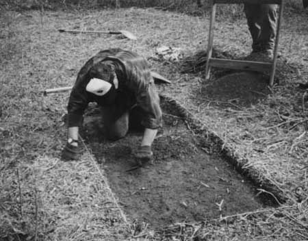
|
| Figure 33: A pit excavation during 1990s archeological work at Cowpens |
Collections Management
As evidenced by park interest in repeated failed efforts to find the wolf pits, physical remains tied to the Battle of Cowpens are scarce. The battle was fought without the creation of significant earthworks and was of short duration. Years of intense farming around the battle site before it became a national park have left little in the way of recoverable artifacts. Most items on display in the Cowpens visitor center are reproductions or period pieces related to the American Revolution, but not to the actual battle. Similarly, Scruggs House furnishings are reproductions or period pieces related to early nineteenth-century farm life. Even the portraits of battle commanders are reproductions of historical paintings obtained by other institutions long before the creation of the park.
The small curatorial collection at Cowpens was largely acquired to accompany the opening of the visitor center in 1981. The collection contains items such as musket balls, horseshoes, finials (flag pole ornaments), canteens, swords, and firearms. Typical items on display include a complete set of eighteenth-century American infantryman accoutrements and a British-made tin canteen acquired from the Harpers Ferry Center in August 1981. [20] Most of the park's archeological artifacts are stored at the Southeast Archeological Center; the rest of the museum objects are displayed or stored on site. A few items were collected from various archeological and natural resource surveys completed since the visitor center was commissioned and the most recent exhibits were designed in 1984, but these are not available for public viewing because of limited space and a lack of funds for new displays. Consequently, the park has occasionally sought ENPMA proceeds to fund new exhibits.
As suggested above, Cowpens has not had reason to focus upon collections oversight. Nevertheless, it still uses an orginial Scope of Collections Statement (1984), the baseline managerial plan that defines the scope of present and future museum collections and the relationship that objects must have to the site before they can be accessioned. The document provides basic guidance but needs updating to reflect revised legal mandates. The park also lacks a comprehensive collections management plan to guide day-to-day acquisitions and dispositions decision-making. However, in June 2000, a site visit was conducted by regional museum management staff to begin development of such a plan. [21]
One of the pitfalls in managing the park's museum collection, including its archival materials, is illustrated by a dispute in early 2001. The issue concerned the park's right to use the main painting commissioned for the visitor center, Charles McBarron's The Battle of Cowpens. After years of display and use of the painting on postcards and for other tasks, the park placed an image of the painting on its website and was promptly challenged by heirs to the artist's estate for copyright infringement. The McBarron painting was commissioned by the Harpers Ferry Center while Cowpens was administered under the jurisidiction of Kings Mountain, but neither of these organizations nor the park itself could produce original ownership documents for the painting. Apparently, these documents were purged by Harpers Ferry in accordance with National Records and Archives Administration disposition rules (as set forth in NPS-19, Appendix B). Under advice from the southeast regional solicitor's office, Cowpens then ceased use of the image until the issue was resolved. Eventually, Harpers Ferry did turn over sufficient documentation to establish clear NPS rights to the painting. As a result,Cowpens resumed use of the image, which is included on the cover of this report. Guidelines outlined in the forthcoming collections management plan should help park managers avoid similar future incidents. [22]
Natural Resources Management
Many of the natural resources management efforts at Cowpens have been focused on restoring the battlefield landscape to its 1781 appearance, with particular emphasis on the eradication of exotic plants, primarily Japanese honeysuckle and kudzu. During the early 1980s, the park's YCC enrollees removed various exotic species. In 1982 Uplands Field Research Laboratory of Gatlinburg, Tennessee, conducted a survey of exotic plants within the park and recommended several eradication options. In the years following the report, the park utilized local Boy Scout troops for exotic plant removal as part of merit badge projects. A 1994 project included spraying to control the growth of exotics. [23]
Besides exotics, the park occasionally removed dead or historically inappropriate trees. In the early 1980s, the park permitted locals to remove hay in areas on the periphery of the battlefield. During the mid-1980s, a peach orchid was cleared as were several dead trees, including numerous pine trees. The removal of these trees allowed for improved sunlight and moisture in wooded areas, which improved the health of the remaining trees. A mid-1990s pine bark beetle infestation resulted in numerous dead pine trees in the park. A January 1996 ice storm killed additional pines. Later that year, Foothills Forest Products of Union, South Carolina, salvaged the trees and paid fees direct to the federal government rather than the park, thereby leaving the park without funds for additional cleanup. [24]
Due to a lack of funding, the natural resources management program at Cowpens has undertaken only one inventory effort. Funded by ENPMA donations, a botanical survey was undertaken in 1997 by University of Southern Mississippi graduate student Cindy W. King. The survey inventoried 343 plant species within the park boundary and resulted in specimen collections at both the park and the university (although, as noted above, this collection has not been accessioned in park records). In addition, the Spartanburg Chapter of the Audubon Society conducted bird counts during 1996, but the park itself has not prepared a wildlife inventory. [25]
By the late 1990s, the air quality at Cowpens had become a potentially serious issue. Around 1990 the park allowed the South Carolina Department of Health and Environmental Control to place air quality monitoring equipment on park property. Information collected from the equipment by the state was reported to the NPS's Air Resources Division in Denver as part of the agency's gaseous air pollutant monitoring network. By 1998 this program included thirty-five parks across the nation that had the necessary equipment to monitor gaseous air pollutants like ozone and sulfur dioxide. According to the 1998 statistics, Cowpens had the eighth highest average ozone levels for both one-hour and eight-hour periods among the thirty-five parks. Probable reasons for the high ozone level at the Cowpens included a coal-burning power plant seven miles away and the traffic pollution from the I-85 corridor in the nearby Greenville-Spartanburg area. As a result of these statistics, park staff have become increasingly concerned about the impact of air pollution on the park's natural and cultural resources. [26]
Law Enforcement and Fire
Protection
Law enforcement was an early concern at Cowpens. During the years of park development, most law enforcement incidents involved vehicles trespassing on park property after operating hours or vandalism to park property, including the abandoned dwellings awaiting removal. For example, ten incidents were reported by park staff during 1978, including five for trespassing vehicles damaging park property, three for the burglar alarm at the temporary visitor center, one for thefts at two abandoned mobile homes, and one for an abandoned vehicle. To combat such vandalism, Robert E. Gentry became the park's first commissioned law enforcement ranger in 1978. [27]
Over the years, law enforcement incidents at Cowpens have generally been minor. The situation was summed up by Superintendent Stanek in 1982 when she stated that "all law enforcement activities at Cowpens will be a 'low key' type of enforcement situation where the officer maintains a firm but polite presence." [28] From the early 1980s through the late 1990s, the primary law enforcement problem at the park remained vandalism and thefts from vehicles. Just before the park's observance of the seventy-fifth anniversary of the NPS in 1991, one of the worst cases occurred when vandals damaged interpretive and traffic signs, a Scruggs House door and windows, and restrooms. Other incidents have involved such offenses as hunting on park property. Besides responding to such incidents, the park has undertaken proactive measures, such as a 1984 survey of park lands for cannabis by the University of Georgia School of Environmental Design. None was found. [29]
The law enforcement program at Cowpens has evolved over the past two decades. Since the 1970s, Cowpens has received assistance from the Cherokee County and Spartanburg County Sheriff's Departments. The jurisdiction issue was clarified in September 1983 when the NPS established concurrent jurisdiction allowing federal, state, and local authorities to share law enforcement duties as necessary at all five NPS units in South Carolina. As part of Superintendent Springer's effort to produce necessary park documents, a written policy statement for the law enforcement program was prepared in 1985. In 1991 the park's arrangement with the Cherokee County Sheriff's Department was formalized with the signing of a cooperative agreement. Since then, the county has provided general law enforcement needs at the park. Certain violations, however, such as archeological disturbances, still require specially certified NPS rangers. In such cases, Kings Mountain NMP provides support. [30]
In addition to cooperating with local law enforcement agencies, the park has built relationships with several volunteer fire departments and rescue squads. In 1984 the park and the Macedonia Volunteer Fire Department reached an understanding that the department would assist the park with any fires. In order to protect archeological resources, the fire department agreed to notify the park before bringing in heavy equipment to fight forest fires. This understanding was formalized in a 1991 cooperative agreement that included the Cherokee County EMS. In order to familiarize local firefighters with the battlefield, the park provided an orientation tour for local departments. Throughout its history, the park has also received special events assistance from other local fire and rescue agencies, including the Antioch Volunteer Fire Department, the Cherokee Creek Volunteer Fire Department, the Chesnee Fire Department, and the Chesnee Rescue Squad. [31]
| <<< Previous | <<< Contents >>> | Next >>> |
http://www.nps.gov/cowp/adhi/adhi7.htm
Last Updated: 10-Dec-2002