|
Casa Grande Ruins
Administrative History |

|
CHAPTER IV: CASA GRANDE RUINS AS A NATIONAL MONUMENT (continued)
C. The Development of Casa Grande Ruins National Monument (continued)
Returning to more mundane construction following the erection of the new ruins shelter, fiscal year 1933 brought several improvements to the monument grounds. A new one-eighth-mile service road was built and coated with road oil. In the spring of 1933 one-half mile of walkways were laid to connect the administration/museum building to the residences and Compound A. This walkway system was constructed of broken stone which was rolled and then sprayed with an asphalt compound to bind it together. Sand was sprinkled over it and worked into the surface by traffic. [29]
In May 1933, Thomas Vint mailed copies of the first Casa Grande "Master Plan" to Pinkley. The National Park Service field office in San Francisco had been working on the plan since mid-1932. It basically followed the ideas to which Pinkley and Vint had previously agreed. The plan called for considerably more construction than had been done to that date. To complete the monument housing needs, the plan proposed three more residences and a dormitory. It called for adding to the museum to finish it to Vint's original design of a square with an open center. The small, temporary pumphouse needed to be replaced. A maintenance area with three buildings was planned for the space just south of the residential quarters. During review, either Vint or Pinkley decided the proposed utility facility was too close to the residential area and, by using a pencil, drew a new location for two maintenance buildings farther to the south of the living quarters. Picnic area development included removing one ramada, extending the other existing ramada, adding four new ramadas, as well as building more fireplaces and tables (figure 23). The plan proposed that approximately two miles of old road and some old trails be covered to remove any trace of them. At the same time it called for the development of an informal footpath to follow a route from the Clan House to Compound C to Compound B to Compound E to Compound D and back to the parking lot by way of the south service road. Pinkley approved this Master Plan on September 2, 1933. He then developed a six-year program to accomplish the plan. At the same time the San Francisco field office issued a new Master Plan each year through 1941. Each new plan reflected the changes from the previous year (figures 24). Pinkley accomplished only part of what he wanted. By 1941 the Master Plan added proposals to change the design of the museum addition (figure 25). The plan also specified the need for digging a new well, obtaining natural gas by piping it into the monument, constructing an eight-stall garage, burying the electric line, building a brick incinerator, moving the east boundary fence inward to allow the state to construct better drainage along Highway 87, revegetating the area after the fence was set back, and establishing three interpretive trails to view various ruins instead of one long trail. [30]
1. Depression Era Programs
By fiscal year 1934 depression relief money began to be added to the Casa Grande budget, although by this point a large part of the construction program had taken place. Starting in September 1933, Public Works Administration (PWA) funds were used to replace the 3/4-inch water line with new 1-1/2-inch pipe, including hose valves, so that any building could be reached with a fifty-foot hose. The National Reemployment Service furnished local men to do the work. This same workforce installed a new hydrant at the picnic grounds. Two, 1,000 gallon water tanks were used to replace the two 525-gallon tanks installed in 1931. At the same time additional work was done on the picnic ground. More ramadas were added along with twenty new tables, seven fireplaces, and two swings and a teeter for children, while fifteen old tables were repainted. A Civil Works Administration (CWA) program provided men and money to bury the telephone line from the residential area to the monument boundary in December 1933. Civil Works Administration funds were used to purchase materials for the south and west boundary fences. Federal Emergency Relief Administration money paid the salary of six men in May 1934 to clear and grade that fence line in preparation for fence construction. The south fence was set back about thirty feet from the boundary to avoid silt dumped on the monument by the Indian Service from the Pima Lateral irrigation canal. Public Works Administration funds were also used to build one more residence. This final dwelling to be erected on the monument was begun in April 1934 and completed by July. At the same time the old quarters that Pinkley had built in Compound A in 1910 was repaired. It had stood empty from the time that Pinkley had vacated it in early 1932. [31]
Construction activity ceased for two years until 1936. In August of that year the Indian Service connected the monument to its power line. The line entered the monument from the south on poles until it reached an area several hundred feet south of the residential compound where, after leaving a transformer station, it connected to buildings by underground cable. By the end of 1936, the PWA supplied the money and manpower to construct a new sewer system. Work on that system began on December 19. It consisted of a new reinforced-concrete septic tank from which ran a three-inch concrete asbestos pipe for 1,600 feet southeast of the residential area. That pipe connected to a sixteen-nozzle sprinkler system which sprayed the effluent on the ground. The old cesspool was covered with concrete and became an overflow pit for the new system. [32]
In April 1937 Pinkley's old residence in Compound A was remodeled into an office for the Southwestern Monuments headquarters educational staff and quarters for two naturalists. When these men moved into the building in May 1937, they installed a homemade evaporative cooler. It was the first such cooling device to be used at the monument. The effectiveness of this "swamp cooler" resulted in a decision by Pinkley to install them in the other buildings. [33]
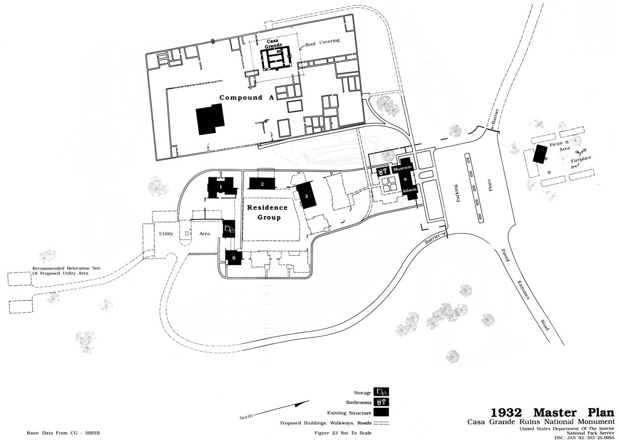
Figure 23: 1932 Master Plan map.
(click on the above image for an enlargement in a new window)

Figure 24: 1935 Master Plan map.
(click on the above image for an enlargement in a new window)
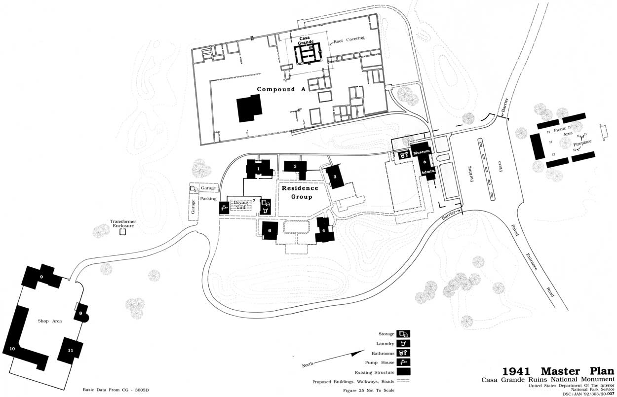
Figure 25: 1941 Master Plan map.
(click on the above image for an enlargement in a new window)
| <<< Previous | <<< Contents >>> | Next >>> |
cagr/adhi/adhi4c.htm
Last Updated: 22-Jan-2002