UAS go by a variety of names: umanned aircraft systems (UAS), remotely piloted vehicles (RPV), drones, unmanned aircraft (UA), uncommanded aerial vehicles (UCAVs), etc. Regardless, UAS are considered to be "aircraft" as defined by the Federal Aviation Administration (FAA) in 14 CFR Part 1.
On June 19, 2014, National Park Service Director Jonathan B. Jarvis signed Policy Memorandum 14–05, Unmanned Aircraft – Interim Policy. Its purpose was “to ensure that the use of unmanned aircraft is addressed in a consistent manner by the NPS before a significant level of such use occurs within the National Park System.”
This policy is still in force in many national parks - know before you go.
In addition to the director’s memo, which restricts takeoffs and landings in national park units all across the country, the FAA has also declared a “No Drone Zone” within a 15-mile radius of Ronald Reagan Washington National Airport.
Department of the Interior Policy on Unmanned Aircraft
Operational Procedures Memorandum-11, DOI Use of Unmanned Aircraft Systems (UAS) outlines Department of the Interior policy regarding the operation and management of UAS.
Department of the Interior Privacy Impact Assessment (PIA) identifies and addresses privacy implications for the use of UAS, particularly surveillance, image and video capabilities. This PIA covers the general use of UAS as authorized by the Office of Aviation Services in accordance with Federal and Departmental policy.
Unmanned Aircraft and Fire Management Activities
If you fly, we can’t! Use of unmanned aircraft by members of the public in the vicinity of active fires can negatively affect the safety of firefighters, pilots, and the public. The National Park Service and other federal land management agencies ask the public not to use these aircraft around wildland fires.
Over the past several years, there has been a rise in the number of public use of UAS on U.S. Forest Service and other non-NPS wildfire incidents that has grounded firefighting aircraft at critical times due to safety concerns.
On June 26, 2015, the National Interagency Fire Center in Boise, Idaho released information related to firefighter safety as well as interference in wildfire suppression operations by unmanned aircraft.

NPS Photo
2015 Utilization: DOI Tests Unmanned Aircraft on Olympic National Park Wildfire
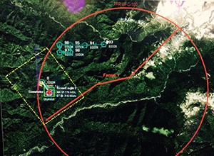
In late August 2015, an unmanned aircraft system (UAS) was utilized on the Paradise fire in Olympic National Park. The system was demonstrating possible applications in wildland fire management and suppression. UAS can supplement manned aircraft, especially at times of reduced visibility due to smoky conditions and at night when manned firefighting aircraft makes it difficult to fly.

Infrared Cameras
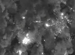
The primary goal of the UAS on the Paradise fire was to gather infrared information. This information assisted fire officials in pinpointing the fire’s perimeter and identifying areas of intense heat. The extremely large old growth trees in the area of the Paradise fire created a thick canopy that made mapping the perimeter and observing hotspots from the air very difficult without infrared capabilities.

NPS Photo
Exploring UAS use on Wildland Fires
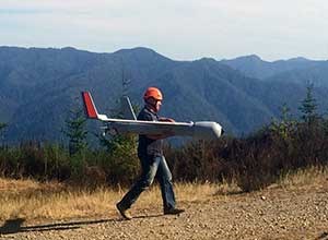
The operational demonstration had no direct cost to the government. It was one of a series of ongoing missions to further UAS use on wildland fire in national parks and is part of an interagency strategy for UAS integration into wildland fire support. The demonstration tested the capabilities and effectiveness of unmanned aircraft technology on wildland fires. The ScanEagle UAS that was flown on the Paradise Fire weighed approximately 50 pounds with a wingspan of 10.2 feet. The UAS was only operated within the Federal Aviation Administration (FAA) temporary flight restriction (TFR) area that was lifted after the testing.
The ultimate goal for UAS use on wildland fire is to supply incident management teams (IMT) with real-time data products, and information regarding fire size and growth, fire behavior, fuels, and areas of heat concentration. The Washington Department of Natural Resources (DNR) allowed the use of their land for the aircraft launch and recovery site. Additional applications, such as search and rescue and animal surveys, may be explored.
During busy summer fire seasons, such as the 2015 season, manned aviation resources are spread thin across the country and may be difficult to acquire. In addition to supplementing aerial resources, UAS are quieter than manned aircraft, use less fuel, and present a much lower risk to employees.
This was not the first UAS to be flown in the Olympic National Park. The park partnered with the U.S. Geological Survey in 2012 to monitor sediment transport in the Elwha River as part of the Elwha restoration project using a Raven UAS.
It is possible to picture a host of situations where rapid human deployment would be hindered by environmental conditions or simply deemed unreasonably hazardous, where use of real-time UAS imagery would prove invaluable to incident commanders. NPS works closely with the Department of the Interior to assist in the development of policy and guidelines for implementation of UAS activities.
Last updated: May 11, 2017
