
Six structures were identified during the 2010 field season and five were partially excavated. Archeologists used a wide variety of methods to investigate the L'Hermitage slave village site, including traditional excavation techniques and remote sensing. Nearly 200 shovel test pits (STPs) were excavated in a grid pattern; those test pits which contained concentrations of artifacts or archeological features were marked "high potential" for further research. Surface-penetrating radar (SPR) was also used to explore the site. This is a form of remote sensing which is particularly adept at locating underground foundations. When the unit is passed over the ground surface, its LCD display shows a graph of echoes. "Spikes" in the display indicate a possible archeological feature. Each of these "spikes" must then be ground-truthed to determine its archelogical value. The SPR survey helped archeologists identify two of the six structures. Once areas of archeological interest had been identified, archeologists began excavating 5 foot by 5 foot square excavation units (see map below). Each unit was carefully excavated layer by layer and screened. Careful notes and maps were made, and artifacts were collected. Eventually, a total of six structures were identified, five of which were partially excavated. Each structure consists of a stone chimney foundation with stone piers forming the corners of each building. Each building measured approximately 20 x 34 feet (680 square feet) and was probably constructed of log or frame. Numerous artifacts were uncovered, and a midden or trash pit was found in association with Structure B. Archeologists must analyze the artifacts and other data in order to interpret the site. The way that the slave quarters were constructed relative to the main house may help us learn more about the daily lives of the enslaved people. Click here to learn more about spatial hierarchy at the site. 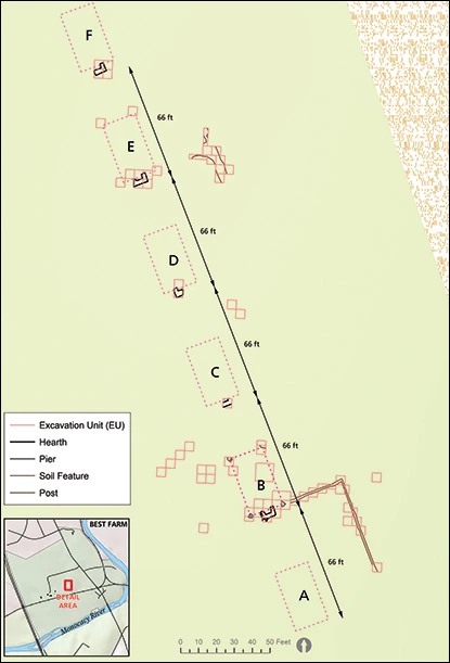
Structure B The southern-most structure excavated was designated Structure B. Shown below in plan view, it consists of a stone-and-mortar hearth centered on the southern elevation of the building, and two stone piers on either side of the hearth which define an approximately 20-foot wide structure. Other post holes were noted on the north elevation, creating a building footprint of roughly 20 feet by 34 feet. To the west of the structure, a midden or trash pit was identified containing a variety of architectural, domestic, and food remains. The other four structures excavated were similarly constructed. 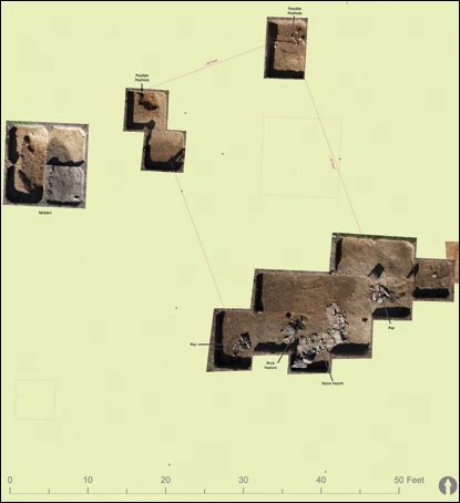
From top left, midden may be seen as an oval stain within the block of four excavation units; top center along north side of structure are two post holes; and bottom right, the extensive excavations reveal two stone piers on either side of a stone-and-mortar hearth. |
Last updated: June 9, 2020