Mount Baldy Dune Investigation

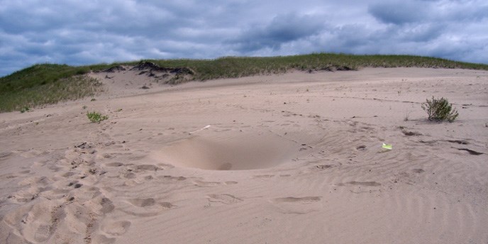
Mount Baldy Hole
Hole found on top of Mount Baldy.

NPS Collection


Brief summary of 2013 EPA Investigation

A recent investigation by the United States Environmental Protection Agency (EPA) concerning the development of depressions and open holes in the Mt. Baldy (dune) at Indiana Dunes National Lakeshore, a unit of the National Park Service, established that ground‐penetrating radar (GPR) is a viable tool to image the stratigraphy of the dune. Specifically, the geophysical technique was capable of imaging to a depth of ~30 ft and recognizing a buried soil horizon that was an exposed part of the dune in the middle of the 20th century. The study also plotted known depressions/holes, and these features appeared to align themselves with the relict, buried southeastern‐sloping slip face of the dune that was similarly exposed in the mid‐20th century. The current working hypothesis is that natural (trees and brush) or anthropogenic (structures or debris) materials were buried by the rapid landward movement of the dune during the late 1900s. The age of the materials and the wet conditions during the spring of 2013 may have forced these materials to become unstable, collapsing and creating openings to the surface.
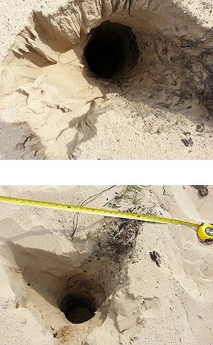

 
Mount Baldy Holes
Holes found on top of Mount Baldy.

NPS Collection

Proposed Next Steps:

  1. Repeat mapping of openings, depressions, and anomalous features.
  2. Understanding of the overall internal architecture of the dune, using multispectral GPR and coring.
  3. Detailed GPR in the areas of known subsidence accompanied with coring to target anomalies observed in the subsidence area.

Proposed Approach:

  1. National Park Service personnel (NPS) will periodically traverse the dune to recognize and locate, using a global positioning system, openings, depressions, and other anomalous features.
  2. The IGS and NPS will establish an approximately 750‐ft‐long longitudinal (offshore‐onshore) transect across the dune where 100 MHz and 250 MHz GPR will be collected by the IGS. Along this transect, continuous solid‐earth sediment cores (~15) will be collected using a GeoProbe with a dual tube sampling system. Cores will be collected at ~50 ft spacing and will extend 15 to 70 ft deep, depending on the subsurface geology and thickness of the dune. The spacing of the cores will be adjusted to accommodate observed surface and subsurface features along the GPR transect. Eight or more additional longitudinal GPR lines 250‐350 ft long will be collected at a transverse spacing of ~100 ft. The purpose of these additional transects will be to image the buried mid‐20th‐century slipface and proximal landward areas of the dune.
  3. IGS and NPS will collect 100 MHz and 250 MHz GPR data around a 30 m x 30 m (100 ft x 100 ft) longitudinal and transverse grid centered around the subsidence incident location. Five or more GeoProbe cores will be collected, targeting anomalies observed in the GPR grid. All cores will be returned to the IGS to be split and described to recognize sedimentary facies and subsurface materials that may produce the openings. If needed, grain‐size analyses will be conducted to establish and characterize facies. Up to five optically stimulated luminescence (OSL) age determinations will be measured with a similar number of radiocarbon dates. Cross‐sections will be created from the GPR transects and GeoProbemcores to establish the internal arrangement of the dune and the relationship of the openings and anomalies to the dunes stratigraphy and subsurface features.
 
Visit our keyboard shortcuts docs for details
Duration:
54 seconds

Discovering soft spots and holes located on top of Mount Baldy.


Primary Investigators:

Todd Thompson, PhD
Assistant Director for Research
Indiana Geological Survey, Indiana University
611 North Walnut Grove
Bloomington, IN 47405

G. William Monaghan, PhD
Geologist and Geoarchaeologist
Glenn A. Black Laboratory of Archaeology, Indiana University
423 North Fess Street
Bloomington, IN 47405

Erin Argyilan, PhD
Associate Professor of Geosciences
Indiana University Northwest
3400 Broadway
Gary, IN 46408

Charles Morris, PhD
Environmental Protection Specialist
National Park Service, Indiana Dunes National Lakeshore
1100 North Mineral Springs Road
Porter, IN 46304

Last updated: September 13, 2021

Park footer

Contact Info

Mailing Address:

1100 North Mineral Springs Road
Porter, IN 46304

Phone:

219 395-1882
Indiana Dunes Visitor Center phone number.

Contact Us