NPS Photo / Stephanie Martin
Overview
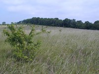
Boundless prairie and majestic oak savannas characterized the landscape that early settlers found in this area of the Midwest at Wilson's Creek National Battlefield. The landscape is part of the James River Oak Savanna/Woodland land type association within the Springfield Plain Subsection of the Ozark Highlands ecoregion. Much of the area was used as cropland in the past, and the remainder was used for grazing or forest products or both, so current vegetation represents plant communities in different stages of recovery from disturbance. Grasslands, including periodically mowed or burned open areas, cover roughly half of Wilson's Creek National Battlefield. Successional woodlands and forests cover the other half.The Wilson's Creek National Battlefield Vegetation Inventory Project delivers many geospatial and vegetation data products, including an in-depth project report discussing methods and results, which include descriptions to vegetation associations, field keys to vegetation associations, map classification, and map-class descriptions. The suite of products also includes a database of vegetation plots, and accuracy assessment (AA) sites; digital images of field sites; digital aerial imagery; digital maps; a contingency table listing AA results; and a geodatabase of vegetation, field sites (vegetation plots, and AA sites), aerial imagery, project boundary, and metadata.
Products
The products of vegetation mapping projects are stored and managed in the National Park Service's Data Store, a repository for documents and publications relating to park resources. From the highlighted items below, click on the type of information you are looking for.
Last updated: October 31, 2018
