The following information is summarized from the Northern Colorado Plateau Network monitoring plan, published in 2004. Some details may have changed.
Park History and Purpose
NPS
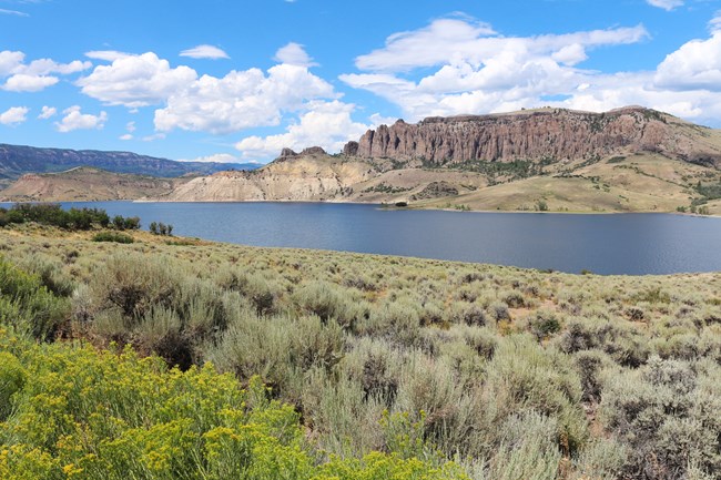
Curecanti National Recreation Area is administered by the National Park Service (NPS) through a February 11, 1965, Memorandum of Agreement between the NPS and the U.S. Bureau of Reclamation (BOR) and is part of the National Park System. The park is composed of a chain of three reservoirs impounded on the Gunnison River. The reservoirs comprise the Wayne N. Aspinall Unit (formerly the Curecanti Unit) of the Colorado River Storage Project, operated by the BOR. Curecanti draws its purpose from the 1965 Memorandum of Agreement and from the Colorado River Storage Project Act, Chapter 203, enacted April 11, 1956:
Sec. (1) “... the Secretary of the Interior is hereby authorized to construct, operate, and maintain the following initial units of the Colorado River Storage Project, consisting of dams, reservoirs, power plants, transmission facilities and appurtenant works;”
Sec. (8) “… the Secretary is authorized and directed to investigate, plan, operate and maintain (1) public recreational facilities on lands withdrawn or acquired for the development of said project or of said participating projects, to conserve the scenery, the natural, historic, and archeological objects, and the wildlife on said lands, and to provide for public use and enjoyment of the same and of the water areas created by these projects by such means as are consistent with the primary purposes of said projects; and (2) facilities to mitigate losses of, and improve conditions for, the propagation of fish and wildlife.”
Location
Curecanti National Recreation Area is located in Colorado’s Gunnison and Montrose counties, approximately 315 kilometers (196 miles) southwest of Denver, Colorado, and 24 kilometers (15 miles) west of Gunnison, Colorado.
Elevation
Elevations range from 1,981 meters (6,500 feet) at East Portal to 2,896 meters (9,500 feet) near Sheep Knob, in combination with slope, geology, and aspect, creating diverse habitats that support a wide variety of vertebrate and plant species.
Size
17,433 hectares (43,078 acres)
NPS/Sarah Karinen
General Description
The West Elk Mountains to the north, the Sawatch Range to the east, and the San Juan Mountains to the south frame the Gunnison River Valley. The modern Gunnison River was established in its current course 10–15 million years ago, just after the last eruptions in the San Juans and West Elks. This coincides with the beginning of rapid uplift of the Great Basin and Colorado Plateau provinces that lie between the Rockies and the Sierra Nevada Range in California. The uplift allowed the early Gunnison River to easily cut its way down through the thick layers of Tertiary volcanics and Mesozoic sedimentary rocks. Two million years ago, the river began to expose the much harder Precambrian basement rocks of the Gunnison Uplift. At the rate of about one inch per every hundred years, the Gunnison slowly worked its way through resistant rock, forming the narrow, steep-sided Black Canyon of the Gunnison. The volcanic deposits have since eroded on the mesa faces surrounding Blue Mesa Reservoir, forming spires and pinnacles as seen on Dillon Mesa. The towering canyon walls are an imposing feature of Morrow Point and Crystal Reservoirs. Morrow Point’s Curecanti Needle, sculpted from the canyon wall, stands as an excellent example of North American Precambrian bedrock.
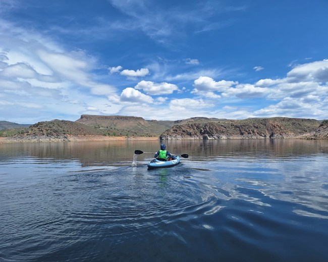
Blue Mesa Reservoir, one of three reservoirs and the largest body of water entirely within Colorado, is situated in the Gunnison River Valley. It borders steep bluffs and high mesas. Blue Mesa supports the largest kokanee salmon (Oncorhynchus nerka) fishery in the United States.Temperatures range from a low of -30°F (-34°C) in the winter to highs of approximately 85°F (29°C) in the summer. Average annual precipitation is approximately 280 millimeters (11 inches). Most precipitation occurs in spring and summer rains. The wind is predominantly from the southwest, with episodes of high velocity. Canyon bottoms are typically 10–15°F (5–8°C) warmer than rimtops during summer months.
Plants and Animals
Visitors may encounter a wide range of native and nonnative plant and animal species throughout the site.
Flora
The shoreline slopes surrounding Blue Mesa Reservoir are covered with grasses, big sagebrush, rabbitbrush, and Gambel oak, gradually reaching 2,743-meter (9,000-foot) mesas. The mesa tops are characteristically covered with high desert vegetation, with intermittent pockets of Douglas-fir, quaking aspen, and spruce. Separating the mesa tops are north–south-running canyons that contain lush riparian flora. Morrow Point and Crystal reservoirs, both narrow, fjord-like lakes, are situated in the Black Canyon of the Gunnison River. Shrubs and conifers cover the north-facing slopes and canyon rims along both of these lower, narrow reservoirs. Located within the park boundary are 18 kilometers (11 miles) of the Gunnison River and 85 kilometers (53 miles) of tributary streams.
NPS
Fauna
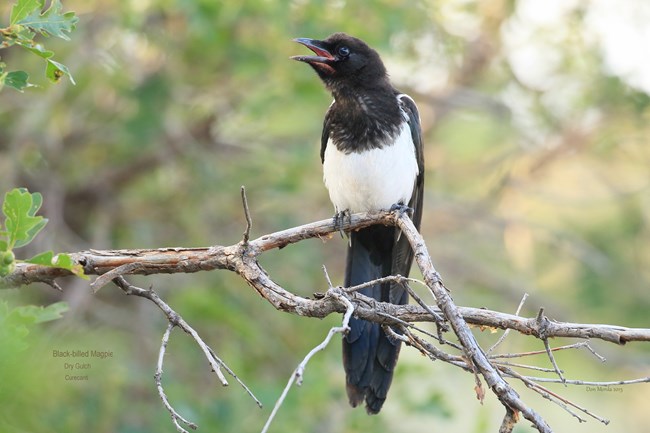
About 60 species of mammals and over 270 species of birds make up the base of Curecanti's wildlife resource. Some are permanent residents. Others use the park as a wintering ground or are migratory in nature.
Aquatic Features
The Upper Gunnison River watershed, upstream of the park’s western boundary, drains approximately 3,965 square miles. Located within the boundary are approximately 18 kilometers (11 miles) of the Gunnison River and 85 kilometers (53 miles) of tributary streams. The easternmost portion of the park comprises a riverine system, essentially unaltered since reservoir construction. This historic system encompasses an alluvial floodplain and is prone to natural flood events and channel avulsions. This diverse riparian area harbors a mature cottonwood (Populus angustifolia) overstory with an herbaceous understory.
Numerous ephemeral pools and wetland areas adjoin the river and harbor a diverse assemblage of vertebrate and invertebrate fauna. The Gunnison River, providing 50% of the inflow to Blue Mesa Reservoir, is of good quality and supports both native and stocked trout fisheries. Many high mountain streams, which form tributaries that enter Curecanti's reservoirs, originate from areas where the stream water quality is excellent. Many of these streams are relict and support high-quality, functioning aquatic systems. The effects of past mining activity, naturally occurring mineral contamination, grazing, logging, road construction, and recreational activities have degraded several streams in the upper portion of the basin. As these waters progress downstream toward Blue Mesa Reservoir, additional factors—including point and non-point sources such as municipal and industrial discharges, domestic sewage discharges, irrigation diversions, overland agricultural runoff, and gravel mining and stream channelization—have the potential to alter their quality. Some tributaries inside the park that flow into Blue Mesa, Morrow Point, and Crystal reservoirs were identified as potential sites for reintroduction of Colorado River cutthroat trout. The Nature Conservancy has identified several other tributaries as potential relict sites for inclusion as research natural areas. Blue Creek was noted as having significantly secluded and riparian attributes and requires further research.
Unique Features and Species of Special Concern
Curecanti National Recreation Area lies in the heart of one of the most scenic areas of the central Rockies, well known for its wide vistas and views of distant peaks. The surrounding natural environment provided rich hunting and food gathering for the prehistoric peoples of the Gunnison area. The abundance of wildlife, natural beauty, and diversity of recreational opportunities draws people today.
Plants and Vegetation Communities
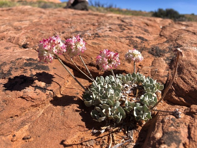
The park’s diverse vegetative resources include native and exotic species, irrigated meadowlands, and site-specific landscaped zones. This vegetation provides an opportunity for visitors to understand, experience, and enjoy the scenic and natural vegetative resources of the western slope of the Rocky Mountains. Four rare plants are either known or suspected to occupy lands within Curecanti, including Gilia pentstemonoides (Black Canyon gilia), Sullivantia hapemanii var. purpusii (hanging garden sullivantia), Astragalus microcymbus (skiff milkvetch), and Astragalus anisus (Gunnison milkvetch). Unique geological conditions and semi-arid environments combine to create a number of habitats of particular interest, including seeps, springs, riparian areas, and hanging gardens.
NPS
Animals
The park’s geographic location, along with the resources it offers, makes it an attractive site for a number of sensitive and rare wildlife species. Bald eagles, osprey, and an occasional whooping crane employ the riparian features during periods of migration. A great blue heron rookery occurs in the riparian habitat found in the eastern portions, and it is suspected that the southwestern willow flycatcher uses riparian features. Peregrine falcons nest on the cliffs. Western burrowing owls have been documented using prairie dog burrows within the abandoned hay meadows that make up the east-central portion. The Gunnison sage grouse, a recently recognized species, uses the sagebrush habitats within and surrounding the park to meet their year-round habitat needs.
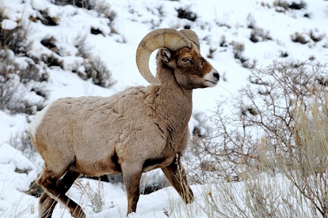
Curecanti supports populations of large mammals including elk, mule deer, bighorn sheep, mountain lion, black bear, and coyote.
Prior to impoundment, the area flooded by Blue Mesa Reservoir was one of the main wintering grounds for elk, mule deer, and bighorn sheep. Since impoundment, the entire bottomland and associated forage have been lost, and the seasonal migration of these animals has been restricted. Elk and deer presently use the north shore of Blue Mesa Reservoir during the winter, where as many as 1,200 elk in several herds have been observed.
The Gunnison prairie dog is an abundant species that uses open grasslands around Blue Mesa Reservoir. Regionally, there is concern about the status of this species because of continued habitat loss. The Black Canyon of the Gunnison provides excellent habitat for bats, but little is known about the status of bats at Curecanti.
Although water impoundments in the Curecanti project have altered fish propagation, a fish management and stocking program on Blue Mesa has increased the valuable fishing resource and contributed to fishing activities throughout the region. Currently, kokanee salmon and four varieties of trout, including brook trout, rainbow trout, brown trout, and Mackinaw trout, provide fishermen of the Gunnison River, the three reservoirs, and the many side streams with high-quality fishing.
Resource Management Concerns
Livestock Grazing
Livestock production and irrigated farming have been a way of life since the mid-nineteenth century. The principal use of land surrounding Curecanti National Recreation Area continues to be livestock grazing. Recurring problems are developing between grazing and wildlife habitat and recreational use—such as camping, picnicking, shoreline fishing, and hiking. These problems are associated with stock driveways, timing of seasonal grazing use, stocking levels, and inadequate fencing. Lack of fencing has resulted in livestock trampling of riparian vegetation, soil compaction, and streambank erosion. Livestock grazing may be affecting habitat for Gunnison sage grouse, elk, mule deer, and bighorn sheep.
Exotic Plants and Animals
Exotic plant species are invading both disturbed and undisturbed areas, displacing native species. Exotic vascular plants of particular concern include cheatgrass (Bromus tectorum), Canada thistle (Cirsium arvense), bull thistle (Cirsium vulgare), musk thistle (Carduus nutans), Russian knapweed (Centaurea repens), spotted knapweed (Centaurea maculosa), hoary cress (Cardaria draba), perennial pepperweed (Lepidium latifolium), yellow toadflax (Linaria vulgaris), common mullein (Verbascum thapsus), black henbane (Hyoscyamus niger), and tamarisk (Tamarix ramosissima).
While the introduction of exotic fish species into the stream and reservoir system created within the recreation area has increased the valuable fishing resource from a sport fishery standpoint, it has also impacted native species. The native fish species of particular concern is the Colorado River cutthroat trout (Oncorhynchus clarki pleuriticus), which still occupies some headwater streams that feed the recreation area.
Land Use Conversion
Increased near-park development is having visual and biological impacts on resources. Habitat loss as a result of Blue Mesa Reservoir and other adjacent development has affected Gunnison sage grouse, Gunnison prairie dogs, elk, deer, and bighorn sheep, as well as numerous other species in the
NPS/Kat Connelly
Visitor Use
Increasing visitor use through the 1980s and into the 1990s contributed to direct impacts to soil and vegetative resources, which have indirect effects on sensitive habitats and wildlife species.
Altered Hydrologic Regime
Construction of dams and water diversions and the destruction of riparian habitat have altered streamflow patterns, temperature regime, fish spawning habitat, fish species, and fish-food organisms on the Gunnison River.
Past Fire Exclusion
The natural systems within and surrounding the park have evolved with fire. The presence or absence of natural fire within a given habitat is one of the ecological factors contributing to the perpetuation of plants and animals in that habitat. Fire suppression has contributed to an alteration of plant communities.
Content was edited and formatted by E. Rendleman.
Last updated: June 27, 2025
