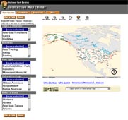
Park Locator Help
The Park Locator enables users to search for and identify park(s) of interest and navigate to either ParkNet or the Atlas application for that park unit. This application includes a basic collection of nationwide map layers that assist you in the identification and location for any park in the national park system. In addition, several reference layers of increasing detail (e.g. administrative boundaries, urban areas, highways, lakes and rivers) are available as you narrow your geographical search.
Basic functionality's for the Park Locator application includes zoom in, zoom out, zoom to full extent, pan map, identify features, and measure distances. The user can also use the identify function to click on a national park and view appropriate information about that park in a popup window and access a direct link to the web page (i.e. park profile) for that national park.
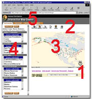
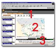
IMC Park Locator Layout
- Park Dropdown List
- Tool Bar
- Map
- Pick Lists (see first example)
- Menu Bar
Examples of Park Locator Use
Search Parks By Topics / Interests , Activities, Park Type, Cultural Heritage, and/or State
- Select Topic,(s) Activity,(s) Type(s), Cultural Heritage(s), and/or State(s) from the lists.
- Click on "Find A Park" button.
- A Map will be displayed with search results.
- Also list of parks will be displayed in the bottom window.
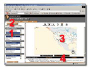
Select park with the Pull-down list
- Click on "Select a Park to View in Park Atlas"
- Click on the park you are interested in viewing
- You will be switched to the Park Atlas zoomed into a view for that park with a link to ParkNet's web page
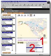
Select park using the Identify tool
- Click on Identify tool
- Click on the park of interest
- The text area will display information and links to ParkNet and Park Atlas
| US Department of the Interior | FOIA | Privacy Policy | Disclaimer | USA.gov |