|
Although the Brooks Range was well known to the Inupiaq and Athabascan peoples who trekked through the region in pursuit of fish and game, the mountains remained unknown to outsiders until the last decades of the 1800s. Long after the United States purchased Alaska from Russia in 1867, the Brooks Range remained a blank spot on cartographers' maps. During the 1880s, however, officials in the United States government felt the need to map northern Alaska, if only to know more about the vast territory under their jurisdiction. The first explorers to find their way to Alaska’s Interior – Lieutenant Frederick Schwatka and Lieutenant Henry Allen, both of the U.S. Army – mapped major waterways in Interior Alaska but did not reach far enough north to encounter the Brooks Range. Lt. Schwatka charted much of the Yukon River, and although Lt. Allen did not cross what is today the boundary of Gates of the Arctic National Park and Preserve, at the end of his 1,500 mile journey he did manage to map the upper course and tributaries of the Koyukuk River based on information from a Koyukon Indian elder. These early attempts soon inspired others to investigate Alaska’s last terra incognita. 
Alaska State Library Between 1883 and 1886, officers of the U.S. Navy and the Revenue Marine Service (now the Coast Guard) began investigating the rivers emptying into the ocean at Kotzebue Sound in northwestern Alaska. Although cooperation between the military branches was the norm, a rivalry developed between Naval Lieutenant George Stoney and Captain Michael Healy of the Revenue Marine after both men gathered geographical information from coastal Natives about the extent of the Noatak and Kobuk Rivers. In 1884, Stoney and Healy (with Third Lt. J.C. Cantwell as his proxy) each launched their own expeditions up the Kobuk River, gathering mineral samples and describing Native peoples as they traveled. For the next two years, each of the expeditionary parties tried repeatedly to outdo the other by advancing further upstream and claiming the right of first discovery. In addition to gathering basic geographic and ethnographic data, both Stoney and Healy hoped to find a route north across the Brooks Range to allow rescue expeditions to help ice-bound whaling crews on the Arctic coast. Travel above the Arctic Circle is frequently arduous, and these military explorers faced more than their share of hardship. To begin, they were fighting against the current in major rivers, nursing along either steam launches that broke down regularly or the Native skin boats known as umiaks which needed frequent patching. They faced high water, low water, low rations, rapids, capsizing, constant cold and wet, and devilish swarms of biting flies and mosquitoes. They spent endless hours waist deep in the freezing water with straps around their shoulders, pulling against the current or portaging over swampy land. This is how J.C. Cantwell described his crew after one overland journey: They had been drenched by the rain and tormented by the mosquitoes ever since leaving the river, and their condition was now really pitiable. Their boots had been worn out by hard walking, and they were compelled to cut pieces from their blankets to bind around their feet. Their clothes were torn and their faces, haggard and blood-stained. 
UAA, Archives & Manuscripts Dept. Unsatisfied with only being able to travel in summer, Stoney equipped his crew with provisions for a twenty-month overwintering expedition at a site they called Fort Cosmos, some 250 miles up the Kobuk River. From this base near the modern village of Shungnak, Stoney sent men in all directions with orders to map and gather intelligence. Stoney’s own description of the journey includes this description of the spectacular Arrigetch Peaks (located in the southwestern corner of Gates of the Arctic): They appear in every conceivable way and shape: there are rugged, weather-scarred peaks, lofty minarets, cathedral spires, high towers and rounded domes; with circular knobs, flat tops, sharp edges, serrated ridges and smooth backbones. These fantastic shapes form the summits of bare, perpendicular mountains. One of Stoney’s men, Ensign W.L. Howard, managed to lead a team of two military men and two Natives northward to the Noatak River and beyond to the Arctic Ocean near Point Barrow. Along the way, Howard and his white crewmates had to learn to live off the land and to follow the lead of the Natives in the region who included the men in their seasonal rounds to trade furs on the Arctic coast for seal oil, rifles, and flour. Howard learned to snowshoe and drive a dog team, to hunt caribou and build a snow shelter. The accounts written by Stoney and Healy (and some of their subordinates) provide a glimpse of interior Eskimo life at a critical juncture between traditional ways and the new ways brought by traders and whalers. By 1886, most of the Eskimo groups had been severely affected by the combination of caribou decline and the diseases and trade goods of the whites – particularly the introduction of the rifle, which altered traditional hunting patterns. Starvation, death from disease, and a desperate kind of mobility as people fought for survival and access to addictive trade goods had already disrupted normal seasonal rounds and wreaked havoc on Eskimo lifeways. 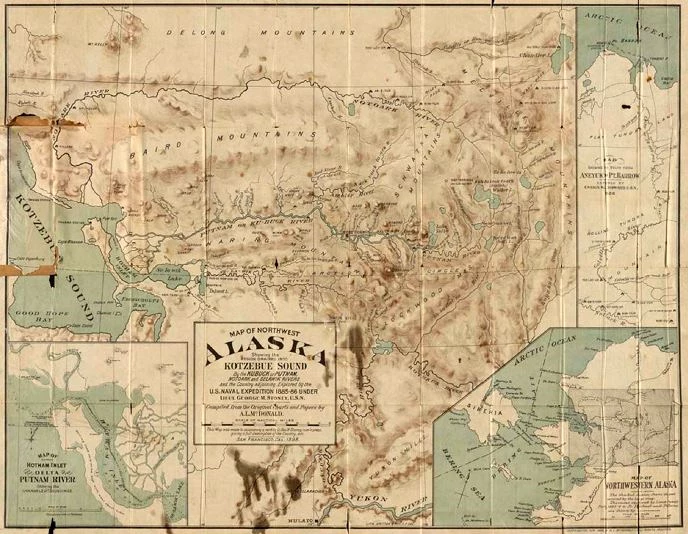
University of Alaska Fairbanks Library Rare Maps Collection These early journeys into the Brooks Range and Arctic Alaska opened the region to the outside world, to the prospectors spilling out of the Klondike in search of new gold fields and to still more map-makers, the dedicated geologists and cartographers of the United States Geological Survey. Even so, the remote Brooks Range with its ice-choked rivers and wind-blown mountain peaks seemed to offer little to an industrialized America. The people living on the land were widely dispersed, most towns sprang up only to fade away, and the land remained largely unaltered – that is, until the arrival of the airplane closed the distances and the discovery of oil on the North Slope attracted the world’s attention. Suggested Reading: The History of the Central Brooks Range, William E. Brown (2005) |
Last updated: December 19, 2025