
Montrose County Historical Society
WATER IS LIFE Water is life: a simple concept; but in the arid west, settlers could not rely on rain to supply water to nourish their fields. The community at East Portal brought together people of various skills and backgrounds to construct a tunnel that would transfer a portion of the Gunnison River water to the fields of the Uncompahgre Valley to the west. Their labors from 1905 to 1909 drove a tunnel 11 feet x 12 feet six miles through the cliffs of the Black Canyon and helped ensure the survival of communities in the valley.
Few governments in the history of the world have given away land to their citizens. The Homestead Act directed the U.S. Government to do just that in the years following the Civil War. As families moved into the valleys of western Colorado in the 1880s, they found the nearby streams to be unreliable sources of irrigation for their fields. Without water, the land held no value for them.

Uncompahgre Valley Water Users Association Plans to divert water from the Black Canyon’s more dependable Gunnison River were visionary. Beginning in 1894, surveys eventually revealed locations for both ends of a tunnel (in the canyon and the valley), with the intent of meeting in the middle. A road was scraped into the canyon slopes, descending to the river, and the town of East Portal (also known as River Portal) was born.

Denver Public Library Western History Collection
“The basis of our prosperity is our great agricultural productions, and the stability of our institutions depends upon the home owners. The home has ever been esteemed as the basis of the government. It is the great humanizer and civilizer of the world. Can anyone doubt the good sense policy advocated by this bill in lending to the home maker a few million to enable them to help themselves?”

Library of Congress The act charged Chief Engineer of the new Bureau of Reclamation, Frederick Newell, to proceed with building five projects: 1) Milk River in Montana, 2) Newlands or Truckee, Nevada, 3) North Platte, Wyoming, 4) the Salt River Project in Arizona, and 5) the Uncompahgre Project in western Colorado, whose best-known feature was the Gunnison Tunnel. Newell was among Roosevelt’s closest advisors on conservation.

Right, Abraham Lincoln Fellows 
The jovial Ira McConnell explored the depths of the canyon. He completed surveys that pinpointed the tunnel headings and towns of East Portal in the canyon, and Lujane (luh-WAH-nah) on the valley side of the tunnel. He guided tunnel construction through the most difficult of problems. Left, Ira McConnell 
A graduate of Cornell University, Herbert Daniels was the superintendent of the town of East Portal. Schooled in engineering, his steady hand on day-to-day matters kept construction on schedule, the tunnel on a straight course, and the town well supplied. Right, Herbert Daniels
CONNECTING THE DOTS 
Uncompahgre Valley Water Users Association 1892: THE DREAM The idea for a tunnel is credited to Frank Lauzon, a miner, prospecting in the mountains around Leadville, Colorado and Moab, Utah. By the early 1890s he was trying to succeed at farming in Montrose. A story is told that he had a dream. Worries of making ends meet plagued him, when, in a cold sweat, he fell asleep. It was then that he saw the waters of the Gunnison River brought to the valley.
While the waters of the Gunnison River were the most reliable in the area, the river had carved through the Gunnison Uplift, which rises 2,000 feet above the Uncompahgre (un-come-PAH-gray) Valley. This created a serious barrier for farmers wanting to reach the river’s waters.

Denver Public Library Western History Collection An onsite inspection trip of Black Canyon and the Gunnison River was organized in 1900 under John Pelton, farmer, miner, and head of the local land office. Members included surveyor John Curtis, farmers Erik Anderson and Frank Hovey, and youthful William Torrence, director of the local electric company. The unexplored canyon proved to be a great challenge. At a place called “The Narrows” they abandoned their quest and clawed their way to the rim. However, the trip focused state and national attention on the proposal, and support for it increased. 
Hydrologist Abraham Lincoln Fellows, on the right in the photograph, was telegrammed from Washington, D.C. to investigate the tunnel’s potential. He hired Torrence for a 9-day expedition in August, 1901. In the canyon the cliffs narrow to 40 feet. Fellows described The Narrows, “…we saw before us the mighty jaws, from which there was to be no escape, [and] a feeling of nervousness and dread came over me for the first time.” Their survey readings revealed the tunnel to be feasible.
1904: CHOOSING A SITE Initial plans for the tunnel placed it at The Narrows. Survey teams rushed over the rims of the canyon and braved troubles that challenged even the most hardy. An alternate site was eventually selected three miles upriver because the cost of construction was lower. 
Montrose County Historical Society Building the Road A writer for the Montrose Press recorded, “Every vehicle that goes to the River Portal is provided with an iron “shoe” that fastens on the back wheel and secured by a chain... With the wheel securely fastened...one’s hair stands on end as the horses start on a trot... so we shut our eyes, grapple the lines as tightly as possible, and trust to Providence that the vehicle will remain on the grade until a level spot is struck...” 
Montrose County Historical Society Residents of the growing town of East Portal originally lived in canvas tents. By 1906 it was a thriving community clutching the slopes of the canyon. While it never housed more than 250 people, it did provide a dining hall and bunkhouses for single men working around the clock in three shifts. Families lived in private cabins. Other services included a hospital, post office, general store, library, billiard hall, and school. Although they were isolated, they were not unaware of national events. Like many Colorado towns that raised relief money, they gathered $220.00 to help survivors of the San Francisco earthquake.
1906: TECHNOLOGICAL CHANGE Two advances in technology made work safer and easier. Jack hammers fed by a compressor replaced hand-turned drill bits to set holes for blasting charges. Dynamite replaced black powder for blasting. It was more stable, reliable, and reduced the number of injuries during the project. Construction began in January, 1905. By 1906 shifts of workers (up to 30 at a time) functioned like a well-oiled machine inside the tunnel. 
National Archives and Records Administration While digging continued on the tunnel, a massive effort was made to extend a system of ditches to carry the water to individual farm fields. The largest of these, the South Canal, would carry water from the tunnel to the Uncompahgre River. Workers used electric-powered trains to lug the carts full of debris out after blasting. Candles and lanterns were first used to light the work, but electric lights strung along lines improved visibility in the tunnel. 
Montrose County Historical Society
Methods of Digging To create a tunnel 12 feet tall, workers used a “heading and bench system.” They initially cut a “heading” out of the rock by starting at the top of the bore. They cut down 6 to 8 feet, leaving a bench of 7 to 5 feet on which to stand. Two drillers and a helper cut deeper into the rock while standing on the bench. The bench was eventually cut out, leaving the full 12-foot height of the tunnel. 
Montrose County Historical Society 
National Archives and Records Administration 1909: CULMINATION 
Memorial arches soared more than two stories high on Main Street in Montrose, welcoming people from around the country. Those attending the event sent postcards marking the dedication. Commemorative pins were proudly displayed in Montrose that fall. 1922: CONTINUING THE LEGACY

Lisa Lynch/NPS
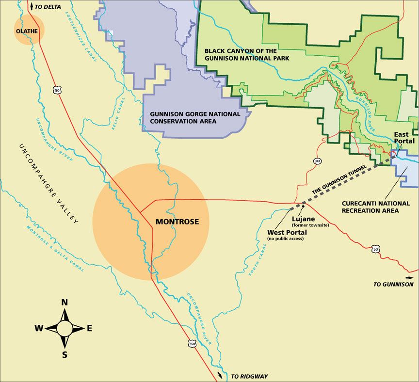
Irrigation water usually flows through the tunnel from April through October. Gravity causes the water to flow from West Portal through the South Canal to the Uncompahgre River. Like a central artery that branches out to capillaries, the river supplies six primary canals, such as the Montrose & Delta or Selig Canals. From these primary canals water flows into secondary ditches and eventually into farm fields. Today’s farmers have inherited a legacy of living close to the land, and remind us of America’s agricultural roots.
Historic Resources at East Portal All plants, animals, rocks and historic objects at Black Canyon and Curecanti are protected by federal law. Do not damage historic or natural features. If you find an artifact, please leave it in place. |
Last updated: February 24, 2015