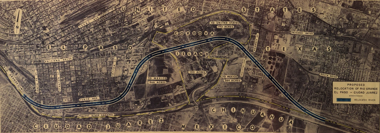
—Richard Fenner Burges, May El Paso Public Library As a naturally flowing river, the path of the Rio Grande was continually shifting through gradual processes of erosion and deposition as well as quick changes from flood waters suddenly carving out a new channel (known as avulsion). In the Convention of 1884, Mexico and the United States reaffirmed the river’s deepest channel as the international boundary. For the first time, the new treaty also acknowledged the river’s changing course. If the river channel moved gradually over time, the boundary moved with it. If the river shifted suddenly, the boundary remained along the previous course. By the 1890s, the Rio Grande made a dramatic bend that caused flooding in both El Paso and Ciudad Juarez. The International Boundary Commission placed 19 monuments around the perimeter of Cordova Island to mark the international boundary. During American Prohibition in the 1920s-30s, the area attracted drinkers and cross-border smugglers. In response, Mexico erected a fence along the perimeter in 1940. As US and Mexican negotiators drafted the terms of the Chamizal Convention, sketched the path of a new channel that would be a clear boundary with the United States to the north and Mexico to the south. Instead of following the boundary around Cordova Island, however, the straightened channel cut the area in half. The northern half was transferred to the United States, and an El Paso neighborhood further east was transferred to Mexico to compensate. 
University of Texas at El Paso Library Today, the part of Cordova Island now in the United States comprises Chamizal National Memorial, the Bridge of the Americas port of entry, and Bowie High School. |
Last updated: August 17, 2024
