|
You are viewing ARCHIVED content published online before January 20, 2025.
Please note that this content is NOT UPDATED, and links may not work. For current information,
visit https://www.nps.gov/aboutus/news/index.htm.

NPS photo
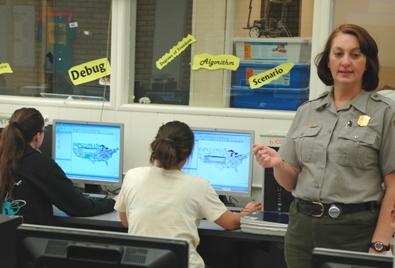
Contact: Paula Bauer In a time when budgets are tight for everyone, a situation in which all parties gained something without any additional funds being spent is heartening. In April, Susan Norman, Geographic Information Systems (GIS) specialist at Carlsbad Caverns National Park, accepted Dr. Jerry Cox's invitation to teach his science class at Carlsbad High School. "Specifically," Ms. Norman explained, "Dr. Cox asked me to present a general overview of GIS and the theory behind it using special software called Map Window GIS." In addition to the theoretical aspects, Ms. Norman described how this kind of technology and software has practical applications in a work place like Carlsbad Caverns National Park. In the park, she maps everything from natural resources, such as bird nests and cave locations, to man-made facilities, such as signs, trails, and fences. Park managers, then, use the maps and the relationships they reveal to care for resources and ensure visitor safety and enjoyment. When asked what they were learning about in Dr. Cox's environmental science class, students responded with a list that included, "ecosystems, renewable resources, animal migration, irrigation in the American West". To this list, they now add digital cartography. Dr. Cox described the hands-on lessons taught by Ms. Norman as, "an opportunity to expose the students to GIS and [map] layering in order to prepare them for college and advanced placement exams." While the students received practical training and experience in map making from an expert's real-world skills, the school met curriculum goals and the National Park Service fulfilled its educational mission. From the small investment of Ms. Norman's time and knowledge, the students made large gains in understanding the role of science and technology in the care of national parks and the natural and cultural resources protected within them. |
Last updated: February 24, 2015
