|
You are viewing ARCHIVED content published online before January 20, 2025.
Please note that this content is NOT UPDATED, and links may not work. For current information,
visit https://www.nps.gov/aboutus/news/index.htm.
NPS photo
Contact: Karen Bradford, Chief Ranger, 870/365-2740 The Buffalo River has receded sufficiently for canoe and kayak use to resume today. Although a comprehensive damage assessment is still ongoing, all campgrounds with the exception of Tyler Bend and parts of Buffalo Point are open. However, all are still soaked and most have varying amounts of mud, sand, or silt covering former grass surfaces. Roads throughout the park are open and grading operations under way, but visitors will find conditions variable, especially at water crossings and low-lying areas, and should exercise caution. Most toilet facilities are closed until vaults can be pumped and walls and floors cleaned.
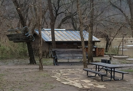
The trail at Lost Valley is open although some surfaces remain uneven. The river crossings in the Erbie area, in very bad condition prior to the flood, are impassible. This flood event ranks among the top five in recorded flood history of the Buffalo River. Damage in the upper district (roughly Boxley to Mt. Hersey) was light with little deposit of debris. Moving downriver impacts were greater as the accompanying photo showing picnic tables in trees at the Tyler Bend Campground. Furloughed park maintenance staff will be brought back to work on the clean up beginning January 10th. The good news is that the many waterfalls throughout the park are in full force while the runoff continues!
|
Last updated: February 27, 2016