|
You are viewing ARCHIVED content published online before January 20, 2025.
Please note that this content is NOT UPDATED, and links may not work. For current information,
visit https://www.nps.gov/aboutus/news/index.htm.
NPS photo
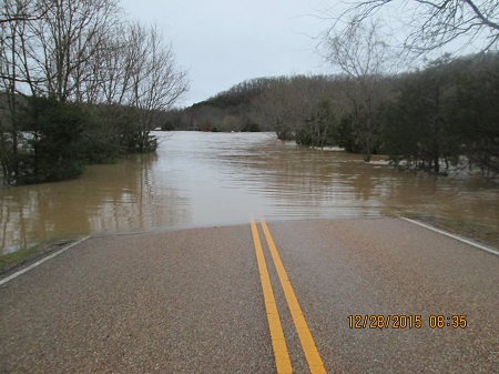
Contact: Karen Bradford, Chief Ranger, 870/365-2740 Shortly after7 am this morning the Superintendent closed Buffalo National River to river traffic due to flooding caused by the extended heavy rains over the weekend. At the time of this release river levels were continuing to rise in much of the park. The river crested in the Ponca area between1 and 2 amMonday which translates to an anticipated crest in the Tyler Bend area at about noon today. Predicted crest height may be as much as 47-50 feet.
First light found the entire Ponca put-in underwater. At Tyler Bend the entire campground was underwater which is currently reaching the base of the hill below the visitor center. Park staff are in the process of documenting impacts. Initial assessments show that flood water has inundated many of the campgrounds throughout the park. As of 9 am the Buffalo River was receding as far down as Carver. USGS gauging stations at Hwy 14 and Hwy 65 show the rise is slowing. By way of comparison USGS gauging stations showed approximately half the flow rate for the Buffalo at Hwy 14 as the Arkansas River has at Fort Smith, and the Arkansas river has risen about 15 feet and is in its floodplain. Lost Valley Road is open but Clark Creek is blocking access to the hiking trail. Visitors should be aware that while the closure does not pertain to roads and trails there are obvious safety concerns and visitation at this time is not advised. All creek crossings should be treated with caution. |
Last updated: February 27, 2016