An official website of the United States government
Here's how you know
Official websites use .gov A
.gov website belongs to an official government
organization in the United States.
Secure .gov websites use HTTPS A
lock (
) or https:// means you've safely connected to
the .gov website. Share sensitive information only on official,
secure websites.
Twin Arches and Twin Arches Loop
The Twin Arches are one of the most unusual and beautiful geologic features in the Big South Fork. The Arches themselves may be reached by hiking a short trail of seven tenths of a mile one way. The hike is easy to moderate with the exception of some very steep steps. Allow an hour for the round trip. The Twin Arches Loop is 4.5 miles long and includes some interesting rock overhangs (rock shelters) and cliffs, an old home site and the Charit Creek Lodge. The trail is moderate in difficulty and can be hiked in three to four hours. The Twin Arches trailhead is located on the western edge of the park off of Divide Road in Tennessee.
Slave Falls/Needle Arch
This short, easy hike includes a good view of a 60 foot waterfall as well as a natural arch. The hike is approximately 1.5 miles one way and can be done in about an hour. There may be very little water coming over the falls in late summer and fall but the hike is still worthwhile. To access Slave Falls use the Sawmill trailhead located on the western part of the park in Tennessee. Turn on Divide Road and travel one mile from Hwy 154. At the next intersection turn right on to Fork Ridge Road. Sawmill will be on your left just past the Middle Creek Equestrian trailhead.
Middle Creek Loop Trail
This easy trail is often overlooked. The trail winds through upland hardwood forest and past some beautiful rock shelters. The entire lop is 3.5 miles and takes about 2 hours to complete. A spur trail from Middle Creek Loop connects to Sawmill Trailhead and the Laurel Fork Trail. Middle Creek trailhead is located one mile on Divide Road from Hwy. 154. It is in the western Tennessee portion of the park.
Rock Creek Loop
This moderately difficult 7.1 mile loop is suitable for a long day hike or a short overnight backpack. As the name indicates, it follows Rock Creek for part of its distance. It also overlaps parts of the John Muir and Sheltowee Trace Trails. The trail follows part of the old Stearns Logging Railroad along Massey Branch. The trail has one steep section from Rock Creek to the Hattie Blevins Cemetery Road. This Trail is located off of Divide Road on the western part of the park in Tennessee. The Trailhead is located at the Hattie Blevins Cemetery.
South End Trails
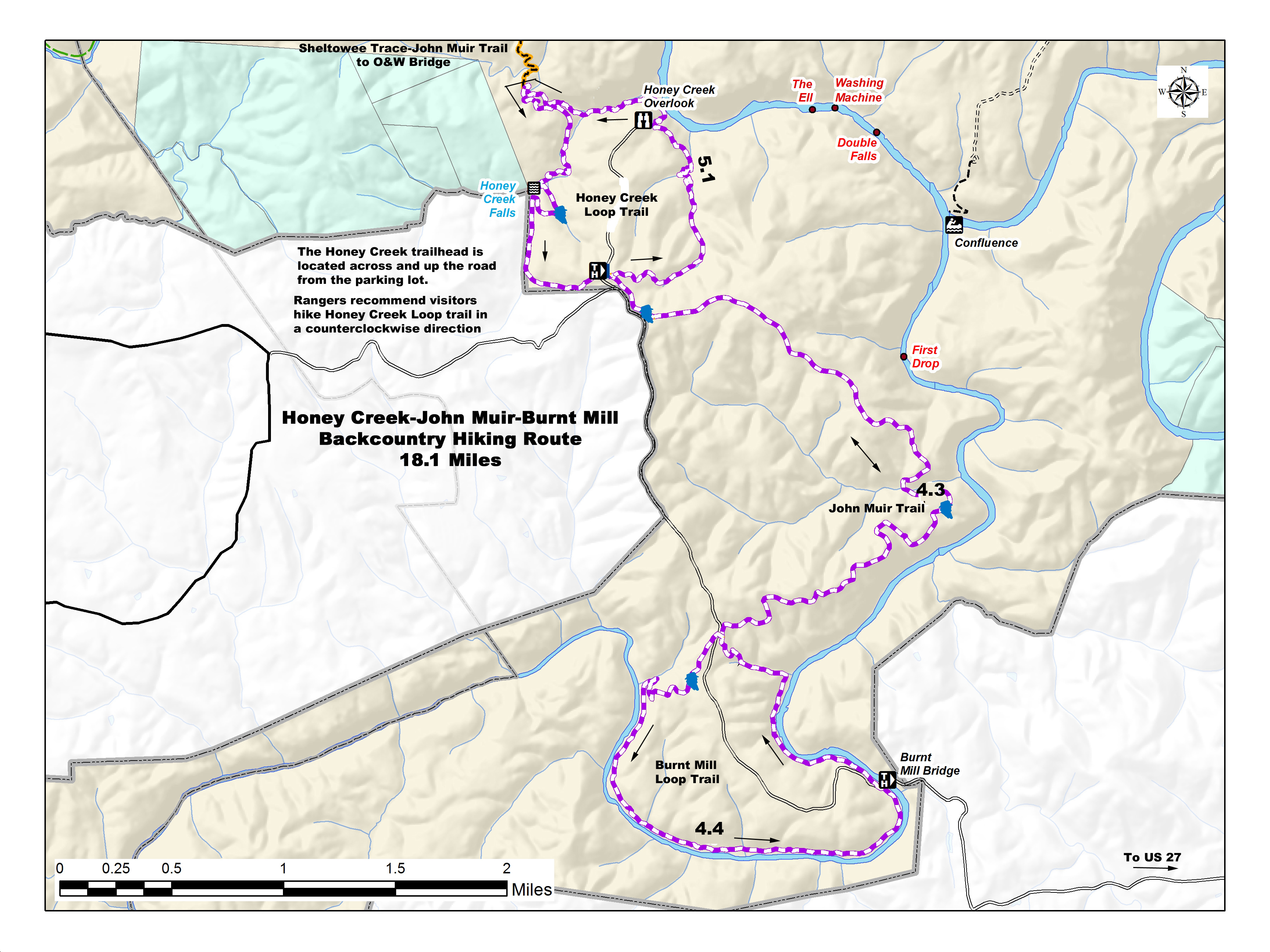
Honey Creek Loop
The Honey Creek Loop is the most challenging trail in Big South Fork. Along with the challenge come rewards for the hiker with the time and stamina to undertake the trip. The trail is 5.5 miles in length but requires extra time. Even experienced hikers should allow a minimum of 5 hours to complete this strenuous hike. Hazards include steep narrow trail sections, numerous creek crossings, slick boulders and confusing trail junctions. This hike is not recommended immediately following heavy rainfall or after severe freezing weather. The trailhead for Honey Creek is located In the southern portion of the park in Tennessee. It is a remote trailhead and is located about an hours drive south from Bandy Creek Visitor Center. It is off of the Mt. Helen Rd. to the west or Mountain View Rd. to the east.
Burnt Mill Loop
This easy 4.3 mile trail includes part of the John Muir Trail, which also connects it to the Honey Creek Trail. It follows the Clear Fork River for a portion of its length before climbing gradually to the ridges above the river. The views of the Clear Fork are well worth the minimal effort required to hike the trail. The trailhead is located in the southern part of the park in Tennessee off of the Mountain View Road.
Gentleman's Swimming Hole Trail
This moderate trail provides access to the traditional swimming hole on the Clear Fork River where the early English settlers of Rugby came to enjoy the cool waters of the river. The hiker has a choice of hiking 0.4 miles (one way) to the swimming hole and returning to the trailhead at Laurel Dale Cemetery or doing the complete 2.9 mile loop. Completing the loop takes you to the "Meeting of the Waters". This junction of the Clear Fork and White Oak Creek was the traditional "ladies bathing place." The trailhead for the Gentlemen's Swimming Hole is located at the Laurel Dale Cemetery in Historic Rugby. It is found in the south Tennessee portion of the park off of Hwy. 52.
East Side
Leatherwood Ford
Two large gaps in the bluffs and a low water ford in the river made Leatherwood Ford a natural crossing. Boardwalks provide a shady path along the river's edge. The area includes Angel Falls Rapid Trail (2 miles one way), Angel Falls Overlook Trail (2.8 miles one way), and the Grand Gap Loop Trail (6.8 miles loop), and O&W Trail (2.3 miles one way). Find the trailhead where Hwy. 297 crosses the Big South Fork River.
Leatherwood Loop and Sunset Overlook
Leatherwood Loop and Sunset Overlook begin at the East Rim Trailhead, which is on the right of the East Rim Road (off of Hwy. 297). The Sunset Overlook is an easy 1.3 mile (one way) trail. The hike out is not remarkable, but the view definitely is. The Sunset Overlook is not protected by railings or fencing of any kind. Use extreme caution, especially with children and pets. This Sunset Overlook hike can be done in an hour. Leatherwood Loop enters the woods on the same side of the road as the trailhead. The 3.3 mile Leatherwood Loop Trail features an overlook, and then descends to river level at Leatherwood Ford. To continue on the trail, take the steps beside the bridge and follow the guardrail to pick up the trail on the right.
East Rim Overlook
The East Rim overlook is an easy 300-foot walk on a paved walkway to the overlook. The trail is located at the end of East Rim Road, off of Hwy. 297.
Central Trails
Bandy Creek Loop Trail
A quiet stroll through the woods, this 1.3-mile loop trail may be started from the back of the Bandy Creek Visitor Center or across the parking lot at the far end of the pond.
Oscar Blevins Farm Loop
This easy trail leaves from Bandy Creek Trailhead and includes a wet weather water fall, rock shelters and the Oscar Blevins Farm. The trail is 3.6 miles long and takes most hikers 2-3 hours to complete. The trailhead is located 1/4 mile past the Bandy Creek Campground entrance on the left.
John Litton Farm Loop
The John Litton-General Slaven farm provides a glimpse of the subsistence lifestyle once so common in the Big South Fork. From the Bandy Creek trailhead, this 6.3-mile loop uses a 1.1-mile portion of the orange blazed Duncan Hollow Multi-Use Trail and then the Litton Farm Road. Hiking the loop counter-clockwise, turn left on each of these roads to return to the campground. If beginning the hike following Duncan Hollow Road first, watch for the sign that directs hikers to turn right on the Litton Farm Road at the TVA power line.
Other Central Trails to Note: View the PDF on top of this webpage to learn more about the West Entrance trails to Bandy Creek and Laurel Fork.
