|
You are viewing ARCHIVED content published online before January 20, 2025.
Please note that this content is NOT UPDATED, and links may not work. For current information,
visit https://www.nps.gov/aboutus/news/index.htm.
NPS
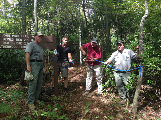
Contact: Wallace Linder, 423-569-9778 Contact: Matt Hudson, 423-346-6294 A new 2.3 mile section of the John Muir Trail in the Big South Fork National River and Recreation Area, from Devils Den to Honey Creek Loop, was completed this past National Public Lands Day, September 27, 2014. This new connection allows hikers to travel approximately 39 miles on the John Muir Trail from Pickett State Forest all the way to Honey Creek Loop trailhead. The new section of the John Muir Trail is also blazed as part of the Sheltowee Trace National Recreation Trail and the new section allows the extension of the Trace 14 miles deeper into the Big South Fork NRRA. Some of the costs related to the trail work were made possible by a donation to the Big South Fork NRRA from the Sheltowee Trace Association, a volunteer-based non-profit. "This new section of the John Muir Trail enables us to co-locate the Sheltowee Trace on some of the most beautiful, rugged terrain that showcases some of the best trail in the Big South Fork," said Steve Barbour, executive director of the Sheltowee Trace Association. "We see this addition as another step forward toward our goal of eventually connecting the Trace to the Cumberland Trail." The Sheltowee Trace is a 319 mile National Recreation Trail that was created in 1979 and now stretches from Honey Creek Loop in the Big South Fork NRRA to northern Rowan County, Kentucky. The trail is named after Daniel Boone, who was given the name Sheltowee (meaning "Big Turtle") by members of the Shawnee tribe. For information on hiking and other recreation opportunities in the Big South Fork National River and Recreation Area, please call (423) 286-7275. |
Last updated: April 14, 2015