NPS photo A Sacred Connection: Nature at Big Hole National Battlefield"Our traditional relationship with the earth was more than just reverence for the land. It was knowing that every living thing had been placed here by the Creator and that we were part of a sacred relationship…entrusted with the care and protection of our Mother Earth, we could not stand apart from our environment." – Elsie Maynard (Nez Perce) A Deep Connection to the LandFor the Nez Perce (nimí·pu·), the landscape of Big Hole and its natural resources—fish, elk, camas, lodgepole pine, grasses, water, minerals, and fertile soil—were integral to their way of life. These resources were not merely assets but part of a balanced and sacred relationship with the Creator and the earth. They shaped their culture, beliefs, and daily lives. The Role of Natural ResourcesWithout the abundant natural resources, the Nez Perce would not have traveled to Big Hole. Their traditional practices and sustenance were intertwined with the landscape, providing not only food and shelter but a profound spiritual connection to the area. Every plant, tree, animal, and stream held significance, woven into their customs and survival. Landscape and HistoryThe natural landscape of Big Hole also played a crucial role in the events of 1877. The familiarity that the Nez Perce had with the terrain provided them with a strategic understanding of their environment, influencing both their movements and their interactions during the battle. Preserving the BalanceToday, understanding the Nez Perce’s historical and cultural ties to these resources is essential to honoring and preserving the park. Big Hole National Battlefield’s commitment to protecting the landscape and its resources reflects the Nez Perce’s dedication to Mother Earth. By preserving these natural elements, we ensure that the story of Big Hole remains grounded in respect for the earth and the people who once called it home. 
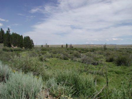
NPS photo Landscape and ClimateBig Hole National Battlefield spans elevations between 6,276 and 7,000 feet (1,913 to 2,134 meters), offering a varied terrain that is both beautiful and challenging. The climate, as recorded in Wisdom between 1971 and 2000, reflects the battlefield’s dry environment, with an average annual precipitation of just 12 inches (30 cm). Seasonal temperatures vary widely, with January highs and lows averaging 27°F and 1.5°F (-2.7°C and -16.9°C) and July reaching 77°F and 37°F(25°C and 2.7°C), respectively. Surrounding Land and Key FeaturesThe battlefield is surrounded by a mix of U.S. Forest Service lands and private ranches. The North Fork of the Big Hole River flows through the site, dividing its diverse terrain, while Battle Mountain stands to the northwest, and Ruby Bench extends along the southeastern edge. Together, these features form a landscape that is as complex as it is historic. Vegetation and HabitatsBig Hole National Battlefield supports a range of vegetation, from sagebrush uplands to riparian willow areas and coniferous forests. The battlefield’s five distinct habitat types reflect its ecological diversity:
Upper Columbia Basin Network Inventory & Monitoring ProgramBig Hole National Battlefield is part of the Upper Columbia Basin Network Inventory and Monitoring Program(UCBN I&M). This program brings scientists to the park to collect data and keep park managers informed about changes in the natural environment, helping them monitor species of concern. To explore more about the work of this network and to access species lists for plants, birds, and animals associated with Big Hole, please visit the UCBN I&M website through the National Park Service. |
Last updated: November 5, 2024
