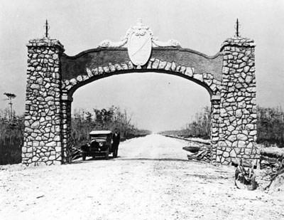
The Tamiami Trail, otherwise known as U.S. Highway Route 41, is a 284 mi (457 km) stretch of road connecting Tampa to Miami via Naples. Although many travelers choose to drive on interstate 75 to traverse Florida east and west, the historic Tamiami Trail, running parallel to the south, offers a thrilling, scenic drive through Big Cypress National Preserve and Everglades National Park.
In 1915, a representative from Fort Myers and a representative from Miami proposed the construction of this highway to connect these coastal cities to encourage tourism in South Florida. A representative of Tampa caught word of such project and decided to continue the road North combining both end destinations names into one: Tamiami. The counties that were included in the proposed route all agreed to pay and construct their own portion of the road, but in 1919 a few years after construction was well underway, Lee County ran out of money. Monroe county to the south excitedly stepped forward to build Lee’s portion in their own county altering the route only slightly.
Meanwhile in Southwest Florida, Barron Collier, an up-and-coming business tycoon had diversified his assets in various industries and millions of acres of wilderness, pledged to bankroll the completion of the Tamiami Trail in its original route. All Collier asked for in return, was that the State legislature designate the land surrounding this portion of the highway as a new county reflecting his name.
In April 1928, the Tamiami Trail was completed using the original route as Collier promised bypassing the piece completed by Monroe County left to be known as the south loop, or today, Loop Road. An estimated $7 million was spent on the entire construction and was viewed as an impressive engineering feat. As expected, the road brought many wealthy tourists to the area driving Elcars and Ford Model T’s and boosting the economy of South Florida. The Seminole and Miccosukee moved closer to the road to sell items to travelers. More people began settling in the area and increased logging and cattle grazing practices.
As the years went on after the Tamiami’s creation, the destruction to the ecosystem was quickly realized. The road acted as a dam to block the natural flow from Lake Okeechobee to Florida Bay and the Big Cypress Watershed flow into the Gulf of America. With such a large volume of water displaced, native flora and fauna found their natural habitats displaced and even removed entirely. To mitigate this loss, canals and culverts were added around the road in the 1990’s. Plans to build a bridge over the landscape and remove all the original road fill were proposed by The Florida Department of Transportation and Everglades National Park. Multiple of these projects have since been completed over the last 20 years raising the road and allowing water and wildlife to pass underneath. the final phase of this series was funded with intentions to have it completed by 2024. 
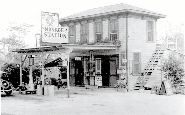
Soon after the Tamiami Trail was open, six service stations were constructed along the most remote stretch through Collier County. Fuel, food and other necessities were for sale to provide a welcome rest for road-weary travelers. The stations were situated 10 miles apart, and each was operated by a husband and wife. The husbands were designated by the Collier County Sheriff’s Office to patrol the five miles on either side of their station by motorcycle to assist travelers.
Monroe Station was one of the six service stations created and was located at the western intersection of Tamiami Trail and South Loop (Loop Road). The original husband that operated Monroe station died two months into duty due to a head on collision while patrolling on his motorcycle. These mounted Sheriffs were disbanded in 1934 though the buildings remained operational. Big Cypress National Preserve was established in 1974 and forced Monroe station to remove its gas tanks. Monroe station eventually went out of business a little over a decade later. |
Last updated: August 1, 2025
