Last updated: May 7, 2018
Article
Rocky Intertidal Monitoring in the San Francisco Bay Area

NPS / Jessica Weinberg McClosky

Why is the Rocky Intertidal Zone Important?
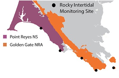
The rocky intertidal zone, or the band of rocky shore covered up by the highest of tides and exposed by the lowest of tides, is an extraordinarily diverse and productive ecosystem. More than 1,000 species of invertebrates and algae live in Central California’s rocky intertidal areas, and many more fish, birds and mammals rely on rocky intertidal species as a source of food. While rocky intertidal communities can withstand pounding surf and scorching sun, they are also highly sensitive to pollution, oil spills, invasive species and changing air and ocean temperatures. The National Park Service Inventory and Monitoring Program monitors rocky intertidal communities at five sites in Golden Gate National Recreation Area and Point Reyes National Seashore. Though rocky intertidal monitoring has taken place at some sites since 1989, adoption of a new monitoring protocol in 2006 developed for the Multi-Agency Rocky Intertidal Network (MARINe) has enabled direct comparison to more than 100 other MARINe network sites.
Why Do We Monitor Rocky Intertidal Communities?
- To detect population trends for select rocky intertidal organisms
- To detect trends at multiple scales—from site- and park-wide trends to regional patterns—by contributing this data to the larger MARINe monitoring network
- To better understand normal variations in rocky intertidal communities, and to identify abnormal changes such as overuse, disease spread or oil spill impacts
How Do We Use the Monitoring Data?
- To inform decisions about issues like coastal access, over-harvest, oil spill clean-up and endangered species (e.g. black abalone) recovery
- To study the effectiveness of California’s new Marine Protected Areas
- To assess and forecast the effects of climate change on rocky intertidal species

NPS / Jessica Weinberg McClosky
What Have We Learned?
Trends have been variable among the five sites monitored in Golden Gate and Point Reyes, each of which have their own distinct species assemblages. Monitoring has detected the clearest trends at the Alcatraz site, where rockweed and red algae have been steadily regaining lost ground in the aftermath of a 2007 oil spill.
For More Information
Point Reyes Marine Ecologist
Ben Becker
Golden Gate National Recreation Area Aquatic Ecologist
Darren Fong
Links
San Francisco Bay Area Inventory & Monitoring Network
Pacific Coast Science & Learning Center
Summary by Jessica Weinberg, July 2013.
Download PDF from the NPS Data Store
